Download
1 / 11
110 likes | 187 Views
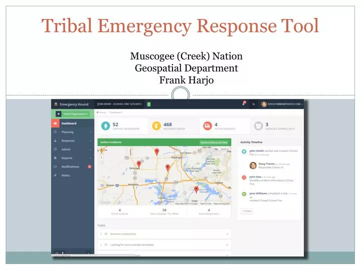
Tribal Emergency Response Tool. Muscogee (Creek) Nation Geospatial Department Frank Harjo. Muscogee (Creek) Nation. O kmulgee , OK located 30 miles south of Tulsa, OK Over 70,000 Tribal Citizens Tribal Jurisdiction covers 4,867 sq miles

E N D
Tribal Emergency Response Tool Muscogee (Creek) Nation Geospatial Department Frank Harjo
Muscogee (Creek) Nation • Okmulgee, OK located 30 miles south of Tulsa, OK • Over 70,000 Tribal Citizens • Tribal Jurisdiction covers 4,867 sq miles • Tribal Jurisdiction includes parts or all of 11 counties
Project Background • Grant Proposal • Collaboration with partner tribes • Citizen Potawatomi Nation • Kickapoo Tribe • Seminole Nation • Inter-Tribal Emergency Management Coalition • Address Tribal Emergency Response Information Exchange • 2013 Grant awarded to Muscogee (Creek) Nation to develop: • Tribal emergency management standards that address Incident Management and Resource management • Mobile application to allow updates in the field and synchronization capabilities • A geospatial data viewer to display partners’ emergency response info along with pertinent environmental data
Tribal EM Data Standards Incident Management: • The Tribal Incident Management data standard can be more comprehensive and capture incidents that tribes encounter on a regular basis (Wildfires, Tribal Government Campus, etc.) • Tribes can utilize the incident management system to manage incidents within the tribe • EM Personnel • Lighthorse • Risk Management • Communications • Facilities • Administration
Tribal EM Data Standards Resource Management: • The Tribal Resource Management data standard will address resources of the tribal government • Because tribes are unique and operate several aspects of tribal government, resources may vary from tribe to tribe. • Resources can range from critical facilities to personnel/teams • Being able to document and manage resources using data standards allows information to be streamlined • Streamline in the field…
Mobile Application– Incident Response • Log initial incident information • Identify potential environmental concerns in the surrounding area • Integration with web services • Organize Incident Command Team: • Credential validation • Check-in / check-out • Text (SMS) notifications • Onsite picture/video logging
Mobile Application – Post Incident Analysis • Review Incident Timeline • Generate various reports • Seamless mobile to Desktop transition
Technologies Desktop Mobile UI Tier jquery.js bootstrap.js knockout.js parsley.js appear.js smoothscroll.js slimscroll.js modernizer.js animate.js + • APIs • Capture • Geoloc • Storage • Notify Business Tier REST Web Services + Android-Specific Controllers iOS-Specific Controllers Synchronization for offline use Data Tier
Project Schedule – Key Dates • March - June 2014: 3 regional requirements gathering / design meetings held across OK • Spring 2014: Data Standard & Phase A (System Prototype) Development • Fall 2014: Phase B (Complete System without synchronization) Development • Spring 2015: Phase C (Complete System) • Summer 2015: Regional Training / Outreach Sessions