Download
1 / 55
630 likes | 926 Views
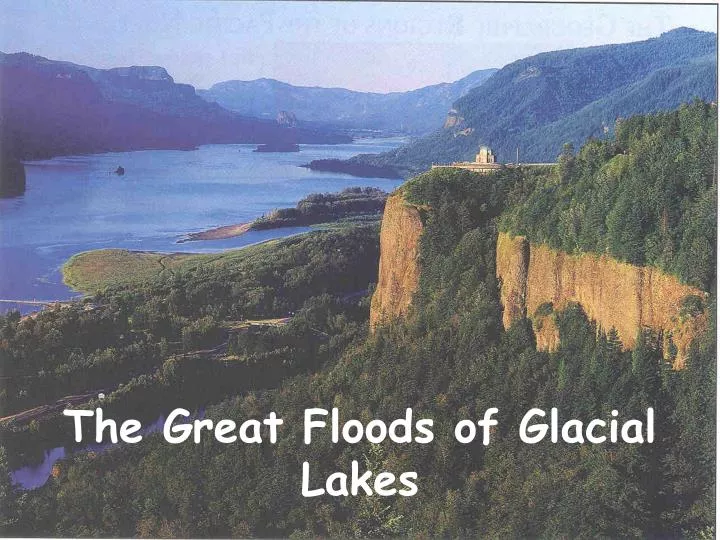
The Great Floods of Glacial Lakes. Colonnades of Columbia Plateau basalt. Rocks cascading into a lake left by a glacier in the Canadian Rockies. CORDILLERAN ICE SHEET - GLACIAL MISSOULA & COLUMBIA LAKES. Cordilleran Ice Sheet -- 4000 feet thick. End Moraine. Braided Stream. Steam Tunnel.

E N D
Rocks cascading into a lake left by a glacierin the Canadian Rockies
CORDILLERAN ICE SHEET - GLACIAL MISSOULA & COLUMBIA LAKES • Cordilleran Ice Sheet -- 4000 feet thick
End Moraine Braided Stream Steam Tunnel Ice Face What scientist think it would look like Retreating Glacier Ground Moraine Outwash Plain Pre-glacial Lake Drumlin
Large rocks (till) at the base of a glacier that have been plucked from the terrain as the ice moved over it.
The Cordilleran Ice Sheet south into northern Washington, Idaho, and Montana MISSOULA & COLUMBIA LAKES
Ice Age 15,000 and 12,800 y.a. • Near end of thePleistocene Epoch
CORDILLERAN ICE SHEET LOBES • Purcell Lobe blocked the Clark Fork River forming Lake Missoula Channeled Scabland • Okanogan Lobe blocked the Columbia River (at Grand Coulee Dam) forming Glacial Lake Columbia (Grand Coulee, Banks Lake, Steamboat Rock, Dry Falls, & Moses Coulee) • The Puget Lobe scoured the Puget Sound
PURCELL LOBE ICE DAM • Blocked Clark Fork River • (Idaho-Montana border)
Created Glacial Lake Missoula • Covering 7,800 square kilometers (western Montana) PURCELL LOBE
PURCELL LOBE ICE DAM Contained more water than Lakes Erie & Ontario combined • Held 2,000 square km. of water • Approximately 600 meters deep
1st Lake Missoula floated the Ice Dam • Ice dam, merely a small section of the lobe • three miles long • ten miles across • 2,000 feet tall PURCELL LOBE
1st Lake Missoula floated the Ice Dam • When the water behind the dam became deep enough • southern finger of the vast ice sheet • popped up like ice cubes in a glass of lemonade
2nd Burst through the Clark Fork Canyon • Ten times combined flow of all the rivers of the world PURCELL LOBE
THE FIRST FRONT OF THE FLOOD • Mass of water, debris, and ice 2,000 feet high • Raced toward the ocean at 65 miles per hour PURCELL LOBE
THE FIRST FRONT OF THE FLOOD • Inundating 16,000 sq. miles hundreds of feet deep • Quickly stripped 200 feet of soil • PURCELL LOBE
Such catastrophic floods etched coulees now known as the Channeled Scablandsin eastern Washington where water velocities were highest PURCELL LOBE
STOPPED AT WALLULA GAP Left scabs or erosion remnants of Basalt PURCELL LOBE
STOPPED AT WALLULA GAP • Several weeks 200 cubic miles of water per day to a gap that could discharge less than 40 cubic miles per day. • PURCELL LOBE
STOPPED AT WALLULA GAP • Water filled the Pasco basin, Yakima and Touchet Valleys forming temporary Lake Lewis • PURCELL LOBE
FINAL STAGES OF THE FLOOD The torrent widened and deepened the Columbia River Gorge, baring the majestic cliffs seen today PURCELL LOBE
Pushed back and reversed the flow of the Snake River all the way past Lewiston, Idaho. PURCELL LOBE
Temporary lakes formed in the Scablands and silt, sand, and gravel settled out of the water. PURCELL LOBE
Channeled Scablands • The very dark areas • = lakes and rivers
Missoula Floods Picked apart the bedrock, and carved an immense channel system into the land PURCELL LOBE
Where did all the loess, dirt, sand, gravel and silt end up? Some of the material were deposited in the Willamette Valley in Oregon
Flood Debris Iceberg deposit (glacial erratic) The flood ripped away huge boulders from the underlying lava rock and carried or floated them Photo compliments of the National Park Service
FINAL STAGES OF THE FLOOD Each time Lake Missoula emptied the Purcell lobe continued its southerly progression • Formed a new dam • Causing the lake to refill • Resulting in a new flood • Average of every 55 years or so for 2,000 years!
FINAL STAGES OF THE FLOOD • Piles of rocks left behind near Eugene were brought by icebergs broken off the original ice dam formed by the Purcell lobe of the Cordilleran Ice Sheet
Flood Debris Up to 40 times Many layers of glacial lake sediments are found situated on top of one another; each layer represents a separate filling of the lake
FINAL STAGES OF THE FLOOD • Not far from the present day site of Portland, the river makes two 90 degree turns. • Ice and debris formed a temporary dam causing the floodwaters to spill into the Willamette Valley as far south as present day Eugene
Looking at the evidence • Ancient shorelines on Mt. Jumbo • Missoula, MT
Ancient shorelines on Mt. JumboMissoula, MT • The highest known shorelines are found at an elevation of 4,200 feet.
Camas Prairie ripple marks 13-30 feet these ripple marks would dwarf any ordinary ripple mark
Lake Columbia -- • across Spokane • Cut deep canyons, or coulees in bedrock OKANOGAN LOBE
Coulee south of Coulee City. • Unlike the Grand Canyon, which was eroded by a river, the coulees of Washington were carved out by Ice Age floods. Okanogan Lobe
DRY FALLSby John Knapp http://www.bmi.net/knapp/whitman.html
Dry FallsEastern Washington Three & one-half miles wide, Dry Falls is five times the width of Niagara Falls Photo compliments of the National Park Service Okanogan Lobe
OKANOGAN LOBE • Soap Lake today is known as Dry Falls • Skeleton of one of the greatest waterfalls Okanogan Lobe
OKANOGAN LOBE Dry Falls is 3.5 miles wide with a drop of over 400 ft.
OKANOGAN LOBE Two Major North South Grand Coulees * Larger Upper Coulee -a river over an 800 ft. waterfall [4 miles Wide & 20 miles Long] * Lower Coulee is [7 m long and about 1 mile wide] Eroding power took pieces of Basalt rock causing the falls to retreat 20 miles and self-destruct (where Grand Coulee Dam is today) Okanogan Lobe
Okanogan Lobe • This is a view below and down the channel at • Palouse Falls. • Can you imagine the amount of water it took to carve out this canyon?