Download
1 / 50
500 likes | 584 Views
Fig. 6-CO, p. 138. Fig. 6-1, p. 140. Fig. 6-2, p. 141. Table 6-1, p. 141. Fig. 6-3, p. 142. Fig. 6-4, p. 142. Fig. 6-5, p. 143. Fig. 6-6, p. 143. Fig. 1, p. 144. Fig. 6-7, p. 145. Fig. 6-8, p. 146. Fig. 6-9, p. 146. Fig. 6-10, p. 147. Fig. 6-11, p. 147. Fig. 6-12, p. 147.

E N D
Lifting Along Weather Fronts Fig. 6-15d, p. 149
Convection and Clouds • A thermal starts the convection current rising as it reaches the LCL the cloud forms. • Convection continues and the cooler air (because of Condensation) flows outside the cloud and back down to the surface. • As clouds grow they cut off heating and convection. Without rising air, the cloud will begin to erode as droplets evaporate.
Convection and Clouds • As the cloud dissipates the heating renews and new thermals are produced which generate another cumulus cloud. • Cumulus come and go at the same spot. • However, if the air is hot and humid and the sky is full of cumulus clouds then, if there is no mixing of air, one thermal produces a cumulus cloud when RH is • 100% and rising air remains saturated...
Convection and Clouds • Let the lower region (A) of air below the LCL is conditionally unstable. Above the LCL (B) the air is absolutely stable and above that (C) there is a subsidence layer where the air is also absolutely stable. • Region A ELR = 7.5oC/km • Region B ELR = MALR = 6oC/km • Region C ELR = +6 oC/km
Convection and Clouds • If in Region B, the ELR becomes greater than the MALR, then the region becomes conditionally unstable and Cumulus Congestus clouds form. • If Regions A&B are both conditionally unstable, then Cumulonimbus form. • CN clouds are rarely in the stratosphere, they tend to spread out and form an anvil • at the top. At mid-lat, winds flatten the top.
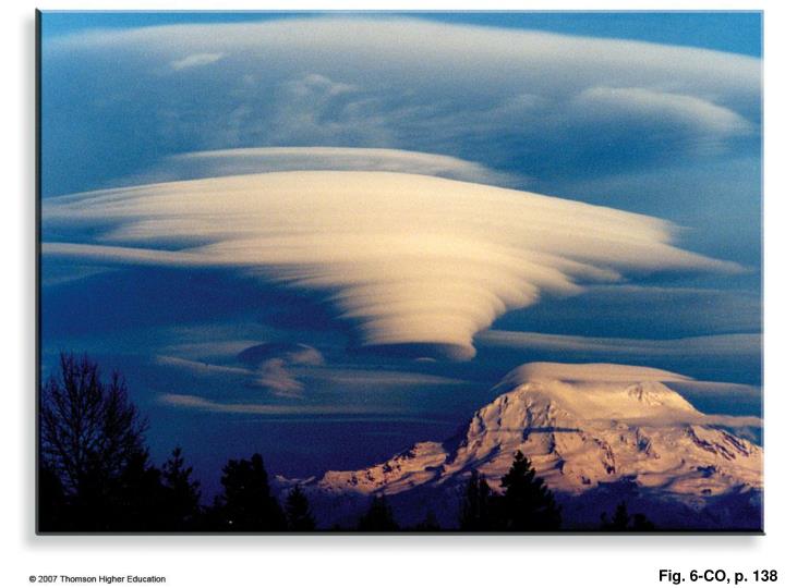
Mountain Wave Clouds • Some clouds form on the lee sides of mountains. • Stable air over a mountain may move in a wave shape. • Dry and near the top --> rotor clouds • Moist above top --> mountain wave clouds • Moist very high above the top ---> Lee wave clouds.
Changing Cloud Forms • With certain conditions • altostratus --> altocumulus • Conditions are: top of cloud -->cools • bottom of cloud -->warms • Similar effects for: stratocumulus and • cirrocumulus
Changing Cloud Forms • Uniform wind through cloud layer --> cloud streets. New cloud elements appear uniformly distributed. • When wind reaches a critical value --> billow clouds form.(Tops have wave shape form) • Altocumulus castellanus form when rising air causes conditionally unstable air above the cloud. The heat comes from condensation.
Mixing Moist Layers • Vertical mixing of moist stable air by the wind, causes the lower warm air to warm more and the top to cool, causing saturation and stratocumulus clouds to form. • If surface is very warm, thermals may move into the stable region and form congestus cumulus or cumulus clouds.