Download
1 / 31
310 likes | 511 Views
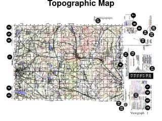
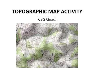
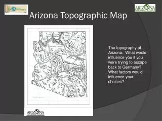
TOPOGRAPHIC MAP ACTIVITY. CBG Quad. 1. What is the name of this quadrangle?. Canonsburg Quadrangle. 2. What are the names of the eight adjacent quadrangles?. N: Oakdale NE: Pittsburgh E: Bridgeville SE: Hackett S: Washington East SW: Washington West W: Midway NW Clinton.

E N D
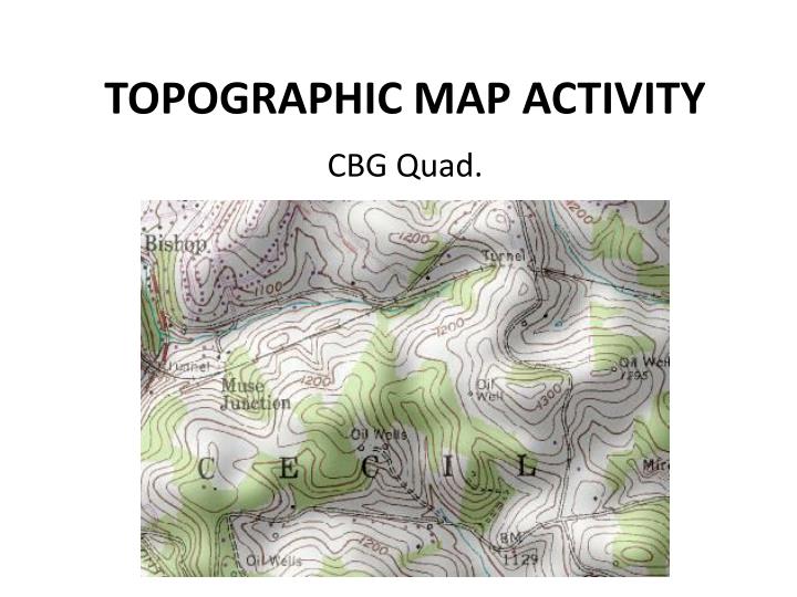
TOPOGRAPHIC MAP ACTIVITY CBG Quad.
1. What is the name of this quadrangle? • Canonsburg Quadrangle
2. What are the names of the eight adjacent quadrangles? • N: Oakdale • NE: Pittsburgh • E: Bridgeville • SE: Hackett • S: Washington East • SW: Washington West • W: Midway • NW Clinton
5. What is the ratio that represents the scale of this map? Explain what this ratio means. • 1 : 24,000 • For every 1 unit of measure you travel on the map, you would travel 24,000 of those same units on real land.
6. Draw the symbol(s) used for the following: school, church, cemeteries, US route, state route, and interstate route. 51
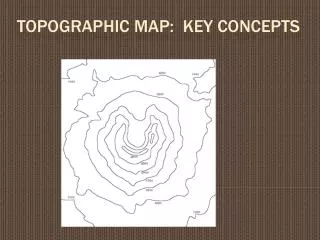
7. What do the brown lines on the map represent? • Contour lines = elevation
8. What do the following colors represent on a topographic map? • dark pink: borough, town, city • blue: water • black: human-made structures (buildings, houses, etc.)
9. What color is used to show revisions to the map? • Purple
10. What do the brown X’s on the map represent? • Benchmark = surveyed/measured elevation
11. Give the name for each place shaded in dark pink. • Canonsburg • Houston • McDonald • Strabane
12. Who mapped, edited, and published this map? • United States Geological Survey (USGS)
13. What latitude and longitude does this map cover? • 40⁰ 15’ 00” N to 40⁰ 22’ 30” N • 80⁰ 07’ 30” W to 80⁰ 15’ 00” W
14. What do the bold contour lines represent? • Index contours
15. Where is the highest point on the map and what is its elevation? • Northeast of Muse = 1380 ft • Latitude = 40⁰ 18’ 00” N • Longitude = 80⁰ 11’ 50” W
16. What creek runs through Canonsburg? • Chartiers Creek
17. What counties are represented on this map? • Washington & Allegheny
18. Name the major interstate that runs through this quadrangle. • I-79
19. What is the total number of schools found in McDonald, Houston, Canonsburg, and Strabane (those areas shaded dark pink). Don’t forget to include Canon McMillan High School? McDonald = 1 Houston = 1 Strabane = 1 Canonsburg = 8 + 1 (CMHS)
20. What is the total number of churches found in McDonald, Houston, Canonsburg, and Strabane (those areas shaded dark pink)? McDonald = 10 Houston = 2 Strabane = 1 Canonsburg = 23
21. What is the elevation of St. Patrick’s Cemetery (Canonsburg area)? • 1160 – 1240 ft
22. What is the elevation of Polish Cemetery (Canonsburg area)? • 1180 – 1220 ft
23. What is the elevation of Oak Spring Cemetery (Canonsburg area)? • 1040 – 1220 ft
24. What is the elevation of St. Michael’s Cemetery (Canonsburg area)? • 1160 – 1220 ft
25. What is the elevation of St. Mary’s Cemetery (Cecil area)? • 1000 – 1080 ft
26. What is the elevation of Hawthorne School in Canonsburg? • 1040 ft
27. What is the elevation of the school in Houston? • Between 960 – 980 ft
28. What is the elevation of the school in Midland? • 1020 ft
30. What is the elevation of the Cecil Jr. High School? • 1020 – 1040 ft