Download
1 / 22
291 likes | 806 Views
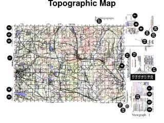
TOPOGRAPHIC MAP. DEFINITION. A topographic map is a type of map characterized by large-scale detail and quantitative representation of relief, usually using contour lines. Topographic Map Lines, Colors and Symbols. Features on a topographic map include:

E N D
DEFINITION A topographic map is a type of map characterized by large-scale detail and quantitative representation of relief, usually using contour lines
Topographic Map Lines, Colors and Symbols Features on a topographic map include: • Culture: roads, buildings, urban development, boundaries, railways, power transmission lines • Water: lakes, rivers, streams, swamps, rapids • Relief: mountains, valleys, slopes, depressions • Vegetation: wooded and cleared areas, vineyards and orchards • Toponymy: place names, water feature names, highway names
What's the difference between a topographic map and a regular map? Topographic maps allow you to see a three-dimensional landscape on a two-dimensional surface. These maps show the land's contours, elevations, mountains, valleys, bodies of water, vegetation and man made features such as roads or buildings .
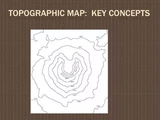
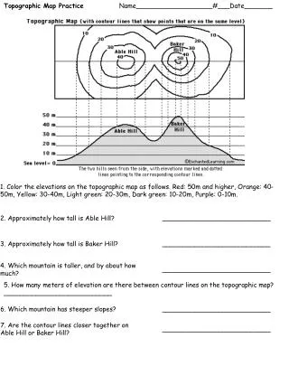
TopographicMapContourLines • Contour lines are lines drawn on a map connecting points of equal elevation. • They're useful because they illustrate the shape of the land surface • topographic maps show lines for certain elevations only. • These lines are evenly spaced apart. We call this spacing the contour interval.
TopographicMapContourLines • every fifth contour line is an index contour. Because it's impractical to mark the elevation of every contour line on the map, the index contour lines are the only ones labeled. The index contours are a darker or wider brown line in comparison to the regular contour lines.
TopographicMapContourLines • If the contours are close together, you're looking at a steep slope. If the contours have wide spaces in between -- or aren't there at all -- the terrain is relatively flat.
TopographicMapScale • Another thing you need to understand about a topographic map is scale. where one measurement on the map equals another larger amount in the real world. • The first number of the scale is always one the second number is the ground distance.
Hiking With a Topographic Map • Topographic maps are a valuable tool for hikers and campers. You can plan an entire trip with the help of a topographic map, and you'll greatly decrease your chances of any unpleasant surprises. Your map can tell you a lot -- details about an area's elevation, the best way to ascend a peak or how to orient yourself using landmarks. • Your map will also show you where to locate water as well as how to stay within the timberline in case you end up needing shelter. Don't forget to note the symbols on the map to ensure you're not hiking into any private property or dangerous areas such as mine shafts or caves.
A profile is appropriate when you are asked to construct a cross-section.
How do I construct a topographic profile? • To construct a topographic profile, you need to find a line on a map that is interesting. • Draw a line between the letters A A´ on the map.
How do I construct a topographic profile? • Take a piece of graph paper • Draw on it the two coordinate axes
How do I construct a topographic profile? • Fold the piece of paper on X axis. • Place the edge of the folded piece of paper along the line and mark the starting and ending points of the line that is the length of your profile line
How do I construct a topographic profile? • Start at one end and move along the edge of the paper, making a mark on the paper every time a contour line touches the edge of the paper. • Make sure you label each mark with the right elevation so that you can transfer that point to the correct elevation on your profile.
How do I construct a topographic profile? • Take note of the highest and lowest elevation on your map. • Label the y-axis (vertical lines) with elevations making sure that your scale goes from highest to lowest on your cross-section.
How do I construct a topographic profile? • we can transfer our elevations to the appropriate place on the plot. For example, the first elevation from left to right is 260 feet - on a vertical line, just above your tick mark for 260 feet, place a dot on the line that represents 260 feet.
How do I construct a topographic profile? • Finally, connect the dots with a smooth curve. .
How to calculate places on a map • Find the scale printed on the map. • The scale on the map shown is 1:50 000. Therefore, 1cm on the map = .5 km on the ground.
How to calculate places on a map • Using a ruler, measure the distance between two locations on the map and multiply that distance by the scale. • The distance is 4.82 cm. Multiply 4.82 cm by .5 km and you’ll get = 2.41 km.
How to calculate places on a map • calculate the difference of altitude between the two places on the map. • Make a triangule with the distance (base) and altitude • Calculate the diagonal which is the real distance between the two points of the map ----200 m----------------- 2,49 km ------------2,41Km--------------------