Download
1 / 4
40 likes | 307 Views
Landsat Program. The World’s Most Sophisticated Optical Observatories of the Earth. The World’s Model for International Collaboration in Earth Observation. Landsat 1 - 3 Multi-Spectral Scanner (MSS) 79 meter Return Beam Vidicon (RBV) 80/40 meter. Landsat International Cooperator Stations.

E N D
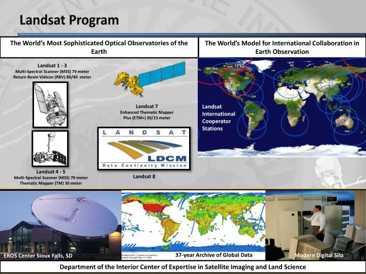
Landsat Program The World’s Most Sophisticated Optical Observatories of the Earth The World’s Model for International Collaboration in Earth Observation Landsat 1 - 3 Multi-Spectral Scanner (MSS) 79 meter Return Beam Vidicon (RBV) 80/40 meter Landsat International Cooperator Stations Landsat 7 Enhanced Thematic Mapper Plus (ETM+) 30/15 meter Landsat International Cooperator Stations Landsat 4 - 5 Multi-Spectral Scanner (MSS) 79 meter Thematic Mapper (TM) 30 meter Landsat 8 37-year Archive of Global Data Modern Digital Silo EROS Center Sioux Falls, SD Department of the Interior Center of Expertise in Satellite Imaging and Land Science
Landsat Web-Enabled Imagery Distribution Total Landsat Scenes Selected By Users Since October 1, 2008 • Over 2.4 million images available today • Seven fold increase in scientific and educational users • Data delivered to 180 countries • User shift to multi-year scenes at same location • Highly favorable user response • Exceeded 1 Million scenes selected on August 17, 2009 Daily Average = 3,125 scenes of web-enabled data selected 1M Scenes Selected Daily Average = 53 scenes for best year of sales (2001) Cumulative Scenes (Web-enabled) Cumulative Scenes (Sales) 2
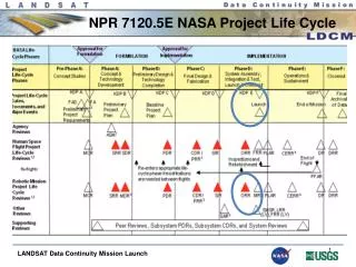
Beginning of a new era - Landsat Data Continuity Mission (LDCM) or Landsat 8 • Operational Land Imager (OLI) • 9 spectral bands (including new deep blue and cirrus bands) • 30m resolution for VIS/NIR/SWIR, 15m for PAN • 185km swath width • Collect 400 WRS-2 scenes/day; 265Mbps • Mission Characteristics • Orbit: Polar, 705km circular, sun-synchronous (WRS2), 98.2° inclined, mid-morning, 16-day repeat • Launch Date: Dec. 2012; Launch Vehicle: Atlas V • Mission Life: 5 Years (with consumables 10 years) • Mission Project Management: NASA/USGS DOI USGS developed Ground System • 4 design elements • Critical Design Review this week! • Thermal Infrared Sensor (TIRS) • TIRS in initial design at NASA; proposed in American Recovery and Investment Act of 2009 Approximately 100m resolution in 2 bands; 185km swath • Spacecraft • Observatory mass of 3085kg • Maximum power of 2130W • 3Tb Solid State Recorder • 384Mbps X-band downlink 3
Landsat 9 and Beyond • DOI/USGS has served as the Landsat data steward since program’s inception in 1966 • experienced several changes in program leadership, including two unsuccessful attempts to commercialize the satellites • DOI/USGS Joined NASA in 2000 as full partner in program management • Presidential Decision Directive NSTC-3 (5/94, revised 10/00) • NASA and DOI/USGS funded for Landsat 8 development; funding projected for USGS operations through 2017 • No agency yet has responsibility or funding for Landsat 9 or beyond • 8 Federal agencies recommend that DOI/USGS manage the Landsat program and NASA build and launch Landsat 9 and beyond (see A Plan for a U.S. National Land Imaging Program, National Science and Technology Council, 2007) • Definition of Landsat 9 needs to start in FY12 to support a launch in FY17 • DOI recognizes the need for a civil operational land remote sensing program and is starting to plan for Landsat 9 4