Download
1 / 30
300 likes | 388 Views
We Do Not See The Same Landscape Perspectives and Development of A Common Spatial Framework By Robert A. Washington-Allen Research and Development Staff Scientist DOE Oak Ridge National Laboratory Oak Ridge, TN 37831-6407.

E N D
We Do Not See The Same Landscape Perspectives and Development of A Common Spatial Framework By Robert A. Washington-Allen Research and Development Staff Scientist DOE Oak Ridge National Laboratory Oak Ridge, TN 37831-6407
A Spatial Framework is a mapped set of geographic regions that supports agency programs or studies McMahon et al. (2001) Environ. Manage. 28:293-316.
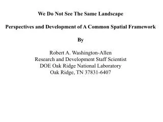
Landscape Composition and Configuration T1,T6 Shrubland Native Grassland T2 T4 Threshold T5 T3 T3 T4,T6 Threshold > 60 % Shrub Dense Shrubland Introduced Grasses T3,T5 T1: fire, T2: grazing, T3: heavy grazing, T4: cultural inputs, T5: drought, T6: wetter than average years sparse grass/ bare soil grass/bare soil dense grass/ bare soil denser grass/ bare soil shrub
Each region is relatively homogenous and distinct from adjoining regions. Distinctions are of two types: Specific characteristics of interest Broader categories of resource potential
Broader categories of resource potential • Quantitative vs Weight-of-Evidence (Qualitative) Methods • Visual Pattern Recognition vs Data-Driven Perspectives
Bailey (1995, 1996) delineated 52 ecoregions at the finest province level, increased from 30 in his original Bailey (1983) version. Other, different ecoregions, based on other criteria and for other purposes, have been specified by Holdridge (1947), Walter and Box, Thornwaite, Koppen and many others. Because the delineation is based on subjective criteria, there are as many sets of ecoregions as there are experts.
US EPA : Omernick's 1987 aquatic ecoregions were based on perceived patterns of a combination of causal and integrative factors, including land use, land surface form, potential natural vegetation, and soils. Although delineated for national-level studies of water resources, Omernick's 76 national ecoregions have been borrowed for many other kinds of ecological studies as well.
The National Resources Conservation Service (NRCS) has developed a version of ecoregions called Major Land Resource Areas (MLRAs). MLRAs are much finer than most of the other types of ecoregions; for example, there are 78 MLRAs in the 13 southeastern states. MLRA boundaries are drawn with regard to edaphic and physiographic relationships, but are still subjective.
Clustering is data-driven and empirical. This objectivity means that one obtains the same result every time, given the same data and a request for the same number of clusters. This is in contrast to regions drawn by expert opinion.
U.S. Forest Service Southern Global Change Program National map clustered on elevation, edaphic, and climate variables into 3000 ecoregions using similarity colors.
Towards a Common Spatial Framework • Regions are areas within which abiotic and biotic capacities and potentials are similar. • Foster an ecological understanding of a landscape’s terrestrial and aquatic resources. • Provide the basis for interagency coordination and collaboration in the design and implementation of ecosystem research, assessment, and management. • Fully integrated Peer-reviewed (participating agencies) National Map developed with common objectives.