Download
1 / 43
430 likes | 439 Views
Economic Storm Protection Value of Coastal Dunes An Isle of Palms, South Carolina Case Study. By: Alex Braud Master of Environmental Studies & Public Administration Thesis Advisor: Dr. Norm Levine. Ecosystem Service Valuation Studies.

E N D
Economic Storm Protection Value of Coastal DunesAn Isle of Palms, South Carolina Case Study By: Alex Braud Master of Environmental Studies & Public Administration Thesis Advisor: Dr. Norm Levine
Ecosystem Service Valuation Studies “Without coral reefs, annual flood damages from storms could double globally” “As communities rebuild after hurricanes, study shows wetlands can significantly reduce property damage”
Ecosystem Service Valuation Studies Ecosystem Services Water Quality Aesthetics Recreation • Purpose • Enables Informed Decision Making • Non-Market Values • Benefit-Cost Analysis (Local & Federal Funding) Storm Protection Habitat
Dunes Travelersdigest.com AP Photo/Wayne Parry Jekyllisland.com
Historically Neglected Dunes Undervalued & Under-Appreciated In Society
Borough of Harvey Cedars v. Karan – March 2012 The Claim: "The formerly spectacular ocean view from the Karans' house is now partially blocked by the 22-foot high dune, which occupies one-third of their land." The Ruling: Harvey Cedars was ordered to pay $375,000 for taking away the Karans' view. www.beneescola.com Robert Ward/App.com Staff Photographer
Superstorm Sandy – October 2012 Robert Simmon and NASA and NOAA GOES Project Science Team Consumerreports.org
Long Beach Island, New Jersey Ship bottom Harvey cedars 46% Homes Damaged $69 Million • 6.2% Homes Damaged • $11 Million Dunes No Dunes Ediblejersey.ediblecommunities.com
Investment in Dune Construction Federal Government Spending Towards Dune Construction Increased Costly – averages $1 million to $10 million/mile How can a community justify the costs? What is my return on investment?
PROBLEM What Is The Value of Storm Protection That Dunes Provide? How Do We Estimate This Value?
How do we estimate ecosystem services? • Example Methods: • Willingness to Pay • Travel Cost Method • Replacement Cost Method • Hedonic Pricing • Damages Avoided Storm Protection-Expected Damages • Expected Damages = Risk • Risk = Hazard x Exposure x Vulnerability • Hazard • With/Without Scenario • Flood Hazard Model • Vulnerability/Exposure • If nothing is behind dune - the storm protection value is nonexistent • Depth-Damage Curve UN-Spider
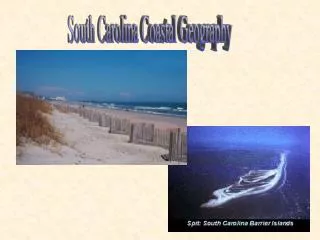
Isle of Palms • Selection Process: • Local • Available Data • Variability in Dunes/Development • Relatively Flat Beach • Dune Toe around 6 Feet NAVD88 • Dune Crests range 12 – 15 Feet NAVD88 • Dune Fields range 50 – 250 Feet Wide C21charlestonrealestate.com Palmscharleston.com
Category 4 • 120 mph maximum winds • 11 – 12 Feet NAVD88 Storm Surge • 200 Structures Destroyed • Older homes built at ground level unreinforced cinder blocks • Buildings elevated on pilings fared better • Lower primary dune ridge • Litchfield Beach had 20 ft dunes and experienced significantly less damage Hurricane HugoSeptember 1989 Katuna (1991)
Flood Hazard Model • FEMA – Flood Insurance Study National Academies of Science (2009)
Charleston County Flood Insurance Study (2016) • Preliminary Status • Need to Re-Create Analysis National Academies of Science (2009)
FEMA Erosion vs. 2016 FIS Model Validation
Scenarios FEMA (2018)
540-Rule – Erosion Treatment FEMA (2018)
Depth Damage Function Tate, Munoz, Suchan (2015)
Value of the Dune? $4,254,264.50
Small Difference Between Scenarios • Wave Height relational to stillwater depth • If difference in depth is minimal, minimal differences in wave height
540-Rule Skepticism • The origin of the FEMA 540-Rule came from studies by Hallermeier and Rhodes (1986) and by Dewberry & Davis, LLC (1989) • The 540-Rule has not been validated (National Research Council, 2009) • Erosional effects from the 100-year storm could be studied to apply more appropriate erosional profiles along Isle of Palms
True Vulnerability? FIRST FLOOR ELEVATION
Over 2000!
Buildings First Floor Elevation (NAVD88)
Buildings First Floor Elevation Above Ground Elevation
1,963 out of 3,499 Buildings (56%) How to Estimate Remaining 1,536 Buildings?
Geographically-Weighted Regression Analysis Predict Missing First Floor Elevations
Buildings First Floor Elevation
Value of the Dune? $4,254,264.50 If Ground Elevations were used instead of First Floor Elevations $14,919.12 With First Floor Elevations
Lower SWEL *1% SWEL in 1991 was 12.0 feet NGVD29 (11.0 feet NAVD88) plus 2.6 feet for Wave Setup (Wave Setup Included in 2016 SWEL) *Isle of Palms Transects were analyzed Post-Hugo
Buildings on Isle of Palms built High Effective 100-Year SWEL Preliminary 100-Year SWEL FEMA (2017)
Buildings First Floor Elevation Above FEMA Erosion Scenario