Download
1 / 10
130 likes | 341 Views
Mau Forest O verview. What is the Mau forest?. Largest remaining block of montane forest in Eastern Africa—an area > 400,000 ha. 21 Forests, 1 of which (Maasai Mau) is managed by local government (Narok County Council)

E N D
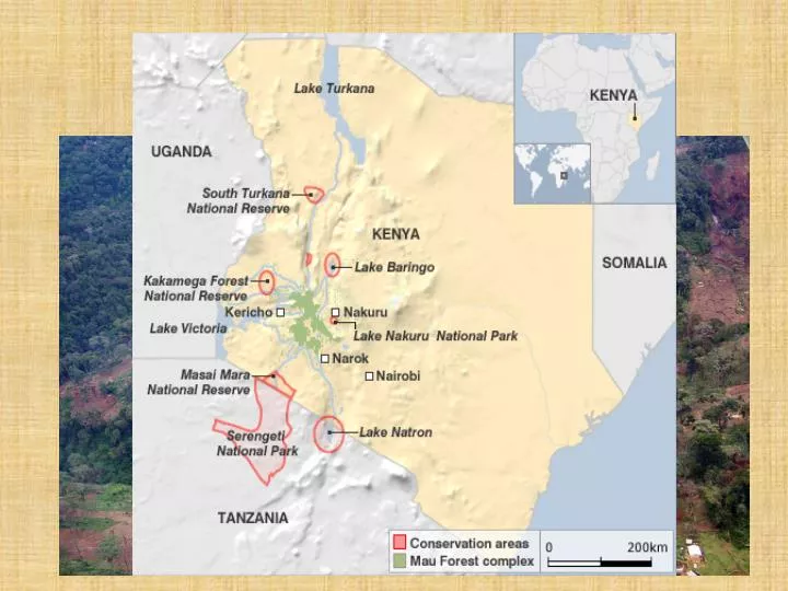
What is the Mau forest? • Largest remaining block of montane forest in Eastern Africa—an area > 400,000 ha. • 21 Forests, 1 of which (Maasai Mau) is managed by local government (Narok County Council) • One of 5 ‘water towers’ of Kenya; covers upper catchments of the Nzoia, Yala, Nyando, Sondu, Mara and Ewaso Ng’iro riversE. Africa lakes and wetlands; i.e., Victoria, Baringo, Natron, Turkana, Nakuru and Naivasha
Importance of the Mau • The Mau complex nourishes Kenya’s two largest foreign exchange earners—tea and tourism—in addition to many smallholder livelihoods (cattle, crops, forest products) • A significant portion of Kenya’s—as well as Tanzania’s—key wildlife populations depend on the Mau complex for water
Biodiversity values • Contribution to priority wildlife conservation areas • Freshwater biodiversity • Indigenous forest • Important Bird Areas (#5) • Farms & agrobiodiversity
LTPR dynamics • Reserve forests (government owned) • Maasai group ranches increasingly fragmented • Ogiekterritory • Titled land • Legitimate • Non-legitimate • ??? • Refugee camps
LTPR dynamics Indigenous people
Direct conflict drivers • Excisions • Removals • Unsustainable and inequitable forest management
Underlying dynamics: demand for land and water • Population pressure and immigration • Uncontrolled water use
Underlying dynamics: power struggles and patronage • Corruption and ethnically-manipulated land concessions combined with drought led to violence and population displacement • Lack of opportunity for youth • Proliferation of management units, no coherence; struggling over jurisdiction and benefit • Marginalization and “developmental distance”
PROMARA interventions • Community center • Information and legal advice on land rights targeted at vulnerable populations • Alternatives to land alienation and evictions • Integrated governance and co-management of natural resources providing livelihood and ecosystem service benefits