Download
1 / 1
10 likes | 103 Views
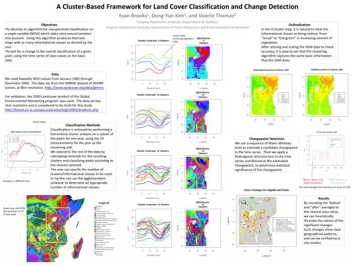
Objectives To develop an algorithm for unsupervised classification on a single variable (NDVI) which takes intra-annual variation into account. Using this algorithm produces thematic maps with as many informational classes as desired by the user.

E N D
Objectives • To develop an algorithm for unsupervised classification on a single variable (NDVI) which takes intra-annual variation into account. Using this algorithm produces thematic maps with as many informational classes as desired by the user. • To test for a change in the overall classification of a given pixel, using the time series of class values as the basic data. Ordinalization In the 4 Cluster map, it is natural to treat the informational classes as being ordinal, from “Scrub” to “Evergreen” in increasing amount of vegetation. After resizing and scaling the GEM data to check accuracy, it is easy to see that the clustering algorithm captures the same basic information that the GEM does. Classes have increasing vegetation order Data We used biweekly NDVI values from January 1982 through December 2006. The data are from the GIMMS dataset of AVHRR scenes, at 8km resolution. http://www.landcover.org/data/gimms For validation, the 2000 Landcover product of the Global Environmental Monitoring program was used. The data set has 1km resolution and is considered to be truth for this study. http://bioval.jrc.ec.europa.eu/products/glc2000/products.php A Cluster-Based Framework for Land Cover Classification and Change Detection Similar pixels Classification Methods Classification is achieved by performing a hierarchical cluster analysis on a subset of the pixels for one year, using the 24 measurements for the year as the clustering unit. We extend to the rest of the data by calculating centroids for the resulting clusters and classifying pixels according to the nearest centroid. The user can specify the number of clusters/informational classes to be used, or he/she can use the agglomeration schedule to determine an appropriate number of informational classes. Changepoint Detection We use a sequence of Mann-Whitney tests to estimate a candidate changepoint in the time series. Then we apply a Kolmogorov-Smirinov test to the time series, partitioned at the estimated changepoint, to determine statistical significance of the changepoint. Evan Brooks1, Dong-Yun Kim1, and Valerie Thomas2 1Virginia Polytechnic Institute, Department of Statistics 2Virginia Polytechnic Institute, Department of Forest Resources and Environmental Conservation “Before” Mean: 2.64 (lightly deciduous) “After” Mean: 2.09 (mostly grass) Belongs in a different class This pixel changed from Deciduous to Grass in 1996 Legend Results By rounding the “before” and “after” averages to the nearest class value, we can heuristically illustrate the nature of the significant changes. Such changes show clear geographical patterns, and can be verified by in situ studies. Study Area, with GEM data (compare to 19 Cluster map)


![A [simple] land cover change intercomparison](https://cdn2.slideserve.com/3941152/a-simple-land-cover-change-intercomparison-dt.jpg)