Download
1 / 18
180 likes | 268 Views
Advancing an Information Model for Environmental Observations. Jeffery S. Horsburgh Anthony Aufdenkampe, Richard P. Hooper, Kerstin Lehnert, Kim Schreuders, David G. Tarboton. CUAHSI HIS Sharing hydrologic data. Support EAR 0622374. request. return. return. request. NAWQA. return.

E N D
Advancing an Information Model for Environmental Observations Jeffery S. Horsburgh Anthony Aufdenkampe, Richard P. Hooper, Kerstin Lehnert, Kim Schreuders, David G. Tarboton CUAHSI HIS Sharing hydrologic data Support EAR 0622374
request return return request NAWQA return request request return NAM-12 return request request return NWIS request return return request return request The Original ProblemCombining Similar Data from Disparate Sources NARR Slide from Michael Piasecki
CUAHSI Hydrologic Information SystemA Services Oriented Architecture for Sharing Hydrologic Observations Slide from Steven Brown
Point Observations-Network Information Model Data Source USGS NWIS NWIS Sites Network Sites San Marcos River at Luling, TX Variables Discharge Observation 18,700 cfs, 3 July 2002 {Value, Time, Qualifier} • A data source operates an observation network • A network is a set of observation sites • A site is a point location where one or more variables are measured • A variable is a property describing the flow or quality of water • A value is an observation of a variable at a particular time • A qualifier is a symbol that provides additional information about the value
Data Values – Indexed by “What-Where-When” Time, T t “When” A data value vi (s,t) “Where” s Space, S Vi “What” Variables, V
Data Series – Time Series of Data Values Time End Date Time, t2 There are n measurements of Variable Vi at Site Sj from time t1 to time t2 Count, n Begin Date Time, t1 Site, Sj Space Variable, Vi Variables
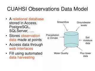
Observations Data Model (ODM) Streamflow Groundwater levels Precipitation & Climate Soil moisture data Flux tower data Water Quality • A relational database at the single observation level • Metadata for unambiguous interpretation • Traceable heritage from raw measurements to usable information • Promote syntactic and semantic consistency Horsburgh, J. S., D. G. Tarboton, D. R. Maidment, and I. Zaslavsky (2008), A relational model for environmental and water resources data, Water Resources Research, 44, W05406, doi:10.1029/2007WR006392.
Set of query functions ReturnsdatainWaterML WaterML and WaterOneFlow WaterML is an XML language for communicating water data WaterOneFlow is a set of web services based on WaterML
Metadata Catalog Database HydroCataloghttp://hiscentral.cuahsi.org • Service registry • Metadata harvester • Catalog database • Semantic tagging application • Data discovery services Hydrologic Concept Ontology Data Discovery Web Services
HydroDesktop – Data Access and Analysis Thematic keyword search Integration from multiple sources Search on space and time domain
A Common Information Model Has Enabled • A greater degree of semantic and syntactic homogeneity across data sources • Ability to catalog and provide semantically enabled search services across multiple disparate data sources • Evolution toward community standards for sharing hydrologic data
Limitations • Works great for a limited class of hydrologic observations (e.g., point time series), BUT… • Does not adequately support some types of ex situ observations • Does not adequately support observations on geometries other than points • Does not adequately describe the “feature of interest” or the “sampled feature” or “Site Type” • Does not provide adequate ability to record provenance and annotate observations • …
Critical Zone Research Stream chemistry Precipitation Soil chemistry Streamflow Soil moisture Groundwater chemistry Groundwater levels Solid earth chemistry http://criticalzone.org/Research.html Both in situ and ex situ data are critical for analysis of the critical zone.
Coupled Human/Natural Systems Snow depth, distribution, density Precipitation Diversions, human water management Reservoir inflows, storage, releases Irrigation, Evapotranspiration Streamflow quantity, quality Groundwater withdrawal, recharge, quality Data representing multiple hydrologic features with complex geometries.
A More Flexible Information Model for Observations • A number of important advancements have emerged • Information Model • Open Geospatial Consortium Observations & Measurements • Service Interfaces • Open Geospatial Consortium Standards – particularly Sensor Observation Services (SOS) • Semantics and Integration • Scientific Observations Network (SONet) • Data Storage Model • Microsoft Research and SDSC Environmental Data Model (EDM)
International Standardization of WaterML http://external.opengis.org/twiki_public/bin/view/HydrologyDWG/WebHome Hydrology Domain Working Group - working on WaterML 2.0 - organizing Interoperability Experiments focused on different sub-domains of water - towards an agreed upon feature model, observation model, semantics and service stack Iterative Development Timeline WaterML 2 SWG (Mar 2011) Groundwater IE • GSC+USGS • Dec 09 – Dec 10 Surface Water IE • CSIRO+many • Jun 10 – Sep 11 Forecasting IE • NWS+Deltares? • Sep 11 – Sep 12? Water Quality IE Water Use IE June’11 Slide from IlyaZaslavsky
ODM 2.0 • Approach: a core observational data model with flexible extensions • Samples extension – better handle storage of sample information and observations derived from ex situ analyses • Field sensor extension – better handle storage of sensor deployment information and in situ observations • Provenance and annotation – capturing more of the context of observations • A more robust “feature model” to better describe the geographic context of observations • Enhanced semantics • Harmonization with WaterML
Thank you! CUAHSI HIS Sharing hydrologic data Support EAR 0622374