Download
1 / 15
150 likes | 227 Views
Wind Channeling in the St. Lawrence River Valley: Synoptic Patterns, Local Conditions, and Operational Forecasts The Eleventh Northeast Regional Operational Workshop 4-5 November 2009 Albany, New York Alissa Razy, Eyad Atallah, John Gyakum Department of Atmospheric & Oceanic Sciences

E N D
Wind Channeling in the St. Lawrence River Valley: Synoptic Patterns, Local Conditions, and Operational Forecasts The Eleventh Northeast Regional Operational Workshop 4-5 November 2009 Albany, New York Alissa Razy, Eyad Atallah, John Gyakum Department of Atmospheric & Oceanic Sciences McGill University
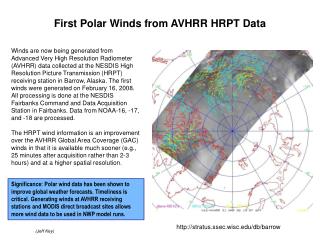
Data • hourly surface data (winds) recorded at YUL • North American Regional Reanalysis (NARR) dataset • developed by the National Centers for Environmental Prediction (NCEP) • 32 km horizontal resolution • 45 vertical layers • analyses performed every 3 hours
Observed Wind & Geostrophic Wind
{ Pairing a { Pairing b
Pairing a (northeasterly surface winds) n = 210 Pairing bspeed - Pairing aspeed = 5.3 knots Pairing b (southeasterly surface winds) n = 207
Difference Fields: Pairing b (SE) - Pairing a (NE) MSLP (contours) & 1000-500mb thickness (shading)
Pairing a: NE sfc winds (red) & Pairing b: SE sfc winds (blue) stability = ϴ925 – ϴ1000 Pairing bstab - Pairing astab = -2.6 K
{ Pairing d { Pairing c
Pairing c (northeasterly surface winds) n = 52 Pairing d (southeasterly surface winds) n = 192
Difference Fields: Pairing d (SE) - Pairing c (NE) MSLP (contours) & 1000-500mb thickness (shading)
Pairing c: NE sfc winds (red) & Pairing d: SE sfc winds (blue) stability = ϴ925 – ϴ1000 Pairing dstab - Pairing cstab = -2.5 K
Summary south-southeasterly to south-southwesterly geostrophic winds • northeasterly surface winds • low/high couplet • weaker gradients • weaker upper-level pattern • stronger stability • warm air advection • southeasterly surface winds • low/high couplet • tighter gradients • more saturated • stronger upper-level pattern • larger amplitudes • smaller wavelengths • lower stability • less suppressed mixing