Download
1 / 25
250 likes | 359 Views
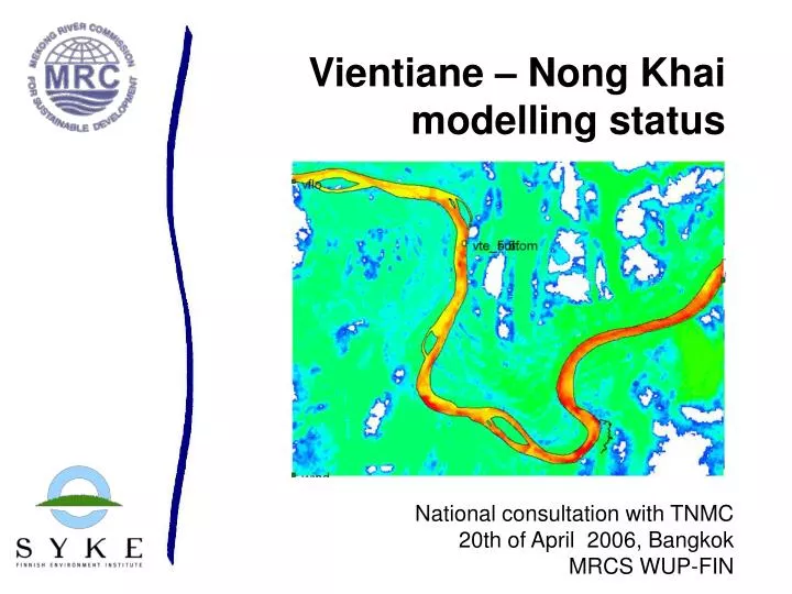
Vientiane – Nong Khai modelling status. National consultation with TNMC 20th of April 2006, Bangkok MRCS WUP-FIN. Bank erosion model in Vientiane- Nong Khai. magnitude of change motivation: causes analysis, support in protection measures, transboundary impact assessment

E N D
Vientiane – Nong Khai modelling status National consultation with TNMC 20th of April 2006, Bangkok MRCS WUP-FIN
Bank erosion model in Vientiane- Nong Khai • magnitude of change • motivation: causes analysis, support in protection measures, transboundary impact assessment • model developments, data collection (Lao-Thai cooperation)
Outline • Data status • Study area • WL • Field work • Aerial photos and satellite images • Modelling status • Model framework • Calibration • Outcome
Measured WL • 3 stations by JICA (01/2002- ) • Vientiane port • Nong Khai
Field data: Vientiane – Nong Khai section of Mekong River • ADCP flow and TSS flux, morphometry; Laos- Thai cooperation team, May 2005- May 2006 • Additional grant from Finland (Matti PhD) • CREST Yamanashi programme on Mekong morphometry, 2005-2006 • Iwona Conlan PhD
Field team • Lao PDR: Prasit Dimnivong Phoumyenh Khounthikoumanne Keomany Luanglith • Thailand: Sukkhawit Buaphuan Kiattiyot Yotteentian Sangwian Angkhuan • WUP-FIN: Matti Kummu Jorma Koponen Juha Sarkkula
TSS measurements • 9 point samples for each cross-section • 6 times / year • To correlate the backscatter of the ADCP measurements
Historical bank erosion analysis • Based on aerial photos and satellite images + GPS survey • Aerial photos • 1960s • 1990s • Satellite images • SPOT5 image from 2004
Modelling status • Data status • Study area • WL • Field work • Aerial photos and satellite images • Modelling status • Model framework • Calibration • Outcome
Boundary conditions Boundary at CS1: Discharge generated from water levels Boundary at CS4: Rating curve based on the ADCP measurements
Model results: velocity fields Surface: Bottom:
Vientiane application • Done: • Improved topography • Addition of measured water levels for calibration and validation • Solution of boundary instability • First results of the model calibration (on-going task) • Remains to be done: • Hydrodynamic calibration and validation • Calculation of sediment and comparison with the measured values • Cross section graphics correction
Outcome of the modelling work • Potential bank erosion rates due to the sediment transportation and flow • Impact of the changes in flow regime and/or sediment concentration from upstream • Local impacts ( built structures, bank protection, etc) on flow speeds, erosion, and sediment concentrations • Increase the understanding of the sediment dynamics in Mekong • Increase the understanding of the historical bank erosion • Recommendations • Understanding better the causes of bank erosion