Download
1 / 1
10 likes | 94 Views
J.C. Green, D. N. Baker, H. W. Kroehl, E. A. Kihn, J.B. Blake, J.F. Fennell, G.D. Reeves, R.H.W. Friedel, S.F. Fung, R.E. McGuire, G.M. Mason, S.G. Kanekal, E.J . Rigler, S.R. Elkington, and R.S. Weigel. Vision for a Virtual Radiation Belt Observatory (ViRBO).

E N D
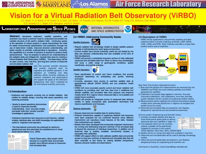
J.C. Green, D. N. Baker, H. W. Kroehl, E. A. Kihn, J.B. Blake, J.F. Fennell, G.D. Reeves, R.H.W. Friedel, S.F. Fung, R.E. McGuire, G.M. Mason, S.G. Kanekal, E.J . Rigler, S.R. Elkington, and R.S. Weigel Vision for a Virtual Radiation Belt Observatory (ViRBO) Abstract: Aerospace engineers, satellite operators, and scientists now share a common need to understand and predict the variable structure of the earth’s radiation belts. Continuing upsets to the operation of critical systems in space demonstrate the need for better environmental specifications and predictions through the use of data-driven models, improved physical understanding, and better transfer of scientific understanding to operations. Currently, the capabilities of a number of partners is required to achieve these advancements. Thus we propose to advance our understanding of the radiation belts and mitigate the hazards they pose by creating a Virtual Radiation Belt Observatory (ViRBO). The observatory will be an open access, near real-time, and long-term archive of observed and simulated radiation belt c • 2.0 ViRBO: Addressing Community Needs • Satellite Engineers: • Require radiation belt climatology models to design satellite systems capable of withstanding the harsh space environment. • Current models have proved extremely useful but are limited by the data and physical understanding that was available at the time of their development. • ViRBO will provide a centralized long-term archive of inter-calibrated measured and simulated data from which to derive new climatologies that cover a wider range of geomagnetic conditions, spatial coordinates, and particle energies. • Satellite Operators: • Need specification of current and future conditions that provide situational awareness for anticipating and quickly resolving anomalies. • Currently, operators have access to real-time satellite data at geostationary altitude (NOAA GOES) and one predictive model (REFM). • ViRBO will more accurately specify current and future radiation belt conditions by providing near real time data from 2 additional low altitude satellites and simulated data from physical and empirical models which fill in regions where measured data is not available and predict future conditions. • ViRBO will provide an integrated source of measured data allowing models to easily incorporate data assimilation techniques that improve specification and forecasts. • Science Community: • Require observed and modeled data for testing theory. • Physical mechanisms capable of explaining radiation belt dynamics have been proposed but not confirmed because many different mechanisms can reproduce broad features of the belts. Detailed inter-comparisons are needed. • Models have been developed that incorporate proposed mechanisms but running and distributing long-term archives of the simulated data is beyond the resources of individual researchers. In addition not all observed data is publicly available, conveniently located, or accurately inter-calibrated. • ViRBO will support efforts to inter-calibrate satellite data and provide access to long term archives of observed and simulated data that will allow scientists to test theory by making detailed comparisons between physical models and observations. • 3.0 Description of ViRBO • ViRBO will be supported by and promote modeling and data collection efforts currently underway at NOAA, LASP, NASA, LANL, CISM, and AFRL. Each institution provides a unique data product and/or area of expertise. • Near Real Time System (Operational Users) • 1) Near real-time particle flux measurements are received from the SAMPEX and POES low earth orbiting satellites and GOES geostationary satellites. • 2) Calibrations and quality flags applied in real-time. Accurate instrument calibrations, inter-calibrations, error bars and data quality indicators will be a priority for producing reliable models. • 3) Measurements will be ingested into empirical and physics-based models which estimate particle flux in regions not sampled and predict future flux levels. • 4) Observed and simulated data are passed to user displays designed for operational use and situational awareness. • Archival system (Engineering and Scientific Users) • Includes simulated radiation belt data on • three dimensional space grids as well as • observed data from satellites in table 1.0 • Four datasets which are not currently • publicly available will be specifically • targeted for inclusion in the system; • POES MEPED, HEO DSU, GPS, CRRES MEA. • Models will be run using more data than available in real time. • Observed and simulated data will be used to develop climatology models. • Observed and simulated data are passed to user displays designed primarily for engineering and scientific use. • Comments or Questions: Janet.Green@lasp.colorado.edu data that promote scientific discovery and provide improved tools for engineers and satellite operators. It will capitalize on modeling and data collection efforts currently underway at research institutions and organizations and support the goals of the electronic Geophysical Year (eGY) endorsed by the international scientific community. • 1.0 Introduction: • Engineers and operators currently rely on limited radiation belt models for satellite design, ensuring safe space operations, and resolving anomalies. • Upsets to space operations demonstrate • a need for improved scientific • understanding, more accurate models, • and better tools that transfer scientific • knowledge to applications. • Individual researchers lack resources to test theories, validate • models, distribute data, and distill knowledge into applications • useful to engineers and operators. • The international community has endorsed an electronic • geophysical year that advocates the establishment of virtual • observatories [Baker et al., 2004]. • Virtual Observatory: data system which • focuses on a specific topic and provides • greater more efficient access to measured • and simulated data.

![[The Virtual Radiation Belt Observatory]](https://cdn2.slideserve.com/5073406/the-virtual-radiation-belt-observatory-dt.jpg)
![[The Virtual Radiation Belt Observatory]](https://cdn5.slideserve.com/9698782/the-virtual-radiation-belt-observatory-dt.jpg)