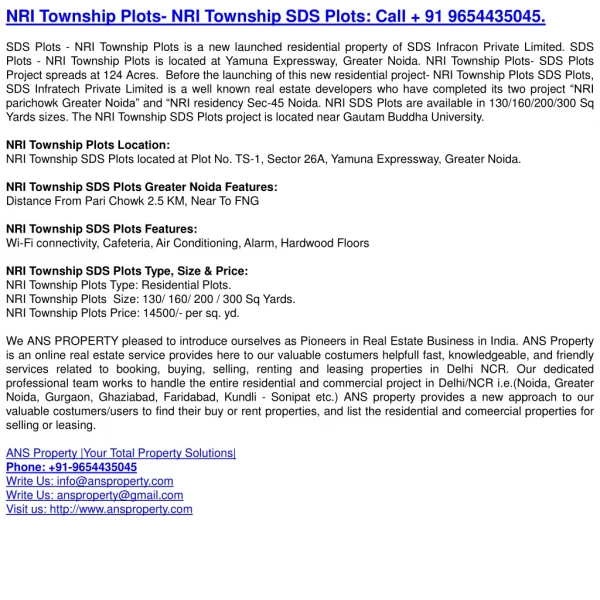
Download
1 / 43
490 likes | 661 Views
The National Resources Inventory (NRI). Is a statistical survey, based on well-established scientific principles Designed & implemented to assess conditions & trends of soil, water, & related resources on non-Federal rural lands

E N D
The National Resources Inventory (NRI) • Is a statistical survey, based on well-established scientific principles • Designed & implemented to assess conditions & trends of soil, water, & related resources on non-Federal rural lands • Conducted for USDA, by NRCS, in cooperation with the Iowa State University Statistical Laboratory
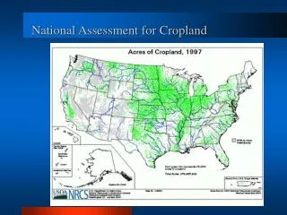
The National Resources Inventory (NRI) • Captures data on land cover & use, soils, soil erosion, wetlands, habitat diversity, selected conservation practices, & related resource attributes -- at 800,000 scientifically selected sample sites • Purpose: To provide support for • Agricultural& Environmental Policy Development and Program Implementation
CONTINUOUS NRI • NRI 5-Year Cycles – 1982,1987, 1992 & 1997 • In 2000 we converted from 5-year inventory to a continuous annual inventory • The continuous annual inventory design: - 73,000 PSUs/year by remote sensing -14,000 PSUs by onsite methods.
Grazing Lands • Nonfederal Grazing Lands • 45% of all nonfederal lands (*) • Rangelands • > 40% of all lands in Nation (#) * Excludes Alaska & Federal lands # Includes Alaska & Federal lands
National Academy of Sciences ISSUES: • Disagreement over status of rangeland, over analysis and assessment techniques, over extent of problems, etc. • Recommendations to DOI and USDA included implement a coordinated & statistically valid national inventory to periodically evaluate health of Federal and nonfederal rangelands • NRI is statistically valid for nonfederal range but proper data are not being collected
Plans • Establishment of Analysis Team – concern re “Continuity and utility of data” (STC) • Make sure we can monitor and look at trends over time • Make sure that we can and do utilize all data • Agency implementation of rangeland field protocols • Many pilot studies; inter-agency development • Federal government – National Cooperative Rangeland Study – DOI, USDA, SRM, others • Conservation Effects Assessment Project (CEAP)
NRI Rangeland Assessment - Objectives • In addition to the usual NRI objectives as stated in policy, use of the NRI (rangeland) field protocols will provide data that: • can be used to further range science • provide more knowledge about interactions among environmental, soil, and plant variables, and management practices
Scientific Requirements – for NRI Rangeland Data • Continuous NRI • To be conducted on the basis of rigorous, scientifically developed sample survey (e.g., statistical) principles and protocols [Policy] • Features prescribed mixture of data collection types [on-site; PI; satellite] & full QA program • Timely, credible, useful data • Move from qualitative/subjective measures to quantitative/objective [National Academy]
Sample Design for Field & Special Resource Studies • Use photo-interpretation sample • First phase in multi-phase design • Use historical information to design sample • Borrow strength from photo-interp data in estimation • Often requires extra stage in sampling • Reduce study costs by selecting geographic clusters • Example: select counties within states first, then PSUs
NRI Rangeland Data Collection, NRCS • 2003 Data Collection • Preceded by a number of pilots in association with personnel from BLM/FS/USGS. • Part of 3-year effort • The 2003 data can not be used by themselves to obtain statistical estimates • 2004 and 2005 data collection • On-site data collection • Standard facet of NRI; Monitoring • Continue to work with other agencies and to pursue remote techniques
2003 Sample/Non-Federal • 2003- Pilot Year • 600 Primary sampling units • Across 110 counties in 17 states • 2004 and 2005 • 2400 Primary sampling units/each year • 19 States
Rangeland Inventory Oracle Data base (Source for historical data and storage for new submitted data) Front end machines Modem bank or Network access to mobile device • PSU and associated historical to mobile computing device • New data uploaded from mobile computing device • All via modem or network connection
Computer-Assisted Survey Information Collection • Hand-held pen-based computer • controlled input formats & navigation • edit checking • communication w/ central server &other peripherals • Central warehouse • sample data base, process metadata • web pages: survey progress, interactive training, data views, instructions
CASI- (Computer Assisted Survey Instrument) • Paper worksheet with embedded rules, logic and communication capabilities. • Key to high quality data
Equipment/Software • Apple Newton Message Pads • Model 2000/2100 • Modem or Network connection* • CASI (Range02.pkg) • Rockwell PLGR (GPS) • Cables, backpack • Some specialized equipment (cover pole, soil stability test kit, tapes etc.)
PSU Data/General • Entry for data collection team members and job titles. • PSU ID information displayed for information.
Gap Examples Basal gaps Canopy gaps
Cover Pole B Transect line Viewing pole A Y 39.4” offset X