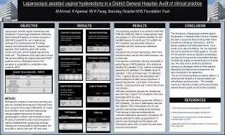
Download
1 / 21
210 likes | 314 Views
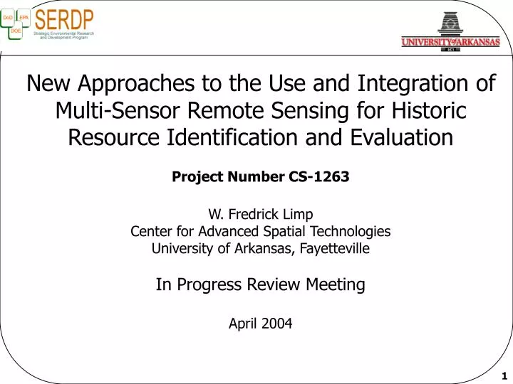
New Approaches to the Use and Integration of Multi-Sensor Remote Sensing for Historic Resource Identification and Evaluation Project Number CS-1263 W. Fredrick Limp Center for Advanced Spatial Technologies University of Arkansas, Fayetteville In Progress Review Meeting April 2004.

E N D
New Approaches to the Use and Integration of Multi-Sensor Remote Sensing for Historic Resource Identification and Evaluation Project Number CS-1263 W. Fredrick Limp Center for Advanced Spatial Technologies University of Arkansas, Fayetteville In Progress Review Meeting April 2004
Technical Objective • Exploration and assessments of the application of innovative fusion methods to a suite of ground, aerial and space-based sensor data for the • detection and identification of surface and subsurface archeological features • identification of best modality and modality mixes • development of COTS based multi-instrument fusion software capabilities
Technical Approach Project Initiation Assessment matrix Instrument/condition Instrument combo Modality worth Software Publications Analysis Assessment Software Enhancement Aerial & Satellite Data Acquisition Archeological Field Testing Initiate Preliminary Analysis Using Existing Datasets Limited additional geophysical acquisition Field Work - Geophysical Data Acquisition Data Analysis Fusion Software Development Design and Populate GIS Databases Raw Data Pre-processing
Technical Approach Data Acquisition at Project Initiation (geophysical, thermal, optical) A = Acquire, E = Existing NA = Conditions not appropriate All proposed efforts have been coordinated w/ installations by Hargrave at USACE/CERL
From our QPR… T1. Installation Coordination T2. Acquire aerial, thermal and satellite data Acquire thermal data at Ft Benning Acquire thermal data at Savannah River T3. Geophysical fieldwork Ft. Bliss completed T4. Preprocess data sets Satellite imagery Ft. Bliss geophysical data Ft. Bliss ATLAS Ft. Benning geophysical Savannah River geophysical Ft. Riley thermal Accomplishments Processing of initial thermal data has yielded substantial problems with data quality including low dynamic range and jitter in frame grabber. Development of new processing approaches and acquisition of new recording device are anticipated to correct problems and acquisition is to be repeated (at no cost to project). A second attempt to acquire imagery on 3/27/2004 was unsuccessful due to aircraft platform instability from high winds. The sensor properties require a very slow flight speed. A third no-cost re-flight is planned.
T5. Establish GIS databases Ft. Riley, Ft. Benning, Savannah River, Ft. Bliss T6 Data Analysis and Fusion Multivariate/statistical fusion Ft. Benning Savannah River Ft. Riley Image segmentation and object classification Whistling Elk First milestones scheduled for completion later in 2004 Accomplishments (2)
Accomplishments (3) • T7. Technology Transfer/Publications • Scheduled as a Year 3 task • To date presentations at Society for Historic Archaeology, • Plains Conference, Society for American Archaeology, Arkansas Academy of Sciences • T8. Archeological Investigation • Year 3 Task/milestones
Resistivity Magnetic Susceptibility Magnetic Gradiometry GPR – Radar Then – Now Preliminary Data Fusion with Principle Components Analysis RGB Composite of PCAs Ft. Riley – Army City WW I
Kasita Magnetometry Kasita Radar Kasita Town Resistivity Very preliminary data processing
Silver Bluff Magnetometry Silver Bluff GPR Silver Bluff Resistivity Very preliminary data processing
ACTION ITEMS NONE
FY 05 Program Plan In FY 04 $ - Combines elements of original Year 2 + Year 3 Task 3. Geophysical Fieldwork $ 29k Task 6.Data Analysis and Fusion $ 127k Fusion Analysis/Modality Worth $ 86k Task 7. Technology Transfer $ 14k Task 8. Archeological Investigations $ 138k Task 9 . Conyers Consulting $ 1.2k Task 10. Technical reports/conference $ 16k Total $412K
Program Plan Task Year 3 Year 1 Year 2 Installation coordination Acquire aerial & satellite data Geophysical fieldwork Preprocess data sets Establish GIS databases Data analysis & fusion Develop field testing program Archeology field testing / validation Project analysis, evaluation, reporting Conferences and reporting
Program Plan Detail Year 3 Calendar 2004 Calendar 2005
Program Funding UA CERL NASA $K $K $K FY03 Installation coordination 6.1 Geophysical fieldwork 6 (Geoscan sub) Thermal data acquisition 4.5 6.1 Preprocessing of data sets 17.7 6 (Geoscan sub) Data analysis & fusion 40.8 Conyers consulting 3 Conference attendance, rpt prep. 16.3 Total 102 FY04 Archeological fieldwork 138.4 Geophysical fieldwork 29.3 Data analysis & fusion 73.3 53.6 (SRI sub) Conyers consulting 1.2 Fusion analysis, modality worth 49.2 36.9 Technology transfer 14 Conference attendance, rpt prep. 16.4 Total 412
Transition Plan • Installation specialists through the USACE-CERL report series and individual efforts of Dr. Hargrave • Traditional scholarly publication and meeting presentations • UA SERDP New Approaches Website http://www.cast.uark.edu/cast/serdp • North American Database of Archeological Geophysics (NADAG) http://www.cast.uark.edu/nadag/. • On-line system supported by the National Center for Preservation Technology and Training • Central source of surface remote sensing data in the U.S. • Commercial partners • Geoscan • SRI • Use of COTS solutions • Definiens Imaging • ESRI
Technical Backup • Technical Backup