Download
1 / 22
220 likes | 227 Views
Learn about the anatomy of hurricanes, including their formation and dissipation, as well as their movement patterns. Understand the differences between hurricanes and midlatitude storms and discover some notable hurricanes throughout history.

E N D
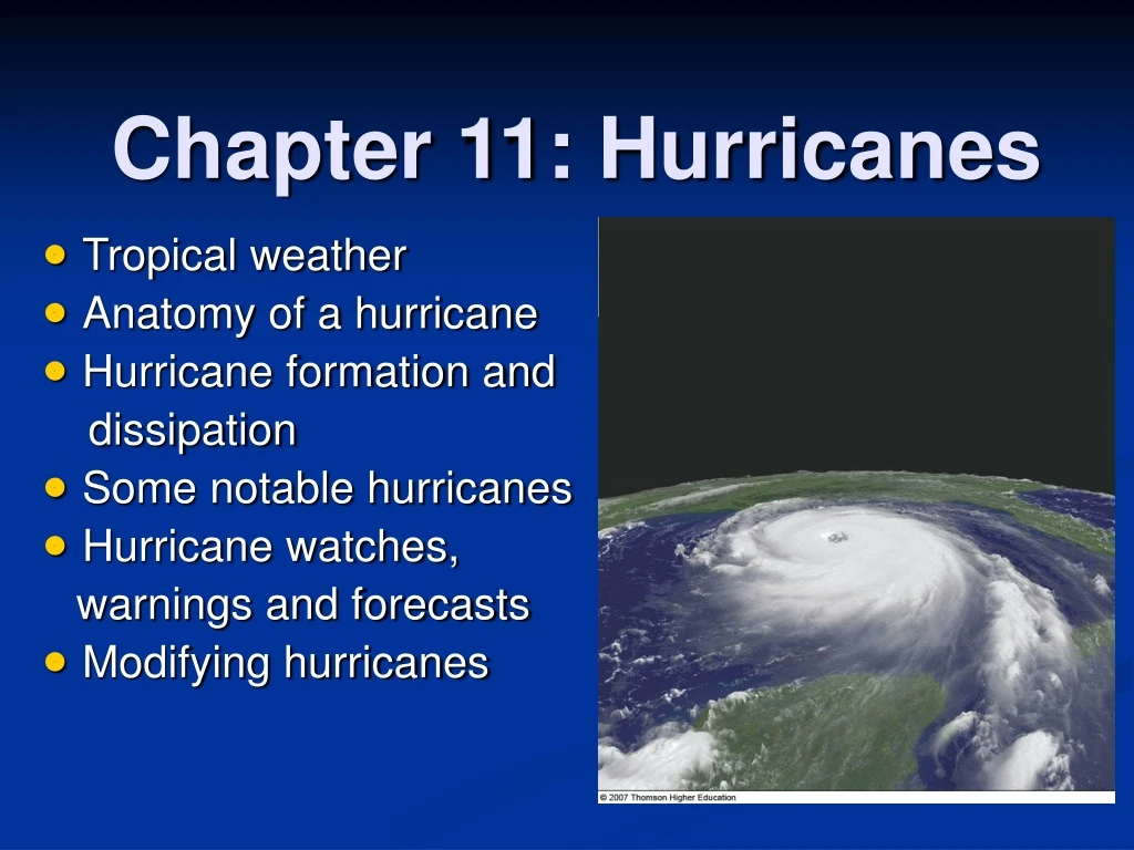
Chapter 11: Hurricanes • Tropical weather • Anatomy of a hurricane • Hurricane formation and dissipation • Some notable hurricanes • Hurricane watches, warnings and forecasts • Modifying hurricanes
Tropical Weather • Tropics: 23.5N-23.5S • streamlines • tropical wave easterly wave, 2500 km wavelength, 10-20 knots speed Q1: Why is there a convergence east of the trough? A: because SE flow converges with NE trade wind. • The tropics are close to the equator, where the Coriolis force is too small to balance the pressure gradient force. Thus winds are not geostrophic, and instead of isobars, streamlines are used
Anatomy of a Hurricane • hurricane (typhoon, cyclone): > 64 knots • eye; eyewall • spiral rain band • Hurricanes are quite similar to, yet also quite different frommid-latitude storms. Q2: 1 knot equals a) 1 km/hr b) 1 mile/hr c) 1 nautical mile/hr
Q3: What would be your experience if you cross a hurricane? A: heavy rain, followed by no rain; very heavy rain and very strong wind near eyewall, followed by clear sky in the eye due to high pressure aloft; very heavy rain near the eyewall again with the reverse of wind direction
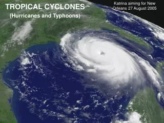
Hurricane Formation and Dissipation Hurricane forms over tropical waters where winds are light, humidity is high in a deep layer, and surface temperature is warm, typically 26.5C (80F) or greater, over a vast area SST > 28C Over Atlantic; Peak in early September
The Right Environment • Convergence trigger ITCZ, easterly waves, midlatitude fronts to tropics • Weak trade wind inversion • Weak upper wind e.g., during a La Nina event (for more hurricanes over Atlantic) • Some Coriolis force: 5-20deg latitude Q4: Why are relatively strong temperature inversion and strong wind shear required for supercell? A: weak inversion would lead to ordinary thunderstorms only and weak wind shear would self-destroy the storm by downdraft. Q5: Why are weak inversion and weak upper wind are required for hurricanes? A: warm ocean surface is the energy source that is not much affected by downdraft; strong inversion prevents the formation of thunderstorms; strong wind disrupts the organized pattern of convection.
The Developing Storm • Heat engine: heat taken at high T, converted into work, then ejected at low T. • Hurricane: heat taken from warm ocean, converted into kinetic energy (wind), lost at its top through radiational cooling • Maximum wind depends on surface and tropopause temperature difference and the potential of sea surface evaporation Q6: With global warming, increased ocean surface evaporation would tend to a) increase hurricane strength, b) decrease hurricane strength, c) not change hurricane strength
The Storm Dies Out • cutting off the storm’s energy supply by moving over cooler ocean • Landfall: lose energy source and increased friction to reduce wind A B C D Q7: In the figure, which storm is dying out? a) storm A, b) storm B, c) storm C, d) storm D Q8: How to draw the vertical distribution of isobars associated with a hurricane? A: minimum surface pressure at hurricane center; high pressure near tropopause at center (see the drawing in class).
Hurricane Stages of Development • tropical disturbance: unorganized mass of thunderstorms, weak wind • tropical depression: 20-34 knots, closed isobars • tropical storm: 35-64 knots, with a name • hurricane: > 64 knots, with a name • This progression of stages is followed in reverse order as a storm weakens. Q9: Where does the strongest wind occur in a hurricane? a) in the hurricane eye, b) around the eyewall, c) in the spiral rain band
Q10: Hurricanes can form over oceans with surface temperature a) > 17 C, b) > 22 C, c) > 27 C Q11: Do usually hurricanes form at the equator? a) yes, b) no Q12: Hurricane wind is stronger than a) 34 knots, b) 44 knots, c) 54 knots, d) 64 knots Q13: Favorable conditions for hurricane development include a) strong inversion and strong upper wind b) strong inversion and weak upper wind c) weak inversion and strong upper wind d) weak inversion and weak upper wind
Hurricane vs midlattitude storms Q14: What do hurricanes and midlatitude storms have in common? A: both are low pressure systems with counterclockwise motions (in Northern Hemisphere). Q15: What do they differ in energy source? A: hurricanes derive energy from warm ocean and latent heat of condensation; while midlatitude storms derive energy from horizontal temperature difference Q16: What do they differ in other aspects? A: 1) warm core low, high center aloft, and sinking air in the eye for hurricanes (versus cold core low, intensifies with height, and rising air at center); 2) strongest wind near surface in hurricanes (versus strongest wind aloft in the jet stream); 3) stronger wind and smaller size in hurricanes
Hurricane Movement • role of the ITCZ • northward movement due to subtropical highs • influence of the westerlies Q17: Westward-moving North Atlantic hurricanes often take a turn towards the north as they approach North America, because of a) the Bermuda High, b) easterly wave, c) westerly wind
Q18: Why is there a lack of hurricanes adjacent to South America? A: because of cooler water, vertical wind shear, and unfavorable ITCZ position. Fig. 11-10, p. 307
January Fig. 7.22 (a) July Fig. 7.22(b)
Naming Hurricanes and Tropical Storms • past practices: female names • current protocol: female and male names; in alphabetic order so that the first hurricane starts with the letter A; then in Greek alphabet • Letters Q, U, X, Y not used over north Atlantic • Letters Q, U not used over north Pacific • Whenever a hurricane has had a major impact, any country affected by the storm can request that the name of the hurricane be retired by the World Meteorological Organization.
Devastating Winds and the Storm Surge Q19: The strongest hurricane wind is located at the place where the hurricane rotational wind and the hurricane movement wind are: a) in the same direction, b) in opposite direction, c) perpendicular to each other Q20: Does the Ekman transport increase or decrease the coastal sea level in the figure? a) increase, b) decrease, c) no effect Q21: What would cause high ocean at the center? a) surface low pressure, b) high pressure
Devastating Winds and the Storm Surge • High waves would raise sea level • Ocean tides (due to gravity of sun and moon) also raise sea level Storm surge (i.e., sea level rise by several meters) could be caused by the combination of Ekman transport, low pressure, high waves, and tides Flooding: due to heavy rain and storm surge; cause most human casualties
defined primarily based on wind speed Table 11-2, p. 313
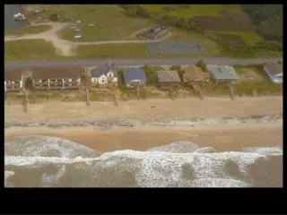
Katrina, 2005: $75B damage; >1300 deaths; High winds, large waves, and large storm surge caused disastrous breeches in the levee system Figure 4, p. 319
Hurricane Watches, Warnings and Forecasts • Hurricane watch: 24-48 hr before landing • hurricane warning: storm will strike an area • Forecasts: improvement in path; not in strength • Wrong forecasts also cause economic loss
Modifying Hurricanes • cloud seeding to reduce maximum wind attempt to increase ordinary thunderstorms (rather than severe thunderstorm in a hurricane; difficult to verify the effect • monomolecular films attempt to reduce surface evaporation; difficult to verify the effect