Download
1 / 1
20 likes | 181 Views
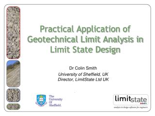
IHG: an Integrated Hydrological-Geotechnical model for large landslides’ susceptibility assessments R. Passalacqua and R. Bovolenta (passalacqua@dicat.unige.it; bovolenta @ dicat.unige.it ) Dept. Civil, Environmental and Architectural Eng.rg - University of Genoa (Italy) .

E N D
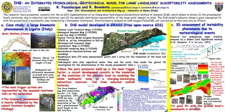
IHG: an Integrated Hydrological-Geotechnical model for large landslides’ susceptibilityassessments R. Passalacqua and R. Bovolenta(passalacqua@dicat.unige.it; bovolenta @dicat.unige.it) Dept. Civil, Environmental and Architectural Eng.rg - University of Genoa (Italy) European Geosciences Union General Assembly 2012Wien (A), 22 – 27 April 2012 Session NH3.6-Poster 11233 The research, here presented, consists into the on-GIS implementation of an Integrated Hydrological-Geotechnical method of analysis (IHG), which allows to obtain (1) the groundwater level’s variations, due to selected rain histories, and (2) the spatially distributed susceptibility of the loose-soils’ deposit to slide. The IHG model’s behavior shows a good conceptual fit with the ground level's movements, also rendered by a Permanent Scatterers'Interferometry analysis on SAR images (PSInSAR), yet carried out on this very site by Others. c. 3D assessment of instability phenomena due to meteorological events a. Case study: a large kinematic phenomenon in Liguria (Italy) b. IHG model developed in GRASS (free open-source GIS) • Contour Level Technical Maps (1/5’000) • Geological Regional Map (1/25’000) • Land Use Map (1/25’000) • Digital Terrain Model (original Resolution 20x20 m, ad hoc interpolated to 5x5 m) • Reckoned and Assessed Slope • Instabiities’ Map (1/10’000) Ground level Santo Stefano d’Aveto Classicalbutwidespreadslopestabilityanalysesby a Global LimitEquilibriummethod (A.W. Skempton – F.A. De Lory, 1957): Steady groundwater table • PSInSAR rendering Map (1/10’000) • Geotechnical characterizations and • soundings • Geophisycal data (70 noise measurement points and 1 array for the evaluation of the loose soil thickness) • Hidrological data (the superficial water flow and the water flow inside the glacial till investigated for the determination of the steady groundwater table ). Map of Liguria and View of the site Bedrock • Ground level IHG model(resolution: 5m) • Groundwatertable (influencedby the rainhistory) mz z Pliocenic GlacialTill (Covered Area 5 km2 ;Lenght 4,5 km) • Element base (variable in the loosesoilstratum) Typical slice W • Foranyrainhistory, the calculationisdone on a total of 29875 pixels and two iterative processes are performedforeach pixel q • Since the porepressuresbuild-upis the main trigger factor, a recentdevelopmentconsists in the simulationof the evolutionsof the phreatic levelbymodeling the wholesediments' body as a charging-dischargingsubsurfacereservoir, fedfromselectedrainfallhistories. Widespread and differential movements at ground level cause damagements to many buildings and structures. • (for a total of 7785713 operations). • The overallcomputational timeisabout 1 minute. • The main trigger actions are represented by the seasonal rain/snow falls on the watershed. The Curve Numbers' map [SoilConservation Service- U.S. Dept. ofAgriculture, 1972- 1975] hasbeenrealisedby the observationof the site's georeferenced aerialimages on the GIS interface. • References • PASSALACQUA R., BOVOLENTA R.: “Integration of spatially distributed data for the 3D modelling of a kinematic phenomenon in Italy”, Proc. of the IAMG (International Association for Mathematical Geosciences) 2011 Conference, 5-9 september 2011, pp. 111-119, University of Salzburg, Austria. • PASSALACQUA R., BOVOLENTA R.: “Characterization and study of a complex landslide site in Northern Italy”, Proc. of The Second World Landslide Forum, held at F.A.O. (United Nations) Headquarters, Rome, 3-9 october 2011, to be published by Springer-WerlagEd.s (in press). • BOVOLENTA R., PASSALACQUA R.: “A 3D model in GIS for the analysisof a kinematicphenomenon in Liguria (Italy)”, Convegno GEOITALIA 2011, VIII° FIST Forum, 19-23 Settembre, Torino. • FEDERICI B., PASSALACQUA R., BOVOLENTA R.: “Realizzazione di una piattaforma GIS per l’analisi di un esteso fenomeno cinematico in Liguria”, Proc. 15th Conferenza Nazionale ASITA, Reggia di Colorno (PR), 15-18 november 2011, Federazione Italiana delle Associazioni Scientifiche per le Informazioni Territoriali ed Ambientali - Milano, pp. 1003-1014. CN Example of susceptibility map and observed damages • The kinematic phenomenon is heavily influenced by the subsoil features (complex lithology). • A good fit with the ground level's movements is obtained. Curve Numbers' map (resolution: 5m)