Download
1 / 25
260 likes | 500 Views
Y. Tony Song Jet Propulsion Laboratory. Detecting Tsunami Power / Scale Directly from Coastal GPS Stations for Early Warnings. Collaborators: Bar-Server, Ichiro Fukumori, L.-L. Fu ( JPL ) C. K. Shum, Chan Yi (Ohio State Univ.) Geoff Blewitt (Nevada). Historical Tsunamis.

E N D
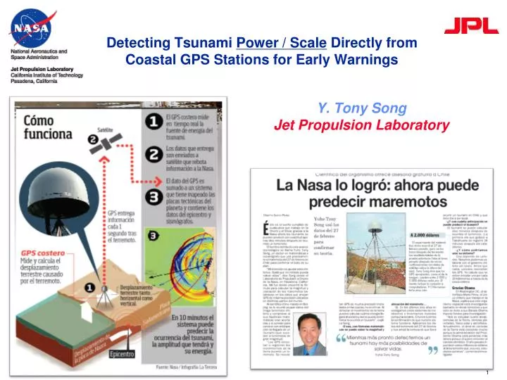
Y. Tony Song Jet Propulsion Laboratory Detecting Tsunami Power / Scale Directly from Coastal GPS Stations for Early Warnings Collaborators: Bar-Server, Ichiro Fukumori, L.-L. Fu (JPL) C. K. Shum, Chan Yi (Ohio State Univ.) Geoff Blewitt (Nevada)
Historical Tsunamis Who parted the Red Sea? Tsunamis (Walter Munk 2000). The first recorded, the Aegean Sea tsunami in 426 B.C. by Greek historian Thucydides (460 – 400 B.C.), who linked it to an earthquake. Tony Song, Jan 2012
Recent Tsunamis Tsunami occurs quite often—the most devastating disaster Tony Song, Jan 2012
Tsunami Characteristics • Tsunami speed: 800 km/hour (jet plane speed) • Wave length: ~ 200 km • Wave height: 20 cm ~ 10 m+ • Reaches shore: 20~30 minutes after an earthquake Are you sure ? Tony Song, Jan 2012
Potential Tsunamis Tsunami is predictable because its pre-cursor (earthquake) can be detected earlier. Tony Song, Jan 2012
Earthquake Detection Zhang Heng (張衡, 78 – 139 A.D.) was an astronomer, mathematician, and poet of the Eastern Han Dynasty in ancient China. He invented the first seismograph in 132 A.D. “Refusing to accept superstitious explanation of the earthquakes, Zhang made heroic observations of earthquakes and invented the ‘Didong Yi’ to detect earthquake from distance” Horizontal pendulum seismograph invented by English seismologist John Milne in1880. Caltech Prof. Charles Richter invented the Richter’s scale of earthquake in 1935.
Current Tsunami Warning System Earthquake-Magnitude-Based Tsunami Warnings(NOAA’s PTWC) Unfortunately, earthquake magnitude is not a good indicator of a resulting tsunami; DART system was not designed for early warnings. Tony Song, Jan 2012
Has the earthquake-magnitude-based approach worked ? Let’s see the fact Example 1: The 2004 Sumatra M9.2 earthquake and Tsunami December 2004 • Fact: • About 230,000 people died due to the tsunami. • Initial estimate of the EQ M8.2 was incorrect (too small). • No tsunami warning was issued. Tony Song, Jan 2012
February 2010 Example 2: The 2010 Chilean M8.8 Eq and Tsunami • Fact • Initial estimate of the EQ M8.8 was correct. • A basin-wide tsunami warning was issued, and some costal communities in Hawaii and Japan were evacuated. • However, no damaging tsunamis observed in those far-field regions. CNN reporting, 27 Feb, 2010 Tony Song, Jan 2012
March 2011 Example 3: The 2011 Japan M9.0 Eq and Tsunami • Fact: • Initial estimate of the EQ M8.0 was incorrect. • Tsunami warning was issued. • Still, about 20,000 people died due to the tsunami. • “Had the magnitude been correctly estimated initially, more lives could have been saved “[Ando et al. 2011]. Summary: Earthquake magnitude is not a good indicator of a resulting tsunami. Tony Song, Jan 2012
A New Tsunami Theory Song et al., The role of the horizontal impulses of the faulting continental slope in generating the 26 December 2004 tsunami, Ocean Modell. [2008]. Courtesy Chen Ji Energy approach—Potential energy and Kinetic energy Lateral motions of continental slopes transfer the major tsunami energy Tony Song, April 2010
TOPEX/Poseidon Grace Evidence from satellites Vertical uplift was not the only cause of the 2004 tsunami (Song & Han 2011) Launched 2002 Sea Surface Height Seafloor uplift Song, Y.T. and S.-C. Han (2011) Tony Song, April 2010
A New Tsunami Detection ApproachSong, Y.T., Detecting tsunami genesis and scales directly from coastal GPS stations, GRL, 34, (2007). Tony Song, April 2010
A Pilot NASA Project GPS-aided Real-Time Earthquake and Tsunami (GREAT) Alert System Team Leader: Yoaz Bar-Sever (JPL) JPL/ NASA Richard Gross, Tony Song, Frank Webb Pacific Tsunami Warning Centre / NOAA Vindell Hsu USGS Kenneth Hudnut University of Nevada Reno Geoff Blewitt, Hans-Peter Plag California Institute of Technology Mark Simons Tony Song, April 2010
Real-Time Test 1:Chile M8.8 Earthquake Demonstrates GPS method (a): NASA's Global Differential GPS (GDGPS) measures the Chile M8.8 earthquake displacement in real time at Santiago. (b): JPL team predicts a moderate sized tsunami using the real-time GPS and the Song tsunami generation model. (c): NASA/CNES satellites Jason-1 and Jason-2 confirm the tsunami amplitude of the GPS-based model prediction. Next steps: Strengthen real time GDGPS network, automate models. Tony Song , Yoaz Bar-Sever, et al /JPL Tony Song, April 2010
Test 2 (after event):2011 Tohoku-Oki M9.0 Earthquake & Tsunami GPS-based Tsunami Prediction System Song, et al., GRL, 2012 ARIA/JPL Tony Song, April 2011
Model simulation of the March 11, 2011 tsunami, generated from 1,200 GPS offset data and synchronized with actual satellite tracks (Jason-1 and Jason-2). Matching Models With Satellite Data Tony Song, Dec 2011
Track1 observed tsunami height ~30 cm Matching Models With Satellite Data NASA’s Jason-1 satellite was at the right place at the right time and observed the merged waves Data Model Track2 observed tsunami height ~70 cm Track3 observed tsunami height ~30 cm Tony Song, Dec 2011
Detect Tsunami Scales • Procedure: • Collect GPS displacement in real time • Model the seafloor motions • Estimate Tsunami Energy/Tsunami Scale (Song 2007): Tony Song, June 2011
SummaryGPS Detection of Tsunami Scales for Early Warnings We have developed an innovative approach to detect the triggers of tsunamis and tsunami scales using real-time GPS network. Based on the new approach, we have successfully tested some GPS stations on the 2010 Chilean tsunami and 2011 Japanese tsunami. Tony Song, Jan 2012
The Good NewsGPS detection tsunamis was ranked as Top 100 Science Stories of 2010 Katerva identifies the best ideas on the planet and accelerates themtoward impact at the global level. http://katerva.org/the-katerva-awards Tsunami Detection, nominated, entered finalist, then runner up for the 2011 Katerva Award in Human Development category Tony Song, Jan 2012
The Bad News Many challenges ahead • Need NASA, NOAA, USGS, academic, and Industry collaborations to develop a universal data system ( working with Chile, China, Japan, GDGPS). • Need an automation system to response earthquakes and tsunamis (developing at JPL). • Need more research on tsunami genesis. Tony Song, Jan 2012
Two Implications • Near-field forecast:Coastal GPS is a solution. For example, the initial seismic estimate of the March 11, 2011 earthquake was significantly smaller. Had the magnitude been correctly estimated initially, more lives could have been saved [Ando et al. 2011]. • Far-field Forecast: No large-scale panic is necessary, but need to identify those regions in the direction of the merging tsunamis (which are predictable). Tony Song, Dec 2011
On Going Tsunami Research Project 2, NASA Decision $1.1M: GPS-aided Real-Time Earthquake and Tsunami (GREAT) Alert SystemJPL (Bar-Sever, Gross, Song, Webb)USGU (Hudnut)NOAA’s PTWC (Hsu) Caltech (Simons) UNR (Blewitt, Plag) (Needs multi-disciplinary effort: Seismology, Oceanography, GPS technology, and Computing) Project 1, JPL R&TD $150K: Demonstrating a Coastal GPS Network for Directly Detecting Tsunami Genesis and Scales Existing GDGPS (JPL/NASA) Add into GDGPS Project 3, NASA Disasters Program $150K: GPS-aided and DART-ensured tsunami detection system. Tony Song, May 2008
A Global GPS NetworkGPS-Aided Tsunami Early Detection (GATED) System Tony Song, Dec 2011