Download
1 / 37
370 likes | 500 Views
Real-time integration of remote sensing, surface meteorology, and ecological models. Goals. Provide Nowcast/Forecasts of water and carbon cycle variables for the conterminous United States with the Terrestrial Observation and Prediction System (TOPS). Need for integration.

E N D
Real-time integration of remote sensing, surface meteorology, and ecological models
Goals • Provide Nowcast/Forecasts of water and carbon cycle variables for the conterminous United States with the Terrestrial Observation and Prediction System (TOPS)
Need for integration • Integration of remote sensing, surface meteorology, and ecological models provides the best opportunity for comprehensive assessment of the state and activity of landscape processes • Disciplines are traditionally separate but can be highly complementary
Remote sensing alone … • Useful for describing short- and long-term variation in terrestrial vegetation • Photosynthetic activity, leaf area index, absorbed radiation • Phenological development • Land use and land cover changes • Less useful for detecting plant stress and hydrologic cycles
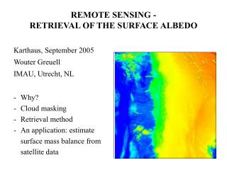
Surface meteorology alone ... • Provides critical information needed to describe land-atmosphere interactions • Inadequate for assessment of landscape processes
Prognostic ecological models • Simulate past and future climate scenarios • Mass-balance simulations of carbon, water, and nutrient cycles • Often do not ingest vegetation observations • Thus less useful for real-time management applications
What we need • A non-prognostic ecological model ingesting real-time satellite and surface meteorology observations
TOPS Overview • 1 kilometer spatial resolution • Remotely-sensed leaf area index (LAI) • Rapid Update Cycle meteorology (RUC) • Land surface model (LSM)
Remotely-sensed LAI • Currently: Advanced Very High Resolution Radiometer (AVHRR) • Future: Moderate Resolution Imaging Spectroradiometer (MODIS) • Algorithm • Main: MODIS backup • Cloud contamination: historical averages
RUC-2 • Produced by the National Centers for Environmental Prediction • Hourly outputs • 20 kilometer resolution • Automated scripts gather data and process hourly values to daily values • Future developments will include downscaling algorithms
Downscaling: use of lapse rates and digital elevation model to adjust temperatures within each 40 km pixel Temp = 20 deg C DEM
Ecological model • Based on BIOME-BGC • No complete carbon balance • Forced with observed LAI
Results • Beta version • June 18
Planned transformed variables • Accumulated stress/fire danger • incorporate lightning strike information • Anomalies/departures from normal • Water deficit/irrigation requirements
Forecasts • Six-month goal: incorporate Forecast Systems Laboratory (FSL) short- to medium-term forecasts • seven-day forecasts • one to three month climatological forecasts One year goal: Ingest long-lead forecasts from ECPC/NCEP.
Real-time and forecast modes • Must be run simultaneously • unconstrained use of forecast data leads to catastrophic errors in hydrologic cycles • important for regional scale climate models to accurately parameterize the land surface, especially in the Southwest
Conclusions • Real-time management needs can be addressed with an approach integrating remote sensing, surface meteorology, and ecological modeling • TOPS will provide real-time simulations of water and carbon cycles through a web-based interface within two months • Within six months we will add forecast simulations constrained by current conditions • System is flexible and can be adapted to variable spatial resolutions and inputs