Download
1 / 64
640 likes | 768 Views
Oregon DOT Geometronics Unit Update. Ken Bays Lead Geodetic Surveyor ODOT Geometronics Unit 16 September 2008 CGSIC States & Localities Savannah, Georgia. Mission: ODOT Geometronics Unit. Preserve and enhance geodetic control in the State of Oregon. Overview. Gravity Campaign in Oregon

E N D
Oregon DOT Geometronics Unit Update Ken Bays Lead Geodetic Surveyor ODOT Geometronics Unit 16 September 2008 CGSIC States & Localities Savannah, Georgia
Mission: ODOT Geometronics Unit • Preserve and enhance geodetic control in the State of Oregon
Overview • Gravity Campaign in Oregon • NGS National Gravity Survey Plan • Oregon Gravity Surveys 2007 • Precise Digital Leveling in Oregon • Oregon Real-time GPS Network Update • Outreach/Education
Gravity • NGS National Gravity Survey Plan • 2007 Oregon Gravity Survey
NGS National Gravity Survey Plan • The GRAV-D Project: • Gravity for the Redefinition of the American Vertical Datum • “Accurate gravity data is the foundation for the Federal government’s determination of heights”
Why a Gravity Survey is Needed • “GPS Ellipsoid heights cannot be used to determine where water will flow, and therefore are not used in topographic/floodplain mapping.” • “Orthometric heights are related to water flow and more useful.” • NGS National Gravity Survey Plan
GEOID SEPARATION (GEOID HEIGHT) MEAN SEA LEVEL ELEVATION (ORTHOMETRIC HEIGHT) GEOID SURFACE (MEAN SEA LEVEL) EARTH’S HEIGHT ABOVE ELLIPSOID (HAE) ELLIPSOID SURFACE OCEAN Geoid - Ellipsoid Relationship
Why a Gravity Survey is Needed • “In order to transform from ellipsoid heights to orthometric heights, a model of the geoid must be computed.” • “Geoid modeling can only be done with measurements of the acceleration of gravity near the Earth’s surface.” • NGS National Gravity Survey Plan
Grav-D Project Summary • I. High resolution snapshot • to repair and improve existing gravity holdings • a one-time survey with dense spatial coverage but short time frame (7-10 years) • Rely heavily on airborne gravity • II. Low resolution movie • to track the temporal changes to the gravity field on a broad scale • a re-occurring survey with very coarse spatial coverage and a long time span. • III. Terrestrial Partnership Surveys • to measure and/or track very localized gravity values of particular importance to the fine-scale local determination of heights
Campaign III: Terrestrial Partnership Surveys • “A ‘boots-on-the-ground’ re-check of each place where new airborne gravity surveys disagree with existing terrestrial gravity data” • “In general such surveys are expected to rely heavily upon the partnerships NGS has formed, and will form, through a National Height Modernization program” • “NGS will engage local partners in the surveys, including loaning equipment and providing training in the use of the equipment, and submittal of processed data to NGS.” • “Potential for localized geoid slopes to be directly determined from field surveys of co-located (space and time) leveling and GPS.”
Unit of Gravity Measurements • Gal = 1 cm/sec2 • Named in honor of Galileo Galilei
“Average” Gravity Force on Earth’s Surface • 32 ft/sec2 is “average” force on Earth’s surface • = 9.8 meters/sec2 • = 980 centimeters/sec2 (or 980 Gals) • = 980,000 milliGals (mGals) • Typically, gravity observations are recorded in milliGals , a milliGal is about 1 millionth of the acceleration of gravity at the earth's surface.
The Process • Absolute gravity measured by Dan Winester, NGS • Transfer absolute gravity reading to ground w/relative meter • Transfer absolute ground to Excenter • Search for Old Gravity Stations • Run relative loops from Excenter to previously observed stations (double run)
Absolute Gravimeter • Basically an accelerometer • The descent of a free-falling object inside of the absolute gravimeter is monitored very accurately with an accurately timed laser interferometer • Accuracy: 2 microGal (observed agreement between FG5 instruments)
Relative Gravimeter • A spring used to counteract the force of gravity pulling on an object. • The change in length of the spring may be calibrated to the force required to balance the gravitational pull on the object.
Searching for Gravity Stations • Very Old Poorly Written Descriptions • Many were not Monumented • 100+ Stations to Measure • Lots of Driving and Long Days • Three Months to Complete the State
Precise Leveling in Oregon • Preservation and replacement of Benchmarks in Oregon • Run levels to stations of the Oregon Real-time GPS Network as part of Height Modernization program. • “Potential for localized geoid slopes to be directly determined from field surveys of co-located (space and time) leveling and GPS.” NGS National Gravity Survey Plan
Precise Leveling • Acquired all equipment • First order Leica DNA-03 level • Invar rods • Invar 60 cm strip (for vertical Bm’s) • Thermisters • Turtles • Turning Pins • Acquired Training • NGS Precise Leveling Workshop • Curt Smith, NGS State Advisor tutorial provided on-project training
Stanford Linear Accelerator CenterVertical Comparator for the Calibration of Leveling Equipment • A fully automated vertical comparator for the calibration of digital levels and invar staffs • Developed by the Metrology Department in cooperation with the Institute of Engineering Geodesy and Measurement Systems at the Graz University of Technology. • The vertical comparator was built in 2003 in the SLAC Metrology laboratory
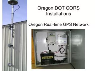
Oregon Real-time GPS Network www.TheORGN.net
Administrator • Oregon Department of Transportation • Geometronics Unit • Program Manager: Ron Singh • Technical Manager: Ken Bays • ORGN Support: Randy Oberg
Administrator Responsibilities • Network quality control • Network software operation • Network software maintenance and upgrades • User support
Major Cooperators & Support • NGS • UNAVCO Plate Boundary Observatory • Washington State Reference Network • Exchange of raw GPS data streams across the Columbia River. • California and Idaho as their networks develops
Partners • Partners will provide sites, GPS equipment, and other major infrastructure to the network. • Government agencies • Inter-Governmental Agreements • Private entities • Public-Private Partnerships
Subscribers • Anyone who is not a partner and wants access to RTK correctors data from the ORGN. • Must have rover account set up • No direct fee at this time • Online rover account application at www.TheORGN.net • May have minimal fee in future to cover operation, maintenance, and upgrades, but not to cover the build of the infrastructure of the network.
Can I Trust the ORGN for Accurate GPS Positions? Installation • Pre-testing of Positions • Extreme Care • Sturdy Antenna Mounts • Carefully Calculated Positions • Constant Monitoring of Antenna Positions • Precise Emphemeris used for Correctors
Site Criteria Standards • 60 Km Station Spacing • Satellite visibility: clear view of sky • No electromagnetic interference • Pre-installation data quality sets: 3 days of GPS data • Continuous power w/ backup • Internet connectivity