Download

1 / 24
250 likes | 406 Views
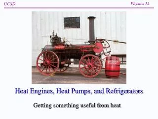
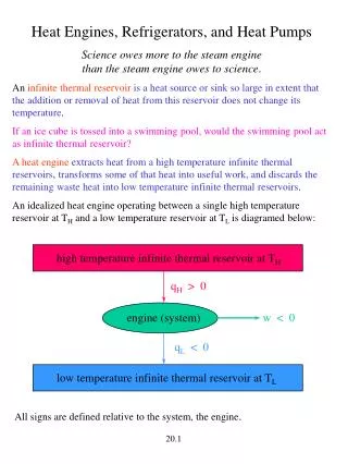
Hurricanes as Heat Engines. Different ways to look at a hurricane. What do you know about hurricanes?. Factors that I nfluence H urricane Formation Warm Sea Surface Temperature Rapid cooling of air as it rises Rotation in a low pressure system Available moisture.

E N D
Factors that Influence Hurricane Formation • Warm Sea Surface Temperature • Rapid cooling of air as it rises • Rotation in a low pressure system • Available moisture
How do we Study Hurricanes at NASA? Satellite swath
What to look for: • Changing sea surface temperatures as shown in the color plots to follow • Length of time it took for the water temperature to change (is there a delay or is there a sudden change in temp?)
Some Background Information: The passage of a hurricane causes a large transfer of heat between the ocean surface and the atmosphere. It also causes surface waters to diverge, bringing cooler water from below to the surface (upwelling). These effects are so large that they can be seen by a drop in sea surface temperature (SST) in satellite data observations along the path of the storm. The cooler water conditions may last for a week or longer after the storm.
Questions Did you see any evidence of lowered sea surface temperature in the data maps? Did you notice any delay between the hurricane passage and the effect on SST?
Lets look at a time series plot for a spot along Rita’s path (Sept 1- Oct 30)
Questions: -Examine the line plot of sea surface temperature for your selected location Can you see the effect on the temperature in your line plot after the hurricane passed? How long did it take for the SST to return to the previous temperature?
Questions What conclusions can you make about how hurricanes extract heat energy from the ocean?
A Quick Wrap-up • As hurricanes move across the water they consume energy in the form of heat from the surface of the water. • There is a lag time after the hurricane moves past and the drop in SST • After the drop in SST there will be a normal rebound back to normal seasonal temperatures
For more information on using satellite data in the classroom visit the MY NASA DATA web site. There you will find a long list of lesson plans, science project ideas and much more. http://mynasadata.larc.nasa.gov/