Download
1 / 32
320 likes | 323 Views
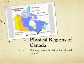
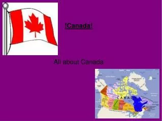
USA/Canada Physical Feature Notes. 6 th Grade Geography. Landforms. Arctic Lowlands. Made up of a series of islands located in northern Canada . Ground stays frozen most of the year. Very few people live there. Queen Elizabeth Islands.

E N D
USA/Canada Physical Feature Notes 6th Grade Geography
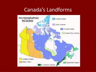
Arctic Lowlands • Made up of a series of islands located in northern Canada. • Ground stays frozen most of the year. • Very few people live there.
Queen Elizabeth Islands • A series of islands located between the Arctic Lowlands and Greenland. • All together, the islands have a population of less than 400 people.
Canadian Shield • Also called the Laurentian Plateau. • Stretches from north of the Great Lakes to the Arctic Ocean. • It covers over half of Canada.
Interior Plains • Located in both Canada and the United States. • The land in this area is typically good for farming. • Western edge runs along the Rocky Mountains.
Rocky Mountains • Runs through both the United States and Canada. • Largest mountain system in North America. • Located in the western regions of both the United States and Canada.
Coast Mountains • A major mountain range in the Pacific Coast Ranges. • Located in along the coast of western Canada.
Mackenzie Mountains • Located in both the Yukon Territory and Northwest Territory. • Named in honor of Canada’s second Prime Minister Alexander Mackenzie.
Appalachian Mountains • Second largest mountain system in North America. • Runs along the eastern region of the United States. • Much of the mountains have lush vegetation.
Hudson Bay Lowlands • Area between the Canadian Shield and Hudson Bay. • Climate is determined by the level of water in Hudson Bay.
Labrador Peninsula • Large peninsula in eastern Canada. • Bordered by the Hudson Bay, the Hudson Strait, the Labrador Sea, and the Gulf of St. Lawrence.
Baffin Bay • Located between Baffin Island and Greenland. • Most parts of the year boats are not able to navigate this body of water due to the ice coverage and/or icebergs.
Davis Strait • Named for explorer John Davis. • It is famous for its fierce tides that range from 30 to 60 feet. • Located near the southern tips of Baffin Island and Greenland.
Labrador Sea • Formed when the North American Plate and the Greenland Plate separated. • 2/3 of the sea is covered in ice.
Atlantic Ocean • East of both Canada and the United States. • Second largest of the world’s oceans. • Covers approximately 20% of Earth’s surface.
Pacific Ocean • The largest of the earth’s oceans. • Covers 1/3 of the earth’s surface. • Currently shrinking due to plate tectonics. • West of Canada and the US.
Bering Sea • Bordered by Alaska and Russia. • Considered to have one of the best ecosystems to support marine life.
Bering Strait • Body of water between Russia and Alaska. • About 53 miles wide.
Lake Superior • Largest of the Great Lakes and largest freshwater lake. • Bordered by Ontario, Minnesota, Wisconsin, and Michigan.
Lake Michigan • The only Great Lake that is located entirely in the US. • Second largest Great Lake according to water volume. • “Michigan” comes from an Ojibwa word meaning “great water”.
Lake Ontario • Ontario, Canada’s most populated province, was named for it. • Bordered by Ontario and New York. • Serves as an outlet to the Atlantic Ocean through the St. Lawrence River.
Lake Erie • The outflow from the lake provides hydroelectric power to Canada and the U.S. as it spins huge turbines at Niagara Falls. • It is the shallowest of the Great Lakes.
Lake Huron • The 2nd largest Great Lake and 3rd largest freshwater lake in the world. • Named after the Huron people who lived in the surrounding area.
Mississippi River • Largest river system in North America. • The name came from an Ojibwa word meaning “great river”. • Runs through 10 states and was used to help form state borders. • Runs from Minnesota to the Gulf of Mexico.
St. Lawrence River • Connects the Great Lakes to the Atlantic Ocean. • Drains into the Gulf of St. Lawrence.
Gulf of St. Lawrence • The world’s largest estuary. • The outlet of the Great Lakes from the St. Lawrence river to the Atlantic Ocean.
Yukon River • Runs through Alaska and the Yukon Territory. • The Yukon Territory was named after the Yukon River.
Gulf of Alaska • The entire shoreline of the Gulf is a rugged combination of forest, mountain, and a number of tidewater glaciers. • It is the generator of storms that drop snow and ice on Alaska.
Beaufort Sea • Located north of Alaska, the Yukon Territory, and the Northwest Territory. • The sea is characterized by severe climate and is frozen over most of the year.
Hudson Bay • Large body of saltwater in northeastern Canada. • It is largely frozen over from mid-December to mid-June. • Surrounded by the Hudson Bay Lowlands.