Download
1 / 30
300 likes | 302 Views
Overview of the RAINEX project and its modeling of hurricanes, focusing on the internal dynamics, concentric eyewalls, vertical wind shear, and moisture distribution. The use of airborne radar and dropsondes to observe and analyze hurricane structures is discussed. High-resolution numerical models and their forecasts are examined, along with the effect of environmental influences on storm intensity.

E N D
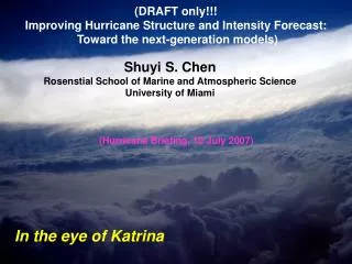
Overview of RAINEX Modeling of 2005 Hurricanes Shuyi S. Chen Rosenstial School of Marine and Atmospheric Science University of Miami In the eye of Katrina
Environment RainbandsInner Core Hurricane Internal Dynmaics • Inner core and rainband internactions • Concentric eyewalls and eyewall replacement cycle • Vertical wind shear • Moisture distribution
Use airborne Doppler radar to observe both eyewall and rainband internal vorticity structures simultaneously • Use intensive dropsondes for thermodynamic environment of hurricane rainbands and eyewall to support both analysis and modeling/forecasting • Use model to determine how the rain, wind, vorticity, features evolve and storm intensitychanges
Katrina Ophelia Rita
High-ResolutionMulti-nested Vortex-Following Numerical Models at University of Miami: 15 km • UM/RSMAS Coupled Atmos-Wave-Ocean Model • Weather Research and Forecast (WRF) Model 5 km 1.6 km Mini ensemble MM5 and WRF forecasts using GFS, NOGAPS, CMC, and GFDL forecast fields as initial and lateral boundary conditions
8/28 8/27
9/21 9/22 9/19 9/20 9/23
ELDORA composite reflectivity in Rita on 22 Sept 05 MM5 Rainrate in Rita on 22 Sept 05
N43 flight-level wind in Rita Inner outer outer Inner Observed MM5 22 September 2005 Inner Radar Reflectivity outer WRF Eyewall Replacement in Hurricane Rita (2005)
Effect of vertical wind shear on Hurricane Rita structure and intensity Model 5-day forecast
How do concentric eyewalls (or secondary eyewall) form and how do they effect the storm intensity? • Structures of primary eyewall and rainbands (i.e., internal dynamics) • Initial conditions (e.g., background MPV field, etc.) • Environmental influences (e.g., water vapor distribution that may influence rainband strength and orientation, etc.)
Rita “Rita” 1.6 km 5 km Katrina 1.6 km “Rita” Large init vortex
Hurricane Katrina Hurricane Rita 1.6 km 1.6 km “Rita” Rapid intensification 5 km
TMI Total Precipitable Water Katrina Rita 70 60 50 40
Conceptual Model of How Moisture Gradient Affecting to Rainband Organizations Weak Gradient in Katrina Strong Gradient in Rita Moist Dry
Conclusions • RAINEX provided an unique, comprehensive dataset for evaluating and improving high-resolution models. • High-resolution (~1 km, fully resolving the inner core and rainband structures) forecasts in real-time are extremely valuable for mission planning and overall understanding of the storm structure, evolution, and intensity change. • Environmental moisture distribution can have a significant impact on rainband organizations, formation of concentric eyewalls, and eyewall replacement. • Accurate initial and lateral boundary conditions for high-res models are needed. • Need a good data assimilation system for high-resolution model forecasting in real-time.