Download
1 / 43
430 likes | 504 Views
Using Meta-Layers for GIS Dataset Tracking and Management NEARC May 11, 2010. Brian Hebert May, 2010 bhebert@scribekey.com. Presentation Outline. Geospatial Metadata Today Issues and Challenges Using a RDB Metadata Repository (MR) Building and Loading the MR The Geospatial Difference

E N D
Using Meta-Layers for GIS Dataset Tracking and ManagementNEARC May 11, 2010 Brian Hebert May, 2010 bhebert@scribekey.com www.scribekey.com
Presentation Outline • Geospatial Metadata Today • Issues and Challenges • Using a RDB Metadata Repository (MR) • Building and Loading the MR • The Geospatial Difference • Q&A www.scribekey.com
Project Background/Requirements • Generate FGDC Metadata for Large Commercial Data Provider(s) • Helping Federal Agency Collect, Describe, and Deliver Large Datasets • Applies to any large collection of GIS layers, public or private. 200+ Countries 72 Layers 100s of Attributes 100s of Domains Quarterly Updates 50+ States 400 Layers 1000s of Attributes 100s of Domains Annual Updates www.scribekey.com 3
Typical Metadata Workflow • Understand standard(s), XML, UML • Find examples • Use metadata editor • Package metadata with data • End user views metadata with ArcCatalog • Metadata loaded onto server to support search/download www.scribekey.com 4
Geospatial Metadata Standards • FGDC CSDGM 1990 • ISO 19115/19110 NAP 2009 • Both persisted as XML/XSD, rendered as HTML www.scribekey.com 5
Understanding the Standards • Complicated for end users, what’s core? • UML, XSD, Grammar Production Rules • Language and artifacts familiar to professional data modelers, academicians • No separation between logical and physical as typically used in IT solution development ??? www.scribekey.com 6
ISO 19115/19110 Split • FGDC CSDGM included both core metadata about layer and entity, attribute, domain info • ISO 19115 Geographic Information – Metadatadoesn’t include this basic database-centric metadata • 19110 Feature Catalog does contain entity, attribute, domain info, but mixed in with a great deal of other material • Presents a significant challenge to migration, for tool providers and users alike FGDC CSDGM ISO 19115 ISO 19110 Entity Attribute Domain Core Layer www.scribekey.com 7
Provider: Getting the Job Done • Finds examples • Uses ESRI ArcCatalog editor • Packages with data SHP DBF XML GeoDB BLOB www.scribekey.com 8
Consumers: Using Metadata • End users: reviews with ArcCatalog • Applications: Used behind the scenes with GOS, National Map, FGDC, NSDI Nodes www.scribekey.com 9
Challenges/Issues • Learning curve and significant complexity • Designed to describe single layer, not easy to see a layer list • Requires significant manual effort • Different physical format from data • Separated from data being described, synchronization problems • No element to represent non-geometric table data • Difficulty representing multi-source data layers • Difficulty representing feature level metadata • Entity, Attribute, Domain info is optional • Domains don’t exist on their own, no name, definition • No multi-value or hierarchical domains • No attribute percent complete, key, format, nulls allowed, info www.scribekey.com 10
Geospatial Data and Metadata Separation Shape Files File DBF SHP BLOB XML Document Geodatabase Metadata provides an essential ingredient for successful data integration. Geospatial data and metadata are today managed using very different paradigms. Data is managed using RDBMS and metadata is managed using XML. As such, data and metadata are separated, which leads to synchronization problems and a number of other issues. www.scribekey.com 11
Standards Intentions and Physical Implementation • The FGDC/CSDGM standard clearly states that the physical implementation of metadata management is up to the organization. From the CSDGM Workbook: The standard specifies information content, but not how to organize this information in a computer system or in a data transfer, or how to transmit, communicate, or present the information to a user. There are several reasons for this approach: There are many means by which metadata could be organized in a computer. These include incorporating data as part of a geographic information system, in a separate data base, and as a text file. Organizations can choose the approach which suits their data management strategy, budget, and other institutional and technical factors. In spite of these clearly stated intentions, metadata implementation has not been organized using GIS or database technology, but rather as separate text/XML/HTML files. Consider FGDC/ISO XML Metadata output as a database report from the metadata repository, not necessarily as management tool/environment. www.scribekey.com 12
OLTP/OLAP Design Differences and the Middle Tier Presentation Layer Presentation Layer Business Logic Middle Tier Layer UML/XML – OO Language No Middle Tier Data Access Layer Data Access Layer Database Database Production OLTP database solutions typically use a middle tier for representing higher level business objects and rules. This middle tier is often designed using UML and implemented with an Object Oriented programming language. Decision Support OLAP database solutions typically have no Middle tier. They present and access data directly through query language behind pivot tables and report generators. www.scribekey.com 13
Different Flavors of XML XML can use several flavors including relational, object oriented, or a combination of both Relational XML OO XML The UML derived XML used for modeling FGDC and ISO standards leans towards variable length, nested, object oriented structures, easily supported in languages like C#, Java, and C++, but not easy to represent in RDBMS. Typically, in 3 tier solutions there is an object-relational mapping between the persistent relational store and the logical middle tier, e.g., as with ArcObjects and Geodatabases. www.scribekey.com 14
Take a Step Back: Why do we develop metadata? • Rudyard Kipling: The "Five Ws" (and one H) • "Just So Stories" (1902), a poem accompanying the tale of "The Elephant's Child" • I keep six honest serving-men(They taught me all I knew);Their names are What and Why and WhenAnd How and Where and Who • Basics: Areas, Categories, Layers, Attributes, Domains www.scribekey.com 15
Goal: Maximize Understanding of Data FGDC Metadata Data Profiles Data Quality Assessments Cross Referenced Terms Keywords, Aliases, Indexes Table of Contents Glossary Meaning Structure Contents Complete metadata describes Meaning, Structure, and Contents. Maximize understanding by end user and help write applications. Help with variety of data description and integration tasks. www.scribekey.com 16
Solution: RDB Metadata Repository and Tools INVENTORY COLLECTION PROFILING APPLICATIONS ASSESSMENT METADATA REPOSITORY DESCRIPTION VALIDATION CENTRAL RDB STANDARDIZE & MAP Iterative Operations ETL SCHEMA GENERATION www.scribekey.com 17
Benefits: Relational DB Flexibility • GIS end users intuitively understand data tables • Useful for describing large, multi-layer, data holdings, easy to see all layers in a list • RDB applications can be developed for input/output • Same physical format as data • Can live alongside data being described • Can easily represent multi-source data layers • Can easily represent feature level metadata • Entity, Attribute, Domain info is cornerstone • Explicit capture and modeling of domains • Data quality information, percent complete, formats can be easily integrated • Facilitates schema matching www.scribekey.com 18
Table Centric Data Dictionaries/Catalogs Coverage Areas Layers Attributes Domains HTML Relational Metadata Repository supports wide variety of useful outputs for end users and application developers. www.scribekey.com 19
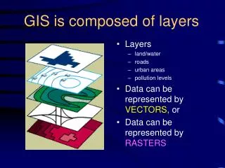
Meta-Layers: Using Metadata as GIS Data Using metadata the same way we use other GIS data allows wide variety of map presentations, reports, etc. to summarize and highlight datasets by metadata values. www.scribekey.com 20
Meta-Layers: Using Metadata as GIS Data (cont.) www.scribekey.com 21
Viewing Meta-Layers in ArcMap FGDC Metadata is stored in the same RDB, integrated with the geospatial data it is describing, and accessible from ArcMap for review, query, and symbolization. www.scribekey.com 22
The Layer-Layer Data Meta-Layer data table includes information describing dataset: coverage area, level of political administration, layer contents, source, quality, publication date, completeness, whether or not FGDC metadata is available, number of records, number of attributes, etc. www.scribekey.com 23
Record Level Metadata • Geospatial metadata describes the group of records comprising a dataset as a single entity. • Some end users want metadata at the individual record level. • FGDC/ISO does not support this granularity. www.scribekey.com 24
Multi-Source Data Layers • Some data layers are the result of a merge between multiple input layers. • To track this, each record needs to carry a link back to the original dataset. • Necessary if swap-out updates are part of workflow. • New ISO 19115 has notion of dataset series. Dataset A Dataset B Dataset C www.scribekey.com 25
Pivot Tables: Standard Biz-Intel Tool • Hierarchical • Drill-down • Aggregates • Easy to Use Sample Pivot Table in MS_Access showing Layer Type, Admin Area, Publication Date, Source, Quality www.scribekey.com 26
Future: Business/Geo-Intelligence Pivot Tables/Maps View and analyze both data and metadata, quality, completeness, etc. STATE COUNTY TOWN CENSUS TRACT Business Intelligence data exploration/viewing solutions make heavy use of pivot tables, drill-down, drill-through. With a data warehousing approach, geospatial intelligence solutions can use a similar approach, with maps www.scribekey.com 27
Metadata Repository Outputs Data Dictionary METADATA REPOSITORY Enhanced User Views Tools Filters Subsets Pivot Tables Areas Entities Derivative Datasets Meta-Maps Attributes Domains Schemas Metadata Repository and tools can support the generation of a wide variety of custom data and metadata products www.scribekey.com 28
How to Build the Geospatial Metadata Repository: A RDB Data Model and Input/Output Tools • Data Model: Tables for Areas, Categories, Layers, Attributes, Domains • Collect existing data, metadata, documentation, knowledge • Use data profiling tool to capture basic schema structure/contents • Use XML metadata ingest tool to help capture meaning • Use Meta-Layer Geometry tools to create or associate metadata with geometric features representing dataset areas www.scribekey.com 29
Loading the Geospatial Metadata Repository METADATA REPOSITORY Data Layers Profilers, XML Ingest Metadata Areas Entities Documents Assessments Attributes Domains The Metadata Repository, implemented as an RDMBS, is populated through a combination of tools and manual reviews/assessments. www.scribekey.com 30
The Data Profile The Table Profile is helpful for getting a good overall idea of what’s in a database The Column Profile is helpful for getting a detailed understanding of database structure and contents www.scribekey.com 31
FGDC/ISO XML Metadata and the RDB XML Metadata IMPORT XML Metadata EXPORT When this metadata is imported into an RDB, the full flexibility of SQL is available for very flexible management and querying a large collection of metadata as a set. It’s easy to exchange data between XML and RDB www.scribekey.com 32
XML Metadata After Import into RDB: Hierarchy Preserved www.scribekey.com 33
Meta-Layer Geometry Creation and Management Spatial_Domain: Bounding_Coordinates: West_Bounding_Coordinate: -167.946360 East_Bounding_Coordinate: 179.001991 North_Bounding_Coordinate: 71.298141 South_Bounding_Coordinate: 17.678360 Lon/Lat Bounding Boxes 1 2 3 Three basic approaches to generating layer coverage polygons with increasing level-of-effort as 1) bounding boxes 2) convex/concave hulls, tessellations and 3) existing administrative or other polygons. Choice based on presentation and data management requirements. www.scribekey.com 34
Meta-Layer Dataset Outlines using Boxes Geospatial data provider coverage of Europe using bounding boxes for meta-layer dataset outlines. www.scribekey.com 35
Using Existing Area Polygons for Meta-Layers MassGis Meta-Layer for Parcel Data www.scribekey.com 36
Meta-Layer Dataset Outlines using Existing Geography • Need to track/manage multi-level hierarchy? • Need to capture notion of partial coverage using subset elements, e.g., how many towns per county available? • How many meta-layers? • Multiple tables or single parent/child, recursive table? • Presentation, transparency, reporting? • Level of generalization? www.scribekey.com 37
Use of ArcMap Merge/Dissolve to Create Aggregate Dataset Polygons Using manual or automated techniques with custom ArcObjects applications, partial dataset coverage, in a hierarchical context, can be managed/represented using Merge/Dissolve routines and related records. www.scribekey.com 38
IT and Geospatial Paradigms and Cultures: Tools and Techniques to Solve Problems • Decision Support, Data Warehousing • Structured vs. Unstructured Data Access • Appropriate use of standards for mission goals • Information Retrieval, Library Science, Semantic Web • Spatial Ontology Community of Practice (SOCoP) • Business Intelligence, ETL, OLAP Cubes • AGILE Software Development • Data Quality, Profiling • Metadata Repositories, QA/QC • Business Process Management • Lean Manufacturing www.scribekey.com 39
Data Warehousing and Metadata Repositories To support business intelligence and decision support systems, mainstream IT data integration makes heavy use of relational and multi-dimensional data warehouses and metadata repositories. www.scribekey.com 40
Data Quality Book Data Quality: The Accuracy Dimension Jack E. Olson Morgan Kaufmann; 1 edition (January 9, 2003) ISBN-10: 1558608915 ISBN-13: 978-1558608917 Discusses profiling and metadata repository in great detail. www.scribekey.com 41
www.scribekey.com www.scribekey.com 42
Take Aways:Geospatial Metadata IS Geospatial DataLeverage Desktop/Web DB/GIS TechnologyUse Standards WiselySeparate Logical from PhysicalThank You Questions and Answers bhebert@scribekey.com www.scribekey.com