Download
1 / 15
150 likes | 344 Views
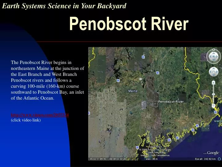
Earth Systems Science in Your Backyard. Penobscot River. clc. The Penobscot River begins in northeastern Maine at the junction of the East Branch and West Branch Penobscot rivers and follows a curving 100-mile (160-km) course southward to Penobscot Bay, an inlet of the Atlantic Ocean.

E N D
Earth Systems Science in Your Backyard Penobscot River clc • The Penobscot River begins in northeastern Maine at the junction of the East Branch and West Branch Penobscot rivers and follows a curving 100-mile (160-km) course southward to Penobscot Bay, an inlet of the Atlantic Ocean. • http://www.vimeo.com/2055324 • (click video link)
The River and its People The river is named after the Penobscot Nation who have lived on an island in the river for thousands of years. The river has been described as the lifeblood of the people. The river also has recreational and economic significance to the many towns along its shores.
The past 150 years In Eastern, Central, and Northern Maine, the Penobscot River has been used by many industries over the last two centuries. Each use of the river has had an impact on the health of the river and the types of life it can support. • Logging • Pulp and Paper Mills • HoltraChem mercury spills • Hydro dams • Clean Water Act • Restoration Project
Earth Systems Science As you learn about the impacts the river uses have had you should begin to notice that no impact stands alone. All the Earth systems are connected. For example, a chemical discharge into the river will impact the water (hydrosphere) and the fish (biosphere) which could harm the fisherman who catch and eat the fish (ecosphere).
Logging “Lumber Capital of the World“ The first sawmill in Bangor was built in 1772. By the mid 1830’s Bangor was home to more than 300 sawmills. By 1834, Bangor's was a boom town. In addition to the lumber industry, Penobscot River ice was harvested and shipped to ports on the Atlantic coast. By the end of the century the city began to lose its mills. Today, there are no mills in Bangor. But remnants of the logging can still be found in the riverbed and the industry had long-lasting impacts on the river ecology.
Pulp and Paper Mills The Bucksport paper mill, at the mouth of the Penobscot, cannot use the salty river water. Instead, a series of pumping stations and gravity feeds were built to connect three nearby lakes (Toddy Pond, Alamoosook Lake and Silver Lake) to provide millions of gallons of fresh water daily to the mill. This reduction in the lakes must be monitored as to not impact the ecology. Although the mill does not draw water from the river it does put discharge into the river. In the past dioxin was discharged in the river. Dioxin accumulates in the fatty tissue of the fish and is a known carcinogen in humans. • A comparison of chemical discharge found below an upstream mill and a mill at the river’s mouth would indicate the impact of the tides on the build-up of discharged chemicals. The tide is likely to cause the discharge to be diluted faster as it will rapidly enter into the deeper and faster-moving waters in Penobscot Bay.
Holtrachem Holtrachem, located along the river, had a hazardous spill in the river in the 1990’s. The level of mercury has negatively impacted the fish. Maine DEP is working with the U. S. Environmental Protection Agency and the current and former owners of the plant to clean up pollution at the site. Spills, mostly of process brine, in the manufacturing area have created mercury-contaminated ground water that is partially captured at a river-side extraction well. The collected groundwater from both areas is pumped to the wastewater treatment system where it is treated and after treatment, discharged to the Penobscot River. The portion of the plume that is not captured presumably discharges to the river. Mercuric chloride is believed to be the principal form of mercury that was discharged into the Penobscot River. Mercury in this form does not vaporize, but it is soluble and can be converted to methyl mercury. Methyl mercury accumulates and concentrates in fish tissues as small fish are eaten by larger ones. Humans consuming the fish can incur toxic effects include damage to the brain, kidney, and lungs.
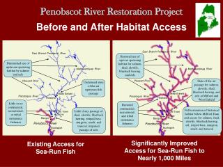
Hydropower Dams Historically, the Penobscot River held Maine's largest populations of Atlantic salmon with annual runs estimated at 50,000-70,000 adults prior to 1830. Dams, and log drives, have diminished fish populations by creating barriers, severe water pollution, and habitat degradation. While many of these problems have been addressed, multiple dams on the river continue to impede safe upstream and downstream passage for sea-run fish. The Penobscot River Restoration Project is working toward the successful restoration of Atlantic salmon and the ten other species of native sea-run fish in the Penobscot.
Clean Water Act During the mid 20th century, the community riverfronts in the region began a period of decay and industrial pollution greatly damaged the health of the river. Due to the Clean Water Act of 1972, there have been major improvements in the Penobscot River over the past 35 years. Today the water quality in the Penobscot River is greatly improved.
River Restoration Watch this video: http://www.youtube.com/watch?v=mUKWvlhKdFc The Penobscot River Restoration Project's reconfiguration of dams will have a wide range of benefits to fish and wildlife populations, water quality and communities along the river.By removing two dams the Penobscot River Restoration Project intends to “restore the Penobscot Indian Nation's ability to obtain sustenance and cultural identity from the river that bears their name. For over 100 years, the Penobscot Indian Nation has been deprived of the opportunity to exercise their tribal fishing rights because the river is virtually devoid of its native sea-run fisheries above Veazie Dam.” The PRRP goes beyond restoring migratory fish. The benefits extend to the whole ecosystem and the Gulf of Maine. Removal of the dams will restore natural functions of the lower river. Nutrients derived from sea-run fish will reach farther up river, and the natural flushing of sediments will reach Penobscot Bay, restoring a natural cycle to the river. For a more in-depth look at the PRRP, watch: http://www.youtube.com/watch?v=MX4FRWmriaw
Now that you’ve learned about the lower portion of the Penobscot,think about the history of the your local watershed. • Conduct research and natural history interviews to compile ideas on how your rivershed has changed over time. • Use this information to create a timeline. • Give examples of how the Earth systems are connected.
How does the river in YOUR backyard compare? Share your results! You can compare your findings with those found by others by submitting your work to the Challenger Learning Center of Maine where we will upload your work to a growing list at our website, www.clcofme.org.
Monitor Your Watershed Request a “Get Bugged card/key chain” developed by USEPA Office of Science and Technology (nscep@bps-lmit.com) It is a laminated card depicting macroinvertebrates (bugs) that can live only in healthy streams. It comes with a keychain magnifying glass that you can use to examine a water sample from your watershed.
Join others around the world in water monitoring. You can order a simple, easy to use water testing kit from www.worldwatermonitoringday.org If you monitor between July and October you can register your site, and post your data on-line as part of World Water Monitoring Day, the international education and outreach program that builds public awareness and involvement in protecting water resources around the world by engaging citizens to conduct basic monitoring of their local water bodies. 46,000 People in 43 Countries Monitored in 2007
Make a difference! Now that your know why rivers are important and how they can be restored find a way to help protect the river In Your Backyard! * Organize your own cleanup activity. * Organize a storm drain marking project . Storm drains carry runoff directly into streams, lakes and bays, and nothing should be dumped in them. Get information on labeling storm drains in your neighborhood, www.epa.gov/npdes/stormdrainmarking. To learn more about watersheds, Visit www.epa.gov/owow/watersheds