Download
1 / 31
310 likes | 416 Views
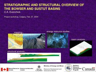
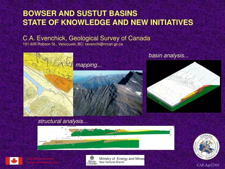
BOWSER AND SUSTUT BASINS STATE OF KNOWLEDGE AND NEW INITIATIVES C.A. Evenchick, Geological Survey of Canada 101-605 Robson St., Vancouver, BC; cevenchi@nrcan.gc.ca. basin analysis. mapping. structural analysis. Natural Resources Canada. Ressources Naturelles Canada.

E N D
BOWSER AND SUSTUT BASINS STATE OF KNOWLEDGE AND NEW INITIATIVES C.A. Evenchick, Geological Survey of Canada 101-605 Robson St., Vancouver, BC; cevenchi@nrcan.gc.ca basin analysis... mapping... structural analysis... Natural Resources Canada Ressources Naturelles Canada CAE Apr22/03
Bowser and Sustut Basins - state of knowledge and new initiatives OUTLINE • history of research, quality of coverage • regional geological framework and terminology • stratigraphic framework • structural framework • new initiatives… together with discussion of: Skeena Group (Haggart) Aeromagnetic … (Lowe) ….will put us in position to discuss: Thermal Maturation and petroleum systems (Osadetz) Coal Bed Methane (Ryan) CAE Apr22/03
REGIONAL GEOLOGICAL FRAMEWORK - location • north-central British Columbia • in Intermontane Belt of the Canadian Cordillera, a region of low metamorphic grade relative to the bounding Omineca Belt (metamorphic) and Coast Belt (plutonic and metamorphic • overlies Stikine Terrane (Stikinia), a terrane allochthonous to the North American margin prior to deposition of Bowser and Sustut basin strata • Stikinia and overlap basins are separated from certain North American rocks by oceanic Cache Creek terrane CAE Apr22/03
… a quick history of research 1962: parts of northern Bowser and Sustut basins recognized in 1956 GSC mapping; 2 wells drilled 1969, 1972 2003: regional mapping across most of basin area; some remains at reconnaissance level of knowledge. 7 graduate theses. 1944: Bowser and Sustut basins not known to exist, although exploration in the Groundhog Coalfield dates back to the early 1900’s CAE Apr22/03
REGIONAL GEOLOGICAL FRAMEWORK - central BC geology • basins are Jurassic and Cretaceous clastic rocks • overlie Triassic and lower Jurassic volcanic arc rocks (Stuhini, Hazelton groups) • deformed in Cretaceous to form Skeena Fold Belt that terminates on the NE in a frontal triangle zone within Sustut Basin strata • intruded on west by early Tertiary plutonic rocks (Coast Belt), and locally in southeast by Cretaceous and early Tertiary plutons • overlain by late Tertiary and Quaternary volcanic rocks (minor) CAE Apr22/03 modified from Evenchick and Thorkelson, GSC Bull. 577, 2003/in press
STRATIGRAPHIC FRAMEWORK Table of formations, Spatsizi River map area. Time scale of Harland et al. (1990). Stratigraphy of Spatsizi River area is typical of other regions in the vicinity of the Bowser and Sustut basins: MESOZOIC BASINS Cretaceous Sustut Basin; nonmarine Jurassic-Cretaceous Bowser basin; marine and nonmarine MESOZOIC ARCS Triassic and lower Jurassic volcanic arc rocks (plutons, volcanic rocks, related sedimentary rocks) STIKINE ASSEMBLAGE Paleozoic metavolcanic rocks, metaplutonic rocks, carbonates CAE Apr22/03 modified from Evenchick and Thorkelson, GSC Bull. 577, 2003/in press
STRATIGRAPHIC FRAMEWORK - BOWSER LAKE GROUP Lithofacies assemblages new stratigraphic approach to better deal with the Bowser Basin on regional scale and provide conceptual tools for interpreting basin architecture and depositional history (when integrated with regional fossil distribution) modified from Evenchick and Thorkelson, GSC Bull. 577, 2003/in press CAE Apr22/03
STRATIGRAPHIC FRAMEWORK - BOWSER LAKE GROUP Lithofacies assemblages integrating distribution of lithofacies assemblages with fossil data gives a general picture of depositional history of the basin on a regional scale modified from Evenchick and Thorkelson, GSC Bull. 577, 2003/in press modified from Evenchick etal., 2001, GSC Open File 3956 CAE Apr22/03
STRATIGRAPHIC FRAMEWORK - BOWSER LAKE GROUP Devils Claw Formation (alluvial, fluvial) Jenkins Creek assemblage (nonmarine) Groundhog-Gunanoot assemblage (deltaic) Skelhorne assemblage (deltaic) Eaglenest assemblage (deltaic) Muskaboo Creek assemblage (shelf) Todagin assemblage (slope) Ritchie-Alger assemblage (submarine fan) sandstone, siltstone, rare conglomerate; about equal proportions of sheet-like intervals up to 50 m thick dominated by either siltstone and very fine-grained sandstone, or by medium-grained sandstone; abundant turbidite features (e.g. Bouma cycles, flame structures, flute and groove casts); conglomerate is minor in most regions, and includes poorly sorted units considered to be debris flows; marine fossils CAE Apr22/03
STRATIGRAPHIC FRAMEWORK - BOWSER LAKE GROUP Devils Claw Formation (alluvial, fluvial) Jenkins Creek assemblage (nonmarine) Groundhog-Gunanoot assemblage (deltaic) Skelhorne assemblage (deltaic) Eaglenest assemblage (deltaic) Muskaboo Creek assemblage (shelf) Todagin assemblage (slope) Ritchie-Alger assemblage (submarine fan) siltstone, fine-grained sandstone, conglomerate; mainly laminated siltstone and fine grained sandstone which is dark grey to black weathering, and includes thin orange weathering claystone beds and syndepositional faults and folds; chert pebble conglomerate occurs as lenses; marine fossils present CAE Apr22/03
STRATIGRAPHIC FRAMEWORK - BOWSER LAKE GROUP Devils Claw Formation (alluvial, fluvial) Jenkins Creek assemblage (nonmarine) Groundhog-Gunanoot assemblage (deltaic) Skelhorne assemblage (deltaic) Eaglenest assemblage (deltaic) Muskaboo Creek assemblage (shelf) Todagin assemblage (slope) Ritchie-Alger assemblage (submarine fan) siltstone, fine-grained sandstone, conglomerate; mainly laminated siltstone and fine grained sandstone which is dark grey to black weathering, and includes thin orange weathering claystone beds and syndepositional faults and folds; chert pebble conglomerate occurs as lenses; marine fossils present CAE Apr22/03
STRATIGRAPHIC FRAMEWORK - BOWSER LAKE GROUP Devils Claw Formation (alluvial, fluvial) Jenkins Creek assemblage (nonmarine) Groundhog-Gunanoot assemblage (deltaic) Skelhorne assemblage (deltaic) Eaglenest assemblage (deltaic) Muskaboo Creek assemblage (shelf) Todagin assemblage (slope) Ritchie-Alger assemblage (submarine fan) sandstone, siltstone, conglomerate; primary lithofacies is sandstone forming laterally continuous thin- to thick-bedded sheets; less common are siltstone interbedded with sandstone, and lenses of conglomerate; sandstone is thin- to thick-bedded, locally arranged in coarsening-up cycles; includes burrows, bivalve coquina, and other marine fossils, common ripple marks and cross bedding, with local hummocky cross stratification; conglomerate increases in proportion and thickness upsection CAE Apr22/03
STRATIGRAPHIC FRAMEWORK - BOWSER LAKE GROUP Devils Claw Formation (alluvial, fluvial) Jenkins Creek assemblage (nonmarine) Groundhog-Gunanoot assemblage (deltaic) Skelhorne assemblage (deltaic) Eaglenest assemblage (deltaic) Muskaboo Creek assemblage (shelf) Todagin assemblage (slope) Ritchie-Alger assemblage (submarine fan) conglomerate, sandstone, siltstone, mudstone, and rare coal; arranged in coarsening- and fining-up cycles of mudstone to pebble or cobble conglomerate; prominently rusty weathering, and 30 to 80% conglomerate; sheets of conglomerate to 50 m thick include planar beds, tabular planar cross stratification and trough cross stratification, sets locally up to 10’s of metres thick; sandstone has planar cross stratification and hummocky cross stratification; sparse marine fossils but abundant plant fossils, including silicified log fragments CAE Apr22/03
STRATIGRAPHIC FRAMEWORK - BOWSER LAKE GROUP Devils Claw Formation (alluvial, fluvial) Jenkins Creek assemblage (nonmarine) Groundhog-Gunanoot assemblage (deltaic) Skelhorne assemblage (deltaic) Eaglenest assemblage (deltaic) Muskaboo Creek assemblage (shelf) Todagin assemblage (slope) Ritchie-Alger assemblage (submarine fan) thinly interlayered and vari-coloured siltstone, sandstone, and conglomerate (with or without coal), commonly arranged in coarsening- and thickening-upward cycles; common features of sandstone are parallel bedding, cross bedding, ripples, burrows, bivalve coquina; conglomerate comprises a lower proportion of the unit (15 to 30%) than in the Eaglenest assemblage; conglomerate units up to 50 m thick cap cycles up to 70 m thick, and tops locally have megaripples; plant and marine fossils are ubiquitous, trace fossils including Skolithus and Diplocraterion are common, as are log fragments several metres long CAE Apr22/03
STRATIGRAPHIC FRAMEWORK - BOWSER LAKE GROUP Devils Claw Formation (alluvial, fluvial) Jenkins Creek assemblage (nonmarine) Groundhog-Gunanoot assemblage (deltaic) Skelhorne assemblage (deltaic) Eaglenest assemblage (deltaic) Muskaboo Creek assemblage (shelf) Todagin assemblage (slope) Ritchie-Alger assemblage (submarine fan) sandstone, siltstone, carbonaceous and calcareous mudstone, with minor conglomerate and coal; locally arranged in fining-up cycles; sandstone is fine- to medium-grained with planar bedding and planar tabular cross bedding; most sandstone is thin- and thick-bedded, medium-grained, recessive weathering wacke; resistant weathering arenite is less common and forms discontinuous sheets and lenses; finer grained strata are thinly bedded and locally include densly packed plant fossils; conglomerate sheets and lenses, <10% of the unit, include large scale cross bedding; plant fossils are common and include in-situ trees; marine fossils are rare CAE Apr22/03
STRATIGRAPHIC FRAMEWORK - BOWSER LAKE GROUP Devils Claw Formation (alluvial, fluvial) Jenkins Creek assemblage (nonmarine) Groundhog-Gunanoot assemblage (deltaic) Skelhorne assemblage (deltaic) Eaglenest assemblage (deltaic) Muskaboo Creek assemblage (shelf) Todagin assemblage (slope) Ritchie-Alger assemblage (submarine fan) conglomerate, sandstone, siltstone; a high proportion of pebble conglomerate (30-80%) in laterally continuous sheets with large-scale cross bedding; conglomerate forms bases of fining-up cycles with medium-grained sandstone, fine-grained sandstone, carbonaceous siltstone, and minor coal; sandstone has platy and trough cross bedding; fossil plants common; marine fossils absent CAE Apr22/03
STRATIGRAPHIC FRAMEWORK - BOWSER LAKE GROUP Devils Claw Formation (alluvial, fluvial) Jenkins Creek assemblage (nonmarine) Groundhog-Gunanoot assemblage (deltaic) Skelhorne assemblage (deltaic) Eaglenest assemblage (deltaic) Muskaboo Creek assemblage (shelf) Todagin assemblage (slope) Ritchie-Alger assemblage (submarine fan) mudstone, siltstone, fine-grained sandstone, medium-grained sandstone, rare conglomerate and coal; commonly arranged in fining-up cycles; sandstone is grey, green, and brown weathering and occurs as laterally continuous sheets, discontinuous sheets, and lenses; lenses are planar and trough cross bedded; fossil plants abundant, including in-situ roots and plants with delicate structure; marine fossils absent CAE Apr22/03
STRATIGRAPHIC FRAMEWORK - BOWSER LAKE GROUP Bathonian/Callovian Early Oxfordian Lithofacies assemblage map of the northern 2/3 of the Bowser Basin Middle Oxfordian – Early Kimmeridgian Late Kimmeridgian – Earliest Cretaceous mid-Cretaceous CAE Apr22/03
STRATIGRAPHIC FRAMEWORK - SUSTUT GROUP More than 2000 m of nonmarine clastic strata, divided into two formations: Brothers Peak Formation Tango Creek Formation At least 700 m thick on the SW side of the basin. It overlies lower units in angular unconformity. A base of quartz pebble conglomerate or coarse fanglomerate is overlain by primarily sandstone, siltstone, and mudstone. Sandstone occurs as sheets and lenses of quartz- and chert-rich feldspathic arenite. Sandstone, siltstone, and mudstone form fining-upward cycles in the lower member. An upper member is mudstone, and calcareous siltstone and sandstone (Eisbacher, 1974). Detrital micas distinguish sandstone and siltstone from otherwise similar Bowser Lake Group. Age is Barremian or Early Albian to Late Campanian NE CAE Apr22/03
STRATIGRAPHIC FRAMEWORK - SUSTUT GROUP Brothers Peak Formation Tango Creek Formation Conformably overlies Tango Creek Fm. Characterized by polymict conglomerate, sandstone, and siliceous tuff. Commonly has a basal conglomeratic succession more than 50 m thick which includes siliceous ash-fall tuff. The conglomeratic base is overlain by a succession dominated by pebbly sandstone, siliceous ash-fall tuff, and mudstone, with rare coal. Sandstone occurs as sheets and as lenses (Eisbacher, 1974). Age is Late Campanian to late Early Maastrichtian. SE KBP KBP KBP KTC KTC KTC CAE Apr22/03
STRUCTURAL FRAMEWORK – THE SKEENA FOLD BELT REGIONAL RELATIONSHIPS Location of cross-section Strata of the 3 main clastic successions, and underlying Stikinia, are folded and thrust faulted. Contractional structures define the Skeena Fold Belt, a thin skinned fold and thrust belt of Cretaceous age. The dominant fold trend is northwest, but domains of northeast trending structures occur locally on the west side of the fold belt (Evenchick 1991a,b; 2001). modified from Evenchick, 2001 CAE Apr22/03
STRUCTURAL FRAMEWORK - SKEENA FOLD BELT FIRST ORDER FEATURES - GEOMETRY AND SCALE • dominant structures are folds; they are close to tight, and upright to inclined to the northeast; they have wavelengths of hundreds of metres to 1 km; larger wavelength folds are associated with structural culminations of competent volcanic rocks of Stikinia. NE Bowser Lake Group Bowser Lake Group NE SE NE Sustut Group Bowser Lake Group CAE Apr22/03
STRUCTURAL FRAMEWORK - SKEENA FOLD BELT FIRST ORDER FEATURES - GEOMETRY AND SCALE • dominant structures are folds; they are close to tight, and upright to inclined to the northeast; they have wavelengths of hundreds of metres to 1 km; larger wavelength folds are associated with structural culminations of competent volcanic rocks of Stikinia. NE from Evenchick and Thorkelson, GSC Bull. 577, 2003/in press CAE Apr22/03
STRUCTURAL FRAMEWORK - SKEENA FOLD BELT FIRST ORDER FEATURES - GEOMETRY AND SCALE • thrust faults are present but, unless cut-offs are recognized, they are difficult to recognize because Bowser Lake Group lacks distinctive regional stratigraphic markers NE CAE Apr22/03
STRUCTURAL FRAMEWORK - SKEENA FOLD BELT FIRST ORDER FEATURES - GEOMETRY AND SCALE • contractional structures affect underlying successions of Stikinia NE JHSu JHCu JHSu JHCu from Evenchick and Thorkelson, GSC Bull. 577, 2003/in press CAE Apr22/03
STRUCTURAL FRAMEWORK - SKEENA FOLD BELT FIRST ORDER FEATURES - MAGNITUDE OF SHORTENING • the fold belt accommodated a minimum of 44% horizontal shortening by folds and thrust faults • distinctive map units in the northeastern fold belt permit construction of balanced cross sections NE modified from Evenchick 1991 Tectonics vol 10 • in the Bowser Lake Group, excellent exposure • permits estimation of minimum shortening • by measuring bed-lengths of local markers NE from Evenchick and Thorkelson, GSC Bull. 577, 2003/in press CAE Apr22/03
STRUCTURAL FRAMEWORK - SKEENA FOLD BELT FIRST ORDER FEATURES - BOUNDARIES • the fold belt terminates to the northeast in a triangle zone within the Sustut Group • it is interpreted to root to the west in the Coast Belt, where there are contracrtional structures of similar age Triangle zone NE KTC KBP NE NE KBP KBP KTC KBP KTC CAE Apr22/03
STRUCTURAL FRAMEWORK - SKEENA FOLD BELT FIRST ORDER FEATURES - TIMING Relationships between structures and stratigraphic units indicate that orogenic shortening began prior to Albian time, and continued into the Maastrichtian or later. The youngest rocks deformed below the sub-Sustut angular unconformity are Oxfordian. The youngest deformed rocks in the fold belt are late Early Maastrichtian age (Brothers Peak Fm). KTC KBP The Sustut Group and Devils Claw Formation are inferred to be synorogenic clastic basin fill associated with formation of the Skeena Fold Belt (e.g. Evenchick, 2000); the Sustut Group formed in the foreland (basin) to the Skeena Fold Belt, whereas the Devils Claw formed in a piggy back basin within the fold belt. CAE Apr22/03
BOWSER/SUSTUT BASINS - NEW INITIATIVES Thermal mat. pre- 2002 Thermal maturation July 2002 • spring 2002: GSC began a joint project with the BC MEM New Ventures Branch to study the thermal history of the northern 2/3 of the Bowser and Sustut basins from GSC/BCMEM Open File 4343 • fall 2002 to present: project proposal to GSC to continue joint project with the BC MEM New Ventures Branch on energy resource potential of the Bowser and Sustut basins. Work to focus on energy resource studies and increased knowledge of the geological framework (stratigraphy, structure, basin architecture and history). Region extended to encompass entire basin area. Intended final product is Basin Atlas with unified, pan-basin terminology and interpretations. • Proposed length of project is 4 years. • “conditional” project approval granted by GSC early April ’03. CAE Apr22/03
BOWSER AND SUSTUT BASINS STATE OF KNOWLEDGE AND NEW INITIATIVES CONCLUSIONS • Recent work on the geological (stratigraphic/structural) framework vastly improves understanding of where to explore for particular types of plays by identifying and mapping lithofacies assemblages, and identifying primary structural characteristics of a regional fold and thrust belt, including the frontal triangle zone. • Although significant improvements have been made, there is much additional work required because large parts of the basin remain at reconnaissance level of knowledge. • The revised geologic framework reduces exploration risk, and will be used in future resource assessments. • The geologic framework serves as a base for beginning to understand the new thermal maturity model and exciting new petrographic and chemical work; the subjects of following presentations. CAE Apr22/03
Cited references and recent publications Eisbacher, G.H. (1974): Sedimentary history and tectonic evolution of the Sustut and Sifton basins, north-central British Columbia; Geological Survey of Canada, Paper 73-31, 57 p. Evenchick, C.A. (1991a): Geometry, evolution, and tectonic framework of the Skeena Fold Belt, north-central British Columbia; Tectonics, v. 10, p. 527-546. Evenchick, C.A. (1991b): Structural relationships of the Skeena fold belt west of the Bowser Basin, Northwest British Columbia. Canadian Journal of Earth Sciences 28, 973-983. Evenchick, C.A. (2000): Evolution of the Bowser Basin / Skeena Fold Belt: implications for tectonic models of the Rocky Mountain Fold and Thrust Belt and Omineca Belt; GeoCanada 2000 – the millenium geoscience summit, May 29-June 2, Calgary, Alberta. Evenchick, C.A. (2001): Northeast-trending folds in the western Skeena Fold Belt, northern Canadian Cordillera: a record of Early Cretaceous sinistral plate convergence; Journal of Structural Geology v. 23 p. 1123-1140. Evenchick, C.A., Poulton, T.P., Tipper, H.W., and Braidek, I. (2001): Fossils and facies of the northern two-thirds of the Bowser Basin, northern British Columbia; Geological Survey of Canada, Open File 3956. Evenchick, C.A., Hayes, M.C., Buddell, K.A., and Osadetz, K.G.(2002): Vitrinite reflectance data and preliminary organic maturity model for the northern two thirds of the Bowser and Sustut basins, north-central British Columbia. Geological Survey of Canada, Open File 4343 and B.C. Ministry of Energy and MInes, Petroleum Geology Open File 2002-1. Osadetz, K.G., Evenchick, C. A. , Ferri, F. , Stasiuk, L. D., and Wilson, N. S. F. (2003): Indications for effective petroleum systems in Bowser and Sustut basins, north-central British Columbia. in Geological fieldwork, 2002; B. C. Ministry of Energy and Mines, Paper 2003-1. Evenchick, C.A. and Thorkelson, D.J. (2003/in press): Geology of the Spatsizi River map area, north-central British Columbia, Geological Survey of Canada Bulletin 577. As of early April 2003 this publication is in editorial review by GSC editors; preliminary copies of the text will be provided by the author upon request. …….. Many more Bowser/Sustut/Skeena references are cited within these publications CAE Apr22/03