Download
1 / 45
450 likes | 579 Views
Geocaching using GPS Units & Mobile Devices. Presented by Carroll Ellis, M.S. MSiC Earth & Environmental Science Educator. Introduction. What is geocaching? Who are the geocachers? What are the rules and who enforces them? What are other parks doing?

E N D
Geocaching using GPS Units & Mobile Devices Presented by Carroll Ellis, M.S. MSiC Earth & Environmental Science Educator
Introduction • What is geocaching? • Who are the geocachers? • What are the rules and who enforces them? • What are other parks doing? • How can you prepare for geocaching?
What is geocaching? • Low-impact outdoor activity for GPS users of all ages • GPS = Global Positioning System
Global Positioning System • GPS is a system of 27 satellites (24 active, 3 reserve) to calculate your position. • Satellites transmit their current position down to Earth via radio waves.
GPS receiver • Receives signals from GPS satellites. • Determines latitude and longitude of your current position on the Earth's surface.
GPS receiver • Location can be displayed on a map background
GPS receiver • Display of distance, bearing and ETA to a selected waypoint
Other GPS receiver features • Determining satellite signal strength and margin of error • Marking waypoints (latitude and longitude coordinates) • Keeping a graphical track of your journey • Displaying street and topographical maps • Automatic route creation and traversal • Electronic compass • Barometric pressure altimeter
Uses for GPS receivers • Hiking and backpacking • Canoeing and marine navigation • Hunting and fishing • Bird watching • Search and rescue • Exercise progress tracking • Traveling via car, motorcycle, bicycle • Geocaching
Uses for GPS receivers GPS Data displayed in Google Earth from Bryant Park Field Study
Uses for GPS receivers GPS ART!- A Creative Medium
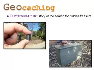
What is geocaching? • Outdoor adventure game for GPS users of all ages. • The basic idea is to set up caches (hidden containers) and share the locations (latitude/longitude) of these caches on the internet.
What is geocaching? • GPS users can then use the coordinates to find the caches. • The visitor may take something from the cache, leave something, and/or sign the logbook. • The “find” is then logged onto the Internet website where statistics about found and hidden caches are maintained.
What’s the point? • It may sound simple, but many caches are well hidden. • Many require searching and experience to find. • Only a few geocaches are accidentally found by non-geocachers.
What’s the point? • Sometimes just getting to the cache area can be a big part of the adventure. • It's one thing to see the latitude and longitude plotted on a map, but it can be quite a task to figure out how to get from here to there.
What’s the point? Geocaching can be thought of in two parts: • The journey to reach the cache area. • The challenge of actually finding the cache container. Both can be equally rewarding.
Misconceptions about geocaching • FACT: Geocaches are not allowed to be buried in the ground. “Geocaches are buried.”
Misconceptions about geocaching • FACT: Geocaches are not litter or abandoned property. “Geocaches are litter or abandoned property.”
Misconceptions about geocaching “Geocaching will damage the land.” • FACT: Geocaching foot traffic is similar to hiking, trail walking, or bird watching. • Most caches are placed near trails.
How Did It Get Started? • On May 1, 2000, the GPS signal degradation called Select Availability (SA) was removed. • The change allowed GPS units owned by civilians to be more accurate – to within 20 feet or better. • On May 3rd, 2000 someone hid a cache in Oregon and posted the coordinates on the Internet. It became the first geocache.
How Did It Get Started? • Jeremy Irish, the owner of the Geocaching.com website, expanded the idea and named it “Geocaching”. • Geocaching is now in all 50 states and more than 200 countries. • Geocaching.com is by far the #1 website for geocachers.
Geocache containers • A weather-resistant container such as Tupperware, Rubbermaid, or surplus ammo box
Geocache containers • Usually a weather-resistant container such as Tupperware, Rubbermaid, or surplus ammo box
What’s in a cache? • Logbook • Trinkets to trade • Examples: maps, books, software, hardware, CDs, videos, pictures, coins, tools, games, etc. • Information sheet that explains the container and geocaching, as well as contact information. • Disposable camera (optional)
What are the rules? Cache placement • No caches on land maintained by the U.S. National Park Service or U.S. Fish and Wildlife Service (National Wildlife Refuges) • No caches that are buried. • No caches placed on archaeological or historical sites. • No caches in Wisconsin SNAs
What are the rules? • No caches close to active railroad tracks. 150 feet minimum. • No caches on military installations. • No caches near or under highway bridges, dams, government buildings, or airports. • No caches on school property without permission.
What are the rules? Cache placement • No “vacation caches” • No cache closer than 0.1 mile (528 feet) to an existing cache. • Cacher owner must obtain permission from park manager, if required.
What are the rules? Cache contents • No food • No weapons (knives, ammunition, explosives) • No drugs or alcohol • No adult materials • No solicitations (business, religious, political)
Who enforces the rules? • Geocaching.com • Controls listing of geocaches worldwide on its website. • Caches are approved by volunteer reviewers. • Reviewers do not visit the geocache in person as part of the approval process. • Reviewers view the online description, coordinates, topo maps, proximity to other caches, compliance with known park rules.
Variations on the game • Traditional caches • Multi-caches / Offset caches • Virtual caches • Event caches • Travel bugs
Geocaching and Education Geocaching is a cross-curricular activity that educators, leaders and facilitators are incorporating into their programs with great success. Geocaching combines outdoor play with team-building, problem-solving and other valuable educational outcomes.
Geocaching and Education Geography Environmental Education Earth Science Health Mathematics
Geocaching and Education www.easygps.com


![Progressive Enhancement & Mobile [HOW Interactive 2012]](https://cdn4.slideserve.com/7565332/progressive-enhancement-mobile-dt.jpg)