Download
1 / 33
340 likes | 499 Views
Social Studies Middle East. Grade 4 For Educational Technology EDU 805 By Ghada Atallah. Contents. Prerequisite knowledge Lesson Plan ME Objectives Group work 1 Research Group work 2 Presentations Assessments Individual Work General Assessment. Prerequisite Knowledge.

E N D
Social StudiesMiddle East Grade 4 For Educational Technology EDU 805 By Ghada Atallah
Contents • Prerequisite knowledge • Lesson Plan ME • Objectives • Group work 1 • Research Group work 2 • Presentations • Assessments • Individual Work • General Assessment
Prerequisite Knowledge
How the globe is defined? Globe is defined by: Longitude Lines Equator Latitude Lines Prime Meridian
Four Cardinal Directions North West East South
Cardinal Points on the globe N W E S
What makes the world? 5 continents connected by water: Australia
What each continent consists of? Countries which are: • Defined by borders • Having a capital • Represented by a flag • Identified by a culture (civilization, language, music, art, etc.)
Lesson Plan Middle East (ME)
Objectives • To locate Lebanon geographically and its neighboring countries on the globe • To identify their geographical traits, climate, etc. • To study their demography, economy, religion, language, etc. • To identify similarities and differences of the Middle Easter countries
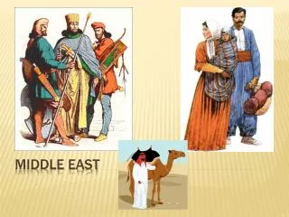
How the term “Middle East” was created? Middle East
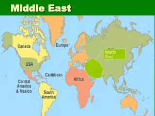
Definition of “Middle East” ? According to www.Merriam-Webster.com “Where Africa, Asia, and Europe Meet” Middle East Europe Asia Africa
ME Position on the globe Europe Asia Africa Equator
What country is the green? Europe Asia Africa Equator
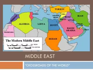
Countries of Middle East N Black Sea Caspian Sea Mediterranean Sea Lebanon W E Red Sea Arabian Sea S
Altitude & Longitude of ME 45.00 N N Black Sea Section 1 Caspian Sea Mediterranean Sea Lebanon W 30.00 N E Red Sea Arabian Sea 60.00 E 45.00 E 30.00 E Section 2 15.00 N S Equator
Middle East 45.00 N N Black Sea Section 1 Caspian Sea Turkey Mediterranean Sea Syria Lebanon Iraq Iran Palestine W Jordan 30.00 N E Red Sea Arabian Sea 60.00 E 45.00 E 30.00 E Section 2 15.00 N Arabian Sea S
Middle East Climate 45.00 N N Black Sea Caspian Sea Turkey Mediterranean Sea Syria Lebanon Iraq Iran Palestine Jordan W 30.00 N Kuwait E Bahrain Egypt Qatar Red Sea United Arab Emirates Arabian Sea Saudi Arabia 60.00 E 45.00 E 30.00 E Oman 15.00 N Yemen Arabian Sea S Equator
Section 1 N 45.00 N Turkey 30.00 E W Syria Iraq Iran E Lebanon Palestine Jordan 45.00 E 30.00 N S
Section 2 Kuwait 30.00 N Egypt 45.00 E Bahrain United Arab Emirates Qatar Oman Saoudi Arabia 30.00 E 15.00 N Yemen
Group Work 1 45.00 N N Mediterranean Sea Lebanon W 30.00 N E Red Sea Arabian Sea 60.00 E 45.00 E 30.00 E 15.00 N Yemen Arabian Sea S Equator
Area = 10,452 sq Km Climate: Mediterranean Highest Point = Qornat el Sauda Lowest point = Mediterranean sea 0 degrees, Religions: Christians, Muslims, Druze Languages: Arabic, French, English, Armenian Natural resources = Limestone, iron, ore, salt, water, arable land Environment = Deforestation, soil erosion, air pollution Geography = Nahr el Litani only river in the Near East not crossing international borders Agriculture: Citrus, grapes, tomatoes, apples, vegetables, potatoes, olives, tabbacco, sheep, goats Industries: Banking, tourism, food processing, wine, jewelery, cement, textile, mineral and chemicals products, wood and furniture products, etc. Exports Lebanon 7 groups of 3 students • Group 1 Demography/Flag • Group 2 Terrain/Vegetation • Group 3 Climate/Food/Dress • Group 4 Economy/Industry • Group 5 Natural Resources • Group 6 Capital/Cities and traits • Group 7 Environment/Water sources Beirut
Poster Area: 10,452 sqKm Capital: Beirut Climate: Mediterranean Highest Point = Qornatel Sauda Lowest point = Mediterranean sea 0 degrees, Religions: Christians, Muslims, Druze Languages: Arabic, French, English, Armenian Natural resources = Limestone, iron, ore, salt, water, arable land Environment = Deforestation, soil erosion, air pollution Geography = Nahr el Litani only river in the Near East not crossing international borders Agriculture: Citrus, grapes, tomatoes, apples, vegetables, potatoes, olives, tabbacco, sheep, goats Industries: Banking, tourism, food processing, wine, jewelery, cement, textile, mineral and chemicals products, wood and furniture products, Etc. Beirut
Group Work 2 Middle East (ME)
Group Work 2 Turkey Mediterranean Sea Syria Iraq Iran Jordan Egypt Red Sea Saudi Arabia Arabian Sea Equator
Group Assignments 1. Egypt 1 2 3 3. Syria 2. Turkey 4. Iraq 4 5 5. Iran 6 6. Jordan 7. Saudi 7
Presentations • All posters will be hanged according to their geographical relationship • Each member of the group will present part of the research • Discussion is led: compare and contrast the resources, climate, economy, etc.
Assessment of presentation Students will be assessed for: • The information • Depth of knowledge • Presentation of poster • Presentation skills
Individual Work
Assignment • Write a composition about what country do you like to visit from the ones that were presented in class and why? • The reasons should be supported by the findings.
General Assessment For the unit
General Assessments • Quizz: Multiple choice, matching, and fill in the blank • Presentations • Depth of understanding during the presentation and discussions • Composition