Download
1 / 14
150 likes | 237 Views
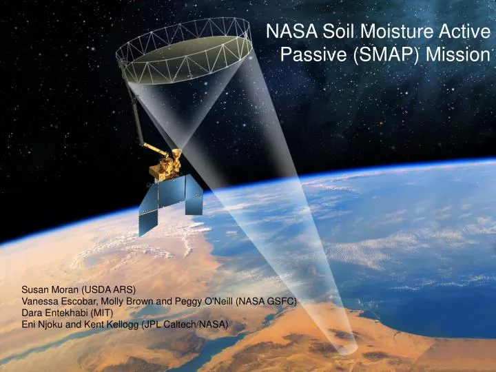
NASA Soil Moisture Active Passive (SMAP) Mission . Susan Moran (USDA ARS) Vanessa Escobar, Molly Brown and Peggy O'Neill (NASA GSFC) Dara Entekhabi (MIT) Eni Njoku and Kent Kellogg (JPL Caltech/NASA). Project/Mission Context. Feb 2008: NASA announces start of SMAP project

E N D
NASA Soil Moisture Active Passive (SMAP) Mission Susan Moran (USDA ARS) Vanessa Escobar, Molly Brown and Peggy O'Neill (NASA GSFC) Dara Entekhabi (MIT) Eni Njoku and Kent Kellogg (JPL Caltech/NASA)
Project/Mission Context Feb 2008: NASA announces start of SMAP project SMAP is a directed-mission with heritage from Hydros Hydros risk-reduction performed during Phase A (instrument, spacecraft dynamics, science, ground system) Cancelled 2005 due to NASA budgetary constraints US National Research Council Report: “Earth Science and Applications from Space: National Imperatives for the next Decade and Beyond”(National Research Council, 2007) http://www.nap.edu SMAP is one of four missions recommended by the NRC “Decadal Survey” for launch in the 2010–2013 time frame
Science Requirements (*) % classification accuracy (binary Freeze/Thaw) (**) [cm3 cm-3] volumetric water content, 1-sigma (1)North of 45N latitude
Soil Moisture Freeze/ Thaw Radiation Mission Science Objective Global mapping ofSoil Moisture and Freeze/Thaw state Primary Controls on Land Evaporation and Biosphere Primary Productivity
SMAP Mission Concept National Aeronautics and Space Administration Jet Propulsion Laboratory California Institute of Technology Pasadena, California • L-band unfocused SAR and radiometer system, offset-fed 6 m light-weight deployable mesh reflector. Shared feed for • 1.26 GHz dual-pol Radar at 1-3 km (30% nadir gap) • 1.4 GHz polarimetric Radiometer at 40 km • Conical scan, fixed incidence angle across swath • Contiguous 1000 km swath with 2-3 days revisit • Sun-synchronous 6am/6pm orbit (680 km) • Launch 2014 • Mission duration 3 years
Hydrometeorology Applications: NWP Trends in Short-Term Weather (0-14 Days) NWP Resolution SMAP Sources: Global Forecast/Analysis System Bulletins http://www.emc.ncep.noaa.gov/gmb/STATS/html/model_changes.html The ECMWF Forecasting System Since 1979 http://ecmwf.int/products/forecasts/guide/The_general_circulation_model.html
Climate Prediction Fischer et al. (2007): Soil Moisture–Atmosphere Interactions during the 2003 European Summer Heat Wave, Journal of Climate, 20, 5089-5099. 2003 European heat-wave caused 35,000 deaths New Scientist (Oct. 10 2003). Dry Spring Soil Moisture Wet Spring Soil Moisture Model simulations showing predicted summer air temperature anomalies using two different initializations of spring soil moisture conditions. Summer Air Temperature Anomaly [ºC] SMAP soil moisture observations would enhance quality of seasonal climate predictions.
Current NWS Operational Flash Flood Guidance (FFG) Flood Prediction and Drought Monitoring Current Operational Drought Indices by NOAA (NIDIS - National Integrated Drought Information System) Current: Empirical Soil Moisture Indices Based on Rainfall and Air Temperature ( By Counties >40 km and Climate Divisions >55 km ) Future: SMAP Soil Moisture Observations at 10 km
Applications of Seasonal Prediction and Human Health European heatwave cause 35,000 deaths, New Scientist, Oct. 2003. Seasonal Climate Prediction: 50 km Resolution Initialize rootzone moisture Fischer et al. (2007), J. of Climate, 20.
Climate Change and Water Resources Impacts Intergovernmental Panel on Climate Change (IPCC) climate projections : Change in Temperature [ºC] Change in Soil Moisture [%] 6 3 5 Models disagree on whether there would be MORE or LESS water compared to today 4 2 Models agree on basic temperature response 3 2 1 1 0 0 -1 -2 -1 -3 -4 -2 -5 -3 -6 Sahel Sahel SE Asia SE Asia S Europe S Europe Australia Australia N America N America Li et al., (2007): Evaluation of IPCC AR4 soil moisture simulations for the second half of the twentieth century, Journal of Geophysical Research, 112.
Carbon Dioxide Exchange Early Thaw Date (1998) Accumulated Carbon (g/m2) Normal to Late Thaw Dates (1995, 1996, 1997) The ‘missing carbon’: Depending on freeze/thaw date, same location can be a net source or net sink of carbon. SMAP freeze/thaw measurements would reduce errors in the closing of carbon budget. Goulden et al., 1998: Sensitivity of Boreal Forest Carbon Balance to Soil Thaw, Science, 279. Herring, D. and R. Kannenberg: The mystery of the missing carbon, NASA Earth Observatory.
Air Force Weather Agency will use experiment data to Initialize Numerical Weather Prediction (NWP) model for aviation weather, severe weather, cloud, and fog forecasts Input into Dust Transport Model (DTM) DoD Applications • US Army Space and Missile Defense Command, Army • Research Laboratory, G-2, Corps of Engineers, and • Marine Corps will use SMAP experiment data to validate • and improve tools to evaluate threat and friendly mobility • 1. Cross Country Mobility (CCM) • 2. Tri-service Integrated Weather Effects Decision Aid (IWEDA) • 3. Battlespace Terrain Reasoning / Awareness (BTRA) • 4. Opportune Landing System (OLS) • 5. Integrated air/space operations support models/analysis • 6. Civil-Military Operations (Agriculture Forecasts, • Water Resources Assessments) Naval Ice Center will use experiment data for high resolution mapping of marine and littoral ice cover and ice characteristics • Documentation • 1. AFSPC weather information key EDR • 2. JROC-Approved NPOESS IORD-II (KPP 4.1.6.1.6) SMDC-0902
National Aeronautics and Space Administration Jet Propulsion Laboratory California Institute of Technology Pasadena, California SMAP Data Products
Anthropogenic Radio-Frequency Interference (RFI) National Aeronautics and Space Administration Jet Propulsion Laboratory California Institute of Technology Pasadena, California RFI is evident and wide-spread (Data from SMOS) SMAP is taking aggressive measures to detect and mitigate RFI in its instrument and data processing designs.