Download
1 / 42
420 likes | 526 Views
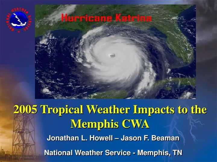
Jonathan L. Howell – Jason F. Beaman National Weather Service - Memphis, TN. 2005 Tropical Weather Impacts to the Memphis CWA. Memphis Tropical Impacts. Overview of Impacts From Hurricanes Katrina & Rita Satellite, Radar, & Track Overviews

E N D
Jonathan L. Howell – Jason F. Beaman National Weather Service - Memphis, TN 2005 Tropical Weather Impacts to the Memphis CWA
Memphis Tropical Impacts • Overview of Impacts From Hurricanes Katrina & Rita • Satellite, Radar, & Track Overviews • Synoptic Weather Patterns Responsible for Steering of Tropical Systems • Mesoscale Weather Environments • Katrina – Pressure Gradient Winds • Rita – Convective/Severe Weather Environment • Impacts to Memphis County Warning Area • WFO Operations Performance
Katrina Weather Impacts • Weather Impacts to North Mississippi • 7 Hours of Tropical Storm Force Wind Gusts (22z-06z) at Tupelo, MS ASOS (KTUP) • Maximum Gust – 46 Kts. – KTUP – 2350z/0148z • Unofficial Wind Gust Reports > 50 Kts. • Lowest Pressure – 980 mb. – KTUP – 07z • Rainfall Amounts Ranged Between 4”-8” Isolated Higher • Rain Gauge Measurements of 3”-6” Underestimated Actual Totals Due to High Winds
Katrina Damage Across Memphis CWA • Damage Across North Mississippi • Structural Damage – Mainly Trees Falling on Structures • Hundreds of Trees Downed/Uprooted • Powerlines Downed – 100,000+ Customers Without Power • Flash Flooding/Minor River Flooding • Water Over Secondary Highways • 5 River Points to Flood • Buttahatchie / Tombigbee / Noxubee / Town Cr.
Katrina Weather Impacts • Weather Impacts to West Tennessee • Tropical Storm Force Wind Gusts at Memphis (KMEM) & Jackson (KMKL) • 6 Hours at KMEM (03z-09z) • 3 Hours at KMKL (05z-08z) • Maximum Gust • 47 Kts. – KMEM – 0641z • 38 Kts. – KMKL – 0538z • Unofficial Wind Gust Reports > 50 Kts. • Lowest Pressures Recorded • KMEM – 989 mb. (0653z) • KMKL – 987 mb. (0953z) • Rainfall Amounts Ranged Between 3-6 Inches
Katrina Damage Across Memphis CWA • Damage Across West Tennessee • Minor Structural Damage • Several Trees Downed/Uprooted • Powerlines Downed – 77,000 Customers Without Power in Memphis/Shelby County • Additional Power Outages Across Remainder West TN • Flash Flooding/River Flooding • Water Over Secondary Highways • 1 River Point to Flood • S.F. Forked Deer
The Difference Aspects of Rita • There were three significant meteorological impacts to the Mid-South • Heavy Rain • Tropical Storm Force Wind Gusts • Severe Weather/Mesocyclone Development
Tropical Storm Force Wind Gusts • Numerous tropical storm wind gusts • KMEM 38 kts @ 1309Z • KTUP 48 kts @ 1725Z • Other unofficial reports of 35 to 45 kt winds primarily over north Mississippi • Gusts produced by convective downdrafts (50-55 dbz cores up to 10,000 feet)
Concerns as Rita Approached the Mid-South • Although Rita was a depression as it approached the Memphis CWA, it moved at a very favorable heading for producing tornadoes (010-040 degrees). (Malkin and Schulz, Jr., 1966) • Forecasters at WFO Memphis were tracking many mesocyclones across Arkansas and central Mississippi. Would conditions be right for tornadoes to occur in the Memphis CWA? • With this in mind, we’ll take a look at the mesoscale environment as Rita progressed into the Mid-South • The focus will be on the morning of September 25th.
Rita Damage • Light to moderate damage across E AR, W TN, and N MS • Damage confined to downed trees and power lines (mainly in N MS) • 3 to 6 inches of rain caused road and isolated residential flooding • Total damage estimated at $100K +
Summary • Katrina damage primarily from gradient winds • Tropical storm wind gusts occurred well west of center • Total Katrina damages in hundreds of thousands • Damages to structures, trees, & power lines
Summary • Rita damage primarily from convective wind gusts • Tropical storm force wind gusts occurred primarily in bowing line segments & mesocyclones • Total Rita damages > $100K • Damage mainly to trees and power lines