Download

1 / 64
660 likes | 907 Views
AL Map Reading Exercise. What are the major elements of a map?. Scale Conventional signs Grid reference Title. 10 cm. 5 cm. Scale. Scale 1:20,000 1cm = 20,000cm = 200m = 0.2km 1:20,000. 14. 12. 13. 29. 28. 27. Grid reference. Grid square 1328. Grid reference 134276 .

E N D
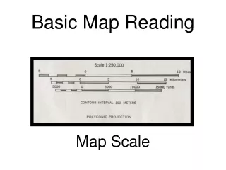
What are the major elements of a map? • Scale • Conventional signs • Grid reference • Title
10 cm 5 cm Scale • Scale 1:20,000 • 1cm = 20,000cm = 200m = 0.2km • 1:20,000
14 12 13 29 28 27 Grid reference Grid square 1328 Grid reference 134276
What does a map tell us? • location • land use • relief • communication • drainage • vegetation
Main road Secondary road Main road Main road Secondary road 934830 934860 Transect Rural residential Farmland Woodland Vacant land Recreational Squatter Farmland Public housing
Main road Secondary road Main road Main road Secondary road 934830 934860 Transect Rural residential Farmland Woodland Vacant land Recreational Squatter Farmland Public housing
Favourable factors for farming • fertile alluvial soil along lower course of river • adequate fresh water supply from dense network of streams • flat and gentle relief as indicated by winding/ meandering river channels and absence of closely spaced contours
Yuen Long as market town and collection / distribution centre well-developed road networks / highways facilitate transport of farm products • electricity supply as indicated by presence of power line
Major changes in land use • filling up of fish ponds • for industrial land use (Yuen Long Industrial Estate) • And residential land use (Tin Shui Wai) • As part of the development of Yuen Long new town • increase in transportation land use
Yuen Long Highway and light rail transit • to improve accessibility of Yuen Long new town • increase in recreational land use • Tin Shui Wai Park and Yuen Long Park • for rising population
Impact of urbanization • farmland becomes fragmented by the construction of road networks • farmland formerly at outskirt of town substituted by urban land uses • former land left vacant or used as open storage of container
depots at outskirt of town and along major transport / extensification • routeways while waiting for urban development I speculation • fish ponds at Tin Shui Wai totally taken up for urban development • intensification I market gardening
Reasons of Flooding • concentration of heavy rainfall in summer from June to August extensive flat and low land serves as the flood plain as indicated by the presence of winding / meandering river channels impermeable bedrock layer indicated by the presence of fish ponds inhibits draining of flood water • urban development increases water-proof land surface which • helps to retain flood water
Damages of Flooding • inundation of fields ruins crops • (sample grid square: 9484 / 9584) • - disruption of road transport • (sample grid square : 9285 / 9286) • - inundation of villages as they are closed to farmland in low-lying areas (sample grid square: 9285/9384 /9485 /9585)
Human Effort road embankments e.g. Yuen Long Highway to minimize impact from flood effectiveness depends on scale of floods effectiveness depends on scale of floods and silt content of flood water straightened river channels (e.g. Shan Pui River) to drain flood water in a faster rate dredging of channels has to be done during low water seasons to maintain flow
1995 Scale Key
People modified the channel • straightening the river channel • constant width
Reasons for such modifications • increase velocity of the river • i.e. improved efficiency of the channel slope, reduce friction, therefore increase velocity and transport capacity • less deposition • avoid silting • prevent flooding • less pollutants accumulate in the river
Reasons of Flooding • heavy rainfall with long duration / prolonged rain storm • low-lying relief • changing type of land use / illegal change of land use • increase in abandoned land • old car dumping and open storage • increase soil erosion
Reasons of Flooding • increase loads in the river • silting of river • more construction work i.e. compaction and development of concrete surface • lower infiltration • more surface runoff
1991 on level land below 20 metres on slopes of foothills up to 50 metres require extensive flat land, alluvial soils, ample water supply for irrigation require well-drained soils on foothills
Impact of Ferry Pier(economic) • improve accessibility to urban area, • facilitates marketing of agricultural products, • better income from non-rural employment (part-time farmers), • services provided to visitors from urban area generate employment and earnings
Impact of Ferry Pier (environmental) • Traffic volume increases, • higher risk for coastal water to be polluted, danger of air and noise pollution, • influx of urban visitors, • scenic beauty of countryside disrupted
Village House Tai Tei Tong (B2) Pak Ngan Heung (B1) Tsoi Yuen Tsuen (A1) Luk Tei Tong (B3) Occupied (%) 88 84 90 65 Unoccupied (%) 12 11 6 15 Ruined (%) 0 5 4 20 Sub-total (%) 100 100 100 100 Total number 70 44 59 25
Ruined and occupied houses in Luk Tei Tong • Emigration/rural depopulation/rural-urban migration, • small village, • poor accessibility, • lack of services • (e.g. no schools, clinics)
Changes to rural housing • increasing proportion of ruined houses and unoccupied houses, • resettlement in public housing estates, • derelict houses in remote sites abandoned, • better housing due to increased income
1992 center of higher order services more higher order services e.g. fire station, police station center of lower order services services less than Yau Uk Tusen’s
sited near to main road located at a nodal point / more accessible larger catchment area / serving a greater number of population / a larger marketthreshold connected by road of single width less accessible less people come to here smaller market threshold / catchment area
null-hypothesis statement • There is no significant relationship between the gradient / slope angle and the density of vegetation growth
Findings • The more exposed the slope, the less the vegetation • Vegetation is less on spurs / hill-tops • Vegetation is denser in valleys • Areas(valleys) are sheltered / less disturbed • Environmental change in valleys being more gradual, etc. therefore better growth
(c Agricultural Research Station : for plant crop (with grid reference) Inland site / slope / contour as evidence Fishery Research Station : for fish crop ( with grid reference) Water body / level land as evidence
Sampling reduce difficulties and danger Time saving
example of human impacts irrigation – for cropping water drained / stored – for settlement / domestic use catchwater – for reservoirs
Evidence of Different Zone on the city margin / at the foothill/ small and irregular buildings layout high building density / rectangular blocks/large lower building density / more open space temporary housing Larger blocks, usually on reclaimed land
Sampling procedure • stratified sampling • select same number or proportional number of sample points from each land-use zone • random / systematic sampling • within the land-use zones, sample points are to be located either through systematic or random sampling
Advantage & Disadvantage • sampling points are selected objectively without any bias • Samples of different types of land use are included • the selected sample point may be inaccessible
Redevelopment opportunity • the urban airport • major source of noise pollution in urban Kowloon • A new airport is built in the suburban area • military land use (barrack) • occupy very accessible locations • symbolic value of military land uses in the inner city is diminishing
Redevelopment opportunity • the old public housing estates • They were built long time ago • The design and infrastructure arc outdated. • older residential districts • decaying areas • vacant land
Squatters are not included • the redevelopment opportunity of an area is determined by the value of land after redevelopment • and the existence of institutional barriers
Changes on farmland • the farmlands at the east and south of the typhoon shelter area abandoned, • secondary growth are seen on the sites • this is also true of the fields north of Lantau link e.g. Tai Lung , Lau Fa Tsuen • the farmlands extending from Tung Wan Beach towards Tin Liu disappear under reclamation, the land is barren
Adverse Effects of Construction • transport at the north, e.g. the link between Tin Hau Temple and Ma Wan Town is disrupted, causing inconvenience • air and sound pollution may affect the inhabitants e.g. Tin Liu villagers • as drainage pattern is altered, and soil is unprotected, bays in the east, e.g. Tung Wan, may be heavily polluted