Download

1 / 46
540 likes | 760 Views
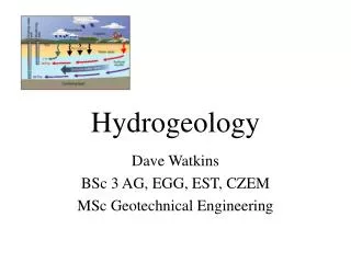
Contaminant Hydrogeology VII. Гидрогеология Загрязнений и их Транспорт в Окружающей Среде. Yoram Eckstein, Ph.D. Fulbright Professor 2013/2014. Tomsk Polytechnic University Tomsk, Russian Federation Fall Semester 2013. Subsurface Environment.

E N D
Contaminant Hydrogeology VII Гидрогеология Загрязнений и их Транспорт в Окружающей Среде Yoram Eckstein, Ph.D. Fulbright Professor 2013/2014 Tomsk Polytechnic University Tomsk, Russian Federation Fall Semester 2013
A Hidden Reserve: Groundwater Central-pivot irrigation utilizing groundwater, Jordan • Much of the global water, resides below the surface of the Earth as groundwater. • Although in the subsurface, it has a large impact on society and the features that we see on the surface of the Earth. • In general, surface water gets into the subsurface by infiltration. The Winter Park, Florida sinkhole
The Underground Reservoir • Some precipitation enters the subsurface via infiltration. • Soil properties and vegetation govern infiltration rate. • Infiltrated water adds to soil moisture and groundwater. • Soil moisture wets the soil. • Some is wicked up by roots, some is evaporated.
The Underground Reservoir • Some infiltrated water percolates to a deeper level. • It is added to water that fills subsurface void spaces. • This is groundwater.
Primary vs. Secondary Porosity • Primary Porosity – This is the porosity of the rock after it first lithifies/forms based on the spaces between grains. • Fine grained sediment has a lower porosity because the little grains can fill in the spaces. • Crystalline rocks have very low primary porosity. • Secondary Porosity – New pore space created in the rock at some time after the rock formed • E.g. Joints, Faults, Dissolution. • Because of secondary porosity any rock could potentially have some porosity.
Porosity vs. Permeability • If solid rock completely surrounds a water-filled pore, then the water cannot flow. • For groundwater to flow, pore spaces must be interconnected. • The ability of a rock to allow a fluid to flow through an interconnected network of pores is called Permeability. • If a rock has a high porosity, it does not necessarily have a high permeability. The pores must have interconnected conduits! • E.g. porous cork, is nearly impermeable • Permeability depends on: • Number of available conduits • Size of conduits • Straightness of conduits
Aquifers and Aquitards • Hydrogeologists distinguish between rocks that transmit water easily and rocks that do not easily transmit water. • Aquifer – A rock that easily transmits water • Aquitard – A rock that does not transmit water easily (i.e. retards water motion) • Aquifuge – A rock that does not transmit water at all • Unconfined Aquifer – An aquifer that has direct access to the surface of the Earth • Can be quickly recharged by meteoric water • Confined Aquifer – An aquifer that is trapped below an aquitardor aquifuge
Hydrogeologic Zones • Unsaturated Zone / Vadose Zone – The portion of the subsurface where some of the pores are filled with only air. • Saturated Zone / Phreatic Zone – The portion of the subsurface where the pores are completely filled with water. • Water Table – The boundary between these two zones How deep does the saturated zone go? Hydrogeologists are not sure… At some depth (10-20km) water is utilized for metamorphic reactions.
Topography of the Water Table • The water table is not a flat surface that never changes… • It may have seasonal oscillations (wet dry seasons) and rise and fall • Underneath mountains and hills, the water table follows a similar but subdued shape
Perched Water Tables • A locally present aquitard may create a Perched Water Table, a localized phreatic zone (saturated) above the regional water table. Can form springs if the perched water table intersects surface topography
Recharge and Discharge • Groundwater flows downward in areas of Recharge, and upward in areas of Discharge. • But what causes groundwater to flow?? • Hydraulic Head: A measure of the potential energy available to drive the flow of a given volume of groundwater. • Groundwater flows from locations of high hydraulic head to low hydraulic head.
Hydraulic Head and Hydraulic Gradients • In an unconfined aquifer: • Hydraulic head = the weight of the water above it. (Similar to air pressure) • Water will always flow from regions of high to low head • In a confined aquifer: • Hydraulic head is measured by drilling holes into the ground and measuring the level to which water fills the hole. • Hydraulic Gradient: the change in head from one location to another. Controls groundwater velocity
Groundwater Discharge and Darcy’s Law • Groundwater discharge: • Henry Darcy (French Engineer), coined what we now call Darcy’s Law. • If you know: • the hydraulic gradient (Δh/j) • the hydraulic conductivity (K) • the area through which the water is flowing (A) • Discharge = Q = K(Δh/j)A • Sometimes we simplify this and say that • Discharge = Slope of Water Table × Permeability
How Fast Does Groundwater Flow? • Water in an ocean current ~ 3 km/hr (1.8 Mph) • Water in a river - up to 30 km/hr (18 Mph) • Groundwater – 0.01 - 1.4 m/day (~4-500 m/yr) • Why so slow? - Conduits are very curved and small, so groudwater must flow in a very crooked path and friction with conduit walls slows it down. • Hydrogeologists measure flow in some regions by injecting tracers (a dye, radioactive element, or bacteria) and monitor its movement. • Some groundwater may emerge after months or years, but some may not emerge for thousands to tens of thousands of years.
Wells – How We Get To Groundwater • Since water is important to society, access to groundwater is important. • We access groundwater through wellsand springs (where groundwater percolates out at the surface of the Earth). • An ordinary well penetrates to a depth below the water table where an aquifer allows access to flowing water. We then either pump it out (right) or manually pull up the water (below).
Well Drawdown & Cones of Depression • If a well pumps out water faster than it is replaced by normal groundwater flow, it draws down the water table in what is called a Cone of Depression. • Cones of depression can make nearby wells temporarily dry. • So when drilling a well, drillers must consider both the flow rate in the aquifer and the pumping rates of nearby wells.
Artesian Wells • In some places, groundwater does not need to be pumped out of a well; if water freely flows out of the well it is called a flowing artesian well. • To see why this happens, lets look at a city water supply and water towers. • Cities first pump water from the local aquifer/source into a high reservoir tank. • This high tank is connected to the houses in town by a network of underground pipes. • The pressure in the elevated tank provides the push to make water rise out of the pipes of town. The level to which the water will rise is called the Potentiometric Surface. • Therefore, the water company doesn’t have to pump water to your house, just to the raised tower. • So if you are on city water, you are likely getting it because you have an artesian connection to the city water.
Artesian Wells in Nature • An artesian well can occur in nature when a well penetrates a confined aquifer that is under great pressure. • If the potentiometric surface is above ground, the well will be a flowing artesian well. • If the potentiometric surface is above the water table, but below the ground, it will be a non-flowing artesian well.
Springs – What Conditions Cause Them to Form? • Spring – A location where groundwater is discharged from the ground • The springs can formin various hydrologic scenarios
Springs – What Conditions Cause Them to Form? • Note that an Artesian Spring is a natural feature while and artesian well is drilled by man.
Oasis...Mirage or Geology? • Folded aquifers and faults can cause an Oasis to form. • These are important stops for people traveling across the Sahara. • Faults can bring deep water up to the surface of the Earth forming a hot spring.
Karst Landscapes and Groundwater • Groundwater can dissolve calcite bearing rocks such as limestone. • When CO2 mixes with water is makes a weak acid called carbonic acid that speeds this process. • Over time, changes in the water table may form complex networks of caves. • If a large cave becomes near to the surface of the Earth (usually by erosion), it can collapse forming a sinkhole. • Terrain dominated by sinkholes is called Karst Landscape or Karst Topography.
How Does Groundwater Flow Through Limestone? • Although limestone is nearly impermeable, it is commonly jointed. • The joints provide a secondary porosity and allow groundwater to flow through.
Karst Landscapes http://www.youtube.com/watch?v=YH5j_okckkY http://www.youtube.com/watch?v=n0op-h7yT2s&feature=fvwrel Arecibo Observatory, Puerto Rico
Groundwater…Infinite or Finite? • Although on scales of tens of thousands of years, groundwater is renewable, if usage is high, it can be a big problem on scales of years to hundreds of years. An Industrial well, lowers the water table and dries up a river
Groundwater Problems • Large wells can change the direction of groundwater flow moving contaminants into unsafe places.
Groundwater Problems • Saltwater is more dense than freshwater so it stays below the fresh water table. • Pumping and drawdown can cause saltwater influx into what would naturally be freshwater aquifers.
Groundwater Problems • Saltwater influx is a huge problem in Florida.
Groundwater Problems • Groundwater pressure holds grains of rock apart. • When water is removed, the once wet layer may become compacted, causing subsidence above the aquifer.
Methods for classification of groundwater contamination sources
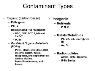
Potential sources of groundwater contamination by character of discharge • CATEGORY I: sources designed to discharge substances • Subsurface percolation (septic tanks, cesspools) • Injection wells • Hazardous waste • Non-hazardous waste (brine disposal, drainage) • Artificial recharge • Solution mining • Enhanced recovery • Land applications • Waste water (e.g., spray irrigation) • Waste water by-products (e.g., sludge) • Hazardous waste and non-hazardous waste (brine)
Potential sources of groundwater contamination by character of discharge • CATEGORY II: sources designed to store, treat, and/or dispose substances • Landfills • Industrial hazardous waste • Industrial non-hazardous waste • Municipal sanitary landfills • Surface impoundments • Hazardous liquid waste • Non-hazardous liquid waste (e.g., brine, sludge) • Mining waste tailings • Material stockpiles (coal, salt, etc.) • Illegal dumps
Potential sources of groundwater contamination by character of discharge • CATEGORY II: sources designed to store, treat, and/or dispose substances (continued) • Radioactive disposal sites • Low-level radioactive disposal sites • High-level radioactive disposal sites • Low-level & long half-lives radioactive materials • Above-ground storage tanks • Under-ground storage tanks • Mobile containers • Material stockpiles (coal, salt, etc.) • Illegal dumps • Graveyards
Potential sources of groundwater contamination by character of discharge • CATEGORY III: sources designed to retain substances during transport or transmission; discharge by accident or negligence • Pipelines • Overland transport
Potential sources of groundwater contamination by character of discharge • CATEGORY IV: sources discharging substances as a consequence of other planned activities • Irrigation practices (e.g., return flow) • Fertilizer application • Pesticide/herbicide application • De-icing salt application • Animal feeding operations (feedlots) • Urban runoff • Percolation of atmospheric contaminants • Mining effluents
Potential sources of groundwater contamination by character of discharge • CATEGORY V: sources providing conduit or inducing discharge through altered flow patterns • Production wells • Water wells • Oil/gas wells • Geothermal and heat recovery wells • Construction excavations
Potential sources of groundwater contamination by character of discharge • CATEGORY VI: naturally occurring sources; discharge created or exacerbated by human activity • Groundwater-Surface water interaction • Natural leaching • Saltwater intrusion • Salt- or brackish-water upconing
World Health Organisation (WHO) Drinking Water Quality Guidance 2011 Editors: WHO Number of pages: 564 Languages: English ISBN: 978 92 4 154815 1 http://www.who.int/water_sanitation_health/publications/2011/dwq_guidelines/en/index.html
Selected leachate components in municipal waste disposal sites (Source: U.S. EPA, 1977)