Download
1 / 12
120 likes | 128 Views
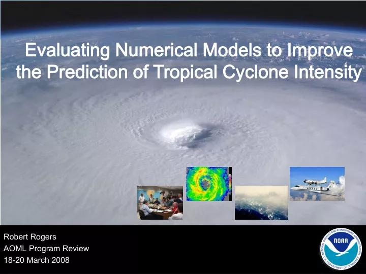
Evaluating Numerical Models to Improve the Prediction of Tropical Cyclone Intensity. Robert Rogers AOML Program Review 18-20 March 2008. Outline. Background and motivation Examples Surface winds Boundary layer structure Humidity Microphysics Rainfall. Background and motivation.

E N D
Evaluating Numerical Models to Improve the Prediction of Tropical Cyclone Intensity Robert Rogers AOML Program Review 18-20 March 2008
Outline • Background and motivation • Examples • Surface winds • Boundary layer structure • Humidity • Microphysics • Rainfall AOML Program Review
Background and motivation Improvements in intensity forecasts have lagged improvements in track forecasts Numerical model guidance can be key contributor to intensity forecasts Limitations in numerical models a significant contributor to slower improvements in intensity forecasts • inadequate specification of the TC vortex in the initial conditions • deficient representation of physical processes • insufficient resolution AOML Program Review
Background and motivation Comparing numerical models with observations in a robust manner can identify deficiencies in the models and lead to improvements in those models HRD is uniquely positioned to contribute to this effort through a combination of data collection and analysis and numerical model experiments AOML Program Review
Surface wind structure H*Wind GFDL 30-h forecast How well do numerical models predict magnitude and distribution of surface wind field? Errors in forecasts of radial location (nm) of 34-kt wind radii for landfalling TCs 34-kt Peak wind 142 kt 64 kt 50 kt Peak wind 105 kt • Comparisons between models and observations • peak wind weaker • RMW larger, 34- and 64-kt isotachs at larger radii • wind field more symmetric 64 kt 50 kt • Possible deficiencies • initial vortex too large, symmetric • resolution too coarse Surface winds (kt) for Hurricane Ivan valid 18 UTC Sept. 11 AOML Program Review
Boundary layer structure How well do numerical models depict the mean and turbulence structure of the tropical cyclone boundary layer? theta profiles sensible heat flux profiles Observed profiles from CBLAST dropsondes Observed profiles from CBLAST turbulence probe and fast-response T probe • Comparisons between models and observations • uncoupled model boundary layer is too warm; coupling improves profile • uncoupled heat flux is in wrong direction • Possible deficiencies • heat and moisture transfer coefficients specified incorrectly • sea-spray effects not represented adequately
Humidity G-IV flight track 10-15% RH Drier 5-10% RH Moister 10-25% RH Drier 10-15% RH Moister How well do numerical models represent initial humidity fields? • Comparisons between models and observations • low- to mid-tropospheric air too moist around east side of storm in initial fields of control runs • bias persists throughout forecast • Possible deficiencies • moisture data from dropsondes not routinely incorporated into operational analyses until 2006 AOML Program Review
Microphysics stratiform eyewall rainband stratiform eyewall rainband How well do numerical models depict the magnitude and distribution of hydrometeors and vertical velocity? Contoured frequency by altitude diagrams (CFADs) airborne radar model Eyewall vertical motion Eyewall reflectivity 240 % % • Comparisons between models and observations • higher reflectivity in models, less decrease with height above melting level • vertical motion weaker in model, distribution narrows with height height (km) height (km) airborne Doppler radar 240 stratiform stratiform 120 120 eyewall reflectivity (dBZ) vertical motion (m/s) eyewall rainband • Possible deficiencies • graupel, snow production terms too high in model • fall speeds too small in model rainband % % 0 % 120 240 % distance (km) distance (km) numerical model height (km) height (km) Airborne radar (Olivia 1994) 1.67 km MM5 (Floyd 1999) 0 120 240 vertical motion (m/s) reflectivity (dBZ)
Rainfall How well do numerical models depict the magnitude and distribution of tropical cyclone rainfall? 72-h rainfall (in) from Hurricane Isabel (2003) PDFs of rain flux 0-100 km band in Rain (in) 0-100 km band Rain (in) • Comparisons between models and observations • GFDL (NAM) produces too much (too little) rain in inner core • GFS, R-CLIPER produce inner-core distribution well • Possible deficiencies • errors in convective, microphysical parameterizations • resolution deficiencies compensating? AOML Program Review
Summary • HRD involved in several model evaluation activities • surface winds • boundary layer structure • humidity • microphysics • rainfall • HRD uniquely positioned to contribute to these activities • Insights gained from evaluations can guide activities toward improving model parameterization, initialization, ultimately intensity forecasts AOML Program Review
Evaluating Numerical Models to Improve the Prediction of Tropical Cyclone Intensity RI/Decay (John Kaplan) QUESTIONS?