Download
1 / 30
310 likes | 324 Views
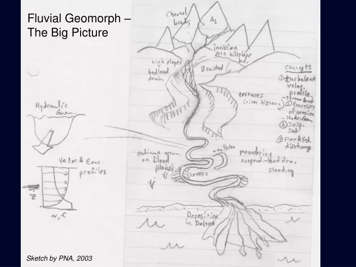
Fluvial Geomorph – The Big Picture. Sketch by PNA, 2003. Flooding.

E N D
Fluvial Geomorph – The Big Picture Sketch by PNA, 2003
Flooding During flooding, the stage in a river overtops the banks and spills out onto the floodplain, so the floodplain should be considered a part of the fluvial channel as well, even though it is utilized to convey flow less frequently than the main stem.
Effective Discharge of a Channel (curve b) Positive skew (or right-skew) distribution of event (discharge) frequency. Frequent small events, rare large events. But… (curve a) Sediment transport is non-linearly related to flow depth, speed, shear stress. So… (curve c) the product of the frequency and transport rate curves gives a peak value at a higher discharge than the peak in frequency, and is termed the effective discharge, or the channel forming discharge. For rivers, this event occurs with a recurrence interval of 2-3 years.
Nonlinearity of Suspended Sediment Transport Suspended load transport rate has been documented (Leopold and Maddock, 1953) to follow a power law dependence on water discharge where j is a value between 2-3, implying that a doubling of water discharge will increase sediment discharge by a factor of 4-8. Bed load transport, being that it is intimately tied to the thresholded process of incipient grain motion, is even more strongly non-linear (i.e. has a higher exponent).
Sedimentation on the Floodplain In a simplified sense, the only sediment that escapes the main thread of a channel during flooding, is that which is decanted from the suspended sediment concentration profile above the level of the channel banks. The suspended sediment profile decreases in its concentration of each particle size toward the top of the flow, hence only fines tend to escape. What's more, from the escaped waters, the coarsest sediment (the greatest volume) is deposited immediately adjacent to the channel to build the natural levee. This results in fining and thinning of floodplain sediments with distant away from the channel.
Natural Levee Development Channel area (m2) Channel area (m2)
Natural Levee Growth Mechanisms ADVECTION OF SUSPENDED SEDIMENT TURBULENT DIFFUSION OF SUSPENDED SEDIMENT
Inverse Power Law Fits to High End of Event Distributions (Molnar et al., 2006) Power (slope of log-log line) decreases with aridity
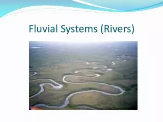
Alluvial River Planforms To understand what dictates the map-view pattern of a river, we need to explore processes governing local sediment erosion, transport, and deposition. The classic subdivisions of river planforms include the braided and meandering end members.
Braided River Notes Interesting aside: highly fluctuating flows may promote efficient removal of vegetation, which in turn maintains the “uncohesive” channel banks.
Braided Rivers – Numerical Model (Murray and Paola, 1994) Flow expansions and contractions drive divergence and convergence in sediment transport, which can be directly converted to bed aggradation or degradation via the Exner equation.
Scaling of meander wavelength and channel width – Self similarity
Scroll Bars record channel position through time Sinuosity of a meandering river is simply the ratio of channel length to valley length. Cutoffs can occur via chute cutoffs, or over-exaggeration of meander bends.
Meandering Rivers – Flow at Meanders Measurements at Muddy Creek, Wyoming by Dietrich et al., 1979
Numerical Modeling of River Meandering Lancaster and Bras (2002) have developed a numerical model of river meandering that illustrates the importance of chute cutoffs in limiting the sinuousity.
Oxbow Lake Scaling (Constantine and Dunne, 2008) Regarding the products of meander cutoffs, oxbow lakes have been found to follow a power-law relationship between their lengths and their sinuousity. This was done established with a simple Google Earth project.
AVULSION Evolution of the upper Columbia - 1952
AVULSION Evolution of the upper Columbia - 1966
AVULSION Evolution of the upper Columbia - 1976
AVULSION Evolution of the upper Columbia - 1988
AVULSION Evolution of the upper Columbia - 1995