Download
1 / 11
110 likes | 269 Views
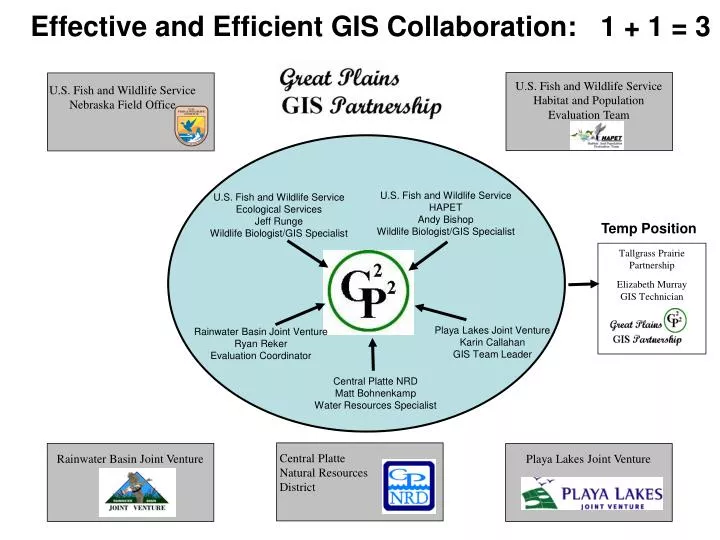
U.S. Fish and Wildlife Service Habitat and Population Evaluation Team. U.S. Fish and Wildlife Service Nebraska Field Office. Effective and Efficient GIS Collaboration: 1 + 1 = 3. U.S. Fish and Wildlife Service HAPET Andy Bishop Wildlife Biologist/GIS Specialist.

E N D
U.S. Fish and Wildlife Service Habitat and Population Evaluation Team U.S. Fish and Wildlife Service Nebraska Field Office Effective and Efficient GIS Collaboration: 1 + 1 = 3 U.S. Fish and Wildlife Service HAPET Andy Bishop Wildlife Biologist/GIS Specialist U.S. Fish and Wildlife Service Ecological Services Jeff Runge Wildlife Biologist/GIS Specialist Temp Position Tallgrass Prairie Partnership Elizabeth Murray GIS Technician Playa Lakes Joint Venture Karin Callahan GIS Team Leader Rainwater Basin Joint Venture Ryan Reker Evaluation Coordinator Central Platte NRD Matt Bohnenkamp Water Resources Specialist Central Platte Natural Resources District Rainwater Basin Joint Venture Playa Lakes Joint Venture
Working independently, each partner would need much of the same equipment. Working together provides tremendous sharing of knowledge and resources. Total G2P2 inventory = $125,300 Individual cost to provide basic resources for a GIS professional independently = $67,500 Total savings to partners by participating in G2P2 = $279,700 Great Plains GIS Partnership Inventory
Great Plains GIS Partnership Regionally-based… Biologically-driven… Landscape-oriented... Economically Efficient
Aerial Photography Partnership • Rainwater Basin Joint Venture • Central Platte Natural Resources District • US Fish & Wildlife Service • Nebraska Game & Parks Commission • Cornerstone Mapping, Inc.
Aerial Photography Coverage 1-Meter Resolution, Color-Infrared Imagery Fall 2003 Spring 2004 Fall 2004