Download
1 / 43
430 likes | 723 Views
Lesson’s learned from Typhoon Yolanda Response for EO applications in Asian Development Bank. Presentation by Yusuke Muraki Space Technology Specialist Asian Development Bank January 13 2014. Objective.

E N D
Lesson’s learned from Typhoon Yolanda Response for EO applicationsin Asian Development Bank Presentation by Yusuke Muraki Space Technology Specialist Asian Development Bank January 13 2014
Objective • To introduce needs of EO applications for disaster response in ADB based on the lesson learned from Typhoon Yolanda. • To trigger discussion how to meet such needs by the international cooperation.
Contents • Overall Yolanda Response in ADB • EO Applications for Yolanda Response in ADB • Lessons Learned
Introduction of ADB • Regional development bank • Economic development and Poverty reduction. • Projects • Loan, grant, and technical assistance (TA). • With knowledge to address development issues. • $15.3 billion assisted in 2013.
Introduction of ADB President Vice President Vice President Vice President Vice President Vice President HQ(External relations, audit, strategy .etc) Economics & Research Department East Asia Department South Asia Department Budget, Administration (Procurement, Human resources, Administration, Legal, .etc) Public/ Cofinance Central and West Asia Department South East Asia Department Regional Sustainable Development Department Pacific Department Headquarters in Manila, Philippines
EO applications in ADB • Letter of Intent with JAXA in 2010. • Sentinel Asia Data Analysis Node (DAN) since 2012. • Many projects applying EO. • Flood forecasting in Bangladesh, Philippines, Viet Nam (TA8074-REG) • Drought monitoring in Greater Mekong Sub-region (TA6521-REG) • Rice crop monitoring using radar in Lao P.D.R, Philippines, Thailand and Viet Nam (TA8369-REG)
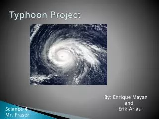
Overview of Typhoon Yolanda • Typhoon Yolanda (Haiyan) hit the central part of the Philippines on November 8 2013. • Wind speeds estimated at 315 km/h (195 mph). • As of January 10, 2014, 6,190 reported dead, 1,785 still missing. • 3.4 million family / 16 million persons affected. • 1.1 million housesdamaged.
Damage Assessment -> Plan • Multi-Cluster/Sector Initial Rapid Assessment (MIRA) • Reconstruction Assistance on Yolanda (RAY) based on Damage and Loss Assessment (DaLA)
Multi-Cluster/Sector Initial Rapid Assessment (MIRA) • Released on November 25, 2013 lead by UN OCHA with 45 organizations including ADB. • Methodology: Questionnaire and Sampling, Review of Government data source. • Rapid Assessment • Status of affected people, Damage and access to basic services such as Shelter, Water, sanitation and hygiene, Health, Livelihoods and Agriculture, Mass communication, Education, Displacement Management, Protection. • “Urgent and extensive shelter requirements” • With 515,179 houses totally destroyed and 551,546 partially damaged in the affected areas • “The most urgent needs are to replant the damaged rice and corn fields during present planting season.”
Reconstruction Assistance on Yolanda (RAY) • Government’s strategic plan for recovery and reconstruction prepared with the support of international partners including ADB, released on December 16, 2013. • Section III presents an estimate of the overall economic impact (damage and loss assessment (DaLA)), as well as an initial calculation of overall recovery and reconstruction needs.
Damage and Loss Assessment (DaLA) • Total damage: about US$12.9 billion. • Usually takes 6 weeks, completed quickly to meet the deadline of 2013 government budget mobilization. • Methodology: Handbook for Estimating the Socio-Economic and Environmental Effects of Disasters. United Nations Economic Commission for Latin America and the Caribbean, 2003. • Conducted using the best available data.
Damage and Loss Assessment (DaLA) • Targets • Infrastructure sector: Roads, Bridges, Flood control and government buildings, Ports, Airports, Electricity, Water Supply and Sanitation. • Economic Sector: Agriculture (Lands), Livestock, Fisheries, and Food Security, Trade, Industry, Services • Social Sector: Education (Schools), Health (Hospitals) and Nutrition, Housing and Shelters • Cross Sectoral: Local government and community infrastructure, Social impacts, Gender, Environment
Timing 11/8 11/13 11/25 12/06 12/13 12/16 Typhoon Yolanda 3 million $ Grant approved 20 million $ Grant and 500 million $ Loan announced MIRA released 20 million $ Grant concept prepared 500 million $ Loan approved 20 million $ Grant approved 375 million $ Loan approved DaLA completed and RAY released
1) Needs • Assessment Phase • Damage assessment for (i) designing the loan and grants, and (ii) making MIRA and DaLA. • Number/area of damaged infrastructure/lands by its type • Location/spatial distribution of the damaged infrastructure/lands • Implementation phase (Reconstruction) • Prioritization of reconstruction • Distribution of damages • Combination with GIS analyses
2) What ADB has done • Accessed International Disaster Charter, Sentinel Asia and other available EO information and sharedin the Yolanda Response Team in ADB. • Counted damaged infrastructure based on damaged infrastructure map based-on satellite imagery and basic GIS data from Open Street Map (OSM). • Identified of number of damaged houses in 40 m buffer zone from the coast line for understanding the magnitude of the replacement. • Asked satellite providers to provide proposal for damage assessment.
Damage assessment GIS Analysis Image from International Charter Image from Openstreetmap Base maps (Layers of houses, infrastructure, roads, etc.) Damaged infrastructure by visual check of satellite imagery Data Source -Open Street Map • Number of damaged infrastructure • Damaged infrastructure maps Data Source -Open Street Map
Could calculate the number and locate the damaged hospitals, hotels, schools, etc. on maps
Observation from the initial results • Number of damaged houses for Tacloban city from the results was 20166 / 33351 (60%) • Number of damaged houses for Tacloban city reported in NDRRMC update was; • 382 for 11/10 to 11/21 • 58,823 (12,270(Totally), 46,553(Partially)) for 11/21 to 12/20 Satellite-based assessment has advantage for the quick assessment until field data is available
Estimation of number of houses in 40 m buffer zone from the shoreline
3) Potential applications • Damage assessment using agricultural lands using satellite data. • Damage assessment for the infrastructure for other affected areas.
Lessons Learned <Challenges for information creation> • Lack of basic GIS dataset for overlay with satellite-based damaged infrastructure maps • Difficulty to access to high-res. satellite imagery for damage assessment purposes • Lack of coordination in data analysis contribution <Challenges for information utilization> • The numbers based on satellite data can’t be used in official reports easily
1) Lack of basic GIS data GIS Analysis Image from International Charter Image from Openstreetmap Basic GIS data (Layers of houses, infrastructure, roads, etc.) Damaged infrastructure by visual check of satellite imagery Available from space community Not easily available!! • Number of damaged infrastructure • Damaged infrastructure maps
1) Lack of basic GIS data • Difficult to get basic GIS data from the government agencies after the disaster. • Should make mechanism to prepare such GIS dataset for sharing with international partners before disasters. • Lack of necessary data in the government. • Support to prepare data. • Making use of Open Street Map (Crowd source) data. DPN (Space) DAN User DPN (Basic GIS) Example in Sentinel Asia
Potential collaboration with OSM • Open Street Map is volunteer-based project to create free editable map of the world. • Humanitarian OSM team has started making base map around the affected area from Nov. 6 (Before the Typhoon hit.) • OSM maps have building attribution checked by the local volunteers. • The World Bank has started project in the Philippines to support the local government unit to make use of OSM maps for their operation.
2) Availability of High Res. Satellite data for damage assessment • The coverage of satellite imagery provided through the International Charter and Sentinel Asia was not enough for the whole affected area. • More coordination in data providers. • Widen the scope of free data sharing. • Establishment of mechanism to purchase satellite data for the whole affected area soon after disaster happens. • The window that DAN can access the data from international charter was too short.
3) Lack of coordination for data analyses • It was difficult to know what geospatial processing other agencies were conducting, which made ADB’s decision making much slower to decide where and what to focus. • More coordination in international community during disaster events.
4) How to make use of satellite-based information • It is difficult to change official numbers reported from fields or responsible local government agencies at the higher level. • It is important to consider how to make use of satellite-based information at the level of agencies which create numbers as initial data source.
Conclusion • EO is useful in the event of disaster not only for initial rescue purposes, but also for the quick damage assessment for the government and donors to mobilize funds and decide budget allocation. • However, it is still underutilized for this purpose. ADB would like to discuss how to realize this with the international partners.
Thank you!If you have any questions, please contactYusuke Murakiymuraki@adb.org