Download
1 / 20
200 likes | 366 Views
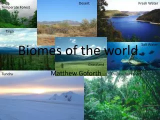
Biomes of the World. Classified based on temperature, precipitation and adapted plants and animals for the region. Shrubs and sedges- extreme winters with very short growing season. Needle-leaf evergreens for short growing season and tough winters.

E N D
Biomes of the World Classified based on temperature, precipitation and adapted plants and animals for the region.
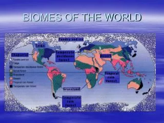
Shrubs and sedges- extreme winters with very short growing season. Needle-leaf evergreens for short growing season and tough winters Grasslands due to too little moisture for woody plants Arid shrub/thorn scrub of the hot and dry desert Deciduous- seasonal leaves due to colder winters Broadleaf evergreen- lots of sunlight and moisture Tundra Coniferous Forest Grasslands Desert Deciduous Forest Tropical Rainforest
Tropical Rainforest • Warm and wet -250cm of rain per year to about 450 cm/year. The average annual temperature is above 20° C (never a frost) • tropics, a band around the equator from 23.5° N (the Tropic of Cancer) to 23.5° S (the Tropic of Capricorn) • Highest biodiversity; over 7900 in one forest and especially 90% of all primates live here. • The warmth leads to a lot of evaporation, and as warm, moist air rises, it cools, the water condenses, and the water falls back to the earth as rain. • Threats-animal poaching, sustenance farming, human population growth, Industrialized agriculture, logging and other minerals and resources being removed for human use.
Tropical Rainforest • Tropical forest is broken up into FIVE distinct forest layers. • The buttresses from the large emergent trees support the height of these enormous trees. • Poor soil due to chemical weathering from moisture and from so much vegetation removing the nutrients from the soil. • Found along equatorial zones. Buttress roots
Savanna • The term savanna or campos or llano was originally used to describe the treeless areas of south America. • The climate of the savanna is consistently warm and has two distinct seasons; wet and dry seasons. • Covered with less woody trees, with the exception of the Acacia Tree, and has more grasses and shrubs due to less rainfall. • Subject to recurrent fires, the dominant vegetation is fire adapted. Acacia trees
Savanna • The largest Savanna in the world is in Africa and surrounds the rainforest. • Savanna animals are mostly herbivore, grazing packs of animals (60 different types) along with the herd predators such as lions, crocodiles, wild dogs and cheetahs. • Threats: Global climate change (warmer and less rain), agriculture, mining and poaching.
Grasslands • Dry climate 25-80cm of precipitation a year. • Also, grasslands tend to be in temperate to subtropical areas, often with cold winters and hot summers. • Found between deserts and forests. • In the northern hemisphere the main grasslands are the prairies of the mid-western United States and Canada; in Eurasia the maker grasslands are the steppes of Russia and the grasslands of the mid-east extending from Turkey to India. Grasslands are also found in South America. • A wide range of herbivores once roamed these regions, mostly ungulates (hooved animals).
Grasslands • There are three main types of dominant plant species; tall-grass, mixed-grass and short-grass prairie • Australia has four types of grasslands based on amount of precipitation. • 42% of the Earth used to be grasslands, now less than 12% remains due to conversion to croplands. • Threats: There are two major threats to grasslands - conversion to agriculture (or urban areas) and global warming and its attendant changes in precipitation. Also, mining, animal poaching and development Corporate Farming Cattle industry
Desert • These arid regions occupy 25-35% of earth’s landmass. • Temperate deserts have very hot summers and winter nights can be extremely cold. Temperate deserts lie in the rain shadows (Climate PP). • Cool deserts have warm summer and cold winters. • Hot deserts are equatorial with extreme heat year round throughout the day but can have extremely cold evenings due to lack of cloud cover. • Polar Desert- Antarctica and the Arctic are extremely cold deserts with very little annual precipitation. • Sahara is the world’s largest and covers approximately 9 million km2 of N. Africa. • Australia is classified as 40% desert.
Desert • Precipitation is low, less than 12 cm per year • The average annual temperature is less than 10° C. • subtropical deserts- latitudes of 30° North or South latitude (equator) • Temperate deserts- "grassland" from "desert". • Locations from southern California, North/central Africa, Central Asia and central Australia • Threats-one of the biggest threats to deserts is development (Now that we have learned how to divert water; Ex: Las Vegas) and animal poaching. Subtropical deserts Technically the poles are classified as deserts because they receive under 12 cm of snow yearly Temperate deserts
Mediterranean Shrub lands or Chaparral • Most lie between 30 and 40° latitude. • The climate is hot, drought-like summers and cool, moist winters. • The are five regions of Mediterranean ecosystems including the semiarid of W. US (Such as Southern California), Mediterranean Sea, Central Chile, cape of S. Africa and SW Australia. • The Chaparral is the shrub community in N. America. • About 65% of the precipitation falls during the winter months. • Animal life ranges from mule deer, coyotes, many birds, as well as kangaroos and wallabies.
Mediterranean Shrublands • Vegetation includes broadleaf evergreen shrubs and dwarf trees known as sclerophllous (small leaves and hairy stems). • Largest regions surrounds the Mediterranean Sea. • The Mediterranean shrublands lack an understory and ground litter and are therefore very flammable. • Fires are part of the cycles of the shrubs, after the fires regrowth matures and prepares for the next fire. • Threats- Over development due to its extremely sunny and pleasant climate and forest fires.
Temperate Deciduous Forests • In N. America, the deciduous forest consists of several types ofbroad o flat-leaf trees such as; Oaks, Maples, Cherry Trees, Dogwoods, Birches as well as a wide variety of ferns, flower plants and shrubs. • The N. American deciduous forest extends from New York to Tennessee and even northern Louisiana and Mississippi. • There are also Asiatic broadleaf forests in eastern China, Japan, Taiwan and Korea; as well as in New Zealand, Tasmania, southern Australia.
Temperate Deciduous Forest • Very hot summers to very cold winters. • The average annual temperature ranges up to about 20° C down to freezing. • Precipitation ranges from around 50 cm yr in the colder regions to over 200 cm/yr. (lake-effect snows in the winter-until the lake freezes). • Broad-leaf vegetation; large and flat leaves with a shrub layers and ground layer of herbs, ferns, and mosses. • Animals include small herbivores, deer, bear, rabbits, mice, salamanders and several types of birds as well as predators such as mountain lions, foxes, bears and venomous snakes. • Threats- Acid Rain, logging, human population and development, global warming also the soils are rich and easily converted to agriculture
Taiga or Boreal Forest • Climate in the taiga is cold, with average annual temperatures from about +5° to -5° C • 20 cm of precipitation per year to over 200 cm • Growing season is short, usually less than 3 months. • Broad bands across North America and Eurasia (Russia/Siberia) • Coniferous trees • Threats-animal poaching, exploration and development of oil and natural gas reserves, development and logging is always a threat however, most serious threat is Global Warming which is causing death to the trees and is changing the forest to a Tundra.
Tundra • In the tundra, conditions are cold, with an annual average temperature less than 5° C, and precipitation (mostly in the form of snow) less than 100mm per year (see figure at right). • The summer is brief, with temperatures above freezing lasting for only a few weeks at most. • The ecology of the tundra is controlled by the cold climate and the northern latitude. The former means that a unique soil structure, permafrost, forms and dominates the biology. • Lichens and mosses,willows, sedges and grasses • Other Threats-airborne pollutants, oil and gas development , global warming