Download
1 / 44
440 likes | 546 Views
Piloting Session Five. Santa Barbara Sail and Power Squadron Fall 2006. Outline. Homework SG Ch. 4 pp. 3 - 6 GPS pp 7- 43. Homework Ch. 4. 195 0. 015 0 W. 030 0. 034 0. 212 0. 109 0. 215 0. 074 0. 354 0. 056 0. 330 0. 8 0 W. 3 0 W. 05 0 W. 5 0 E. 010 0. 318 0. 228 0.

E N D
Piloting Session Five Santa Barbara Sail and Power Squadron Fall 2006
Outline • Homework SG Ch. 4 pp. 3 - 6 • GPS pp 7- 43
1950 0150 W 0300 0340 2120 1090
2150 0740 3540 0560 3300 80 W 30 W 050 W 50 E 0100 3180 2280 0890 0200 0090 1340 20 E 10 W 10 W 10 W 20 W 00 10 W 10 E 20 E 20 W 10 W 0210 0460 2230 1800 1390 0110
GPS • Buttons • Screens • Operations
Outline SG Ch. 5 • Objectives • Using GPS As a Navigation Tool • What GPS Can Do • GPS Receiver Keyboard Functions • Typical GPS Screens • Entering Waypoints Into the GPS • What the GPS Does When You Select a Waypoint • Navigating Using GPS and Waypoints
Objectives • Using GPS As a Navigation Tool • GPS Keyboard Functions • Typical GPS Screens • Constructing Routes • Checking Waypoints and Routes Stored in GPS • Activating Waypoints For Navigation • What the GPS Does when a Waypoint Is Activated • The Process of Navigating With GPS • Plotting Your GPS Position On a Chart
Using GPS As a Navigation Tool • GPS Without Charting Software • Like Using Loran: It will give you position on the water: then need to plot on a paper chart • Like Loran, could store waypoints on GPS for use while on the water • GPS With Charting Software • Like a Chart-plotter • Can Pre-Plan • Can punch in waypoints while on the water and GPS will show track. Can build routes
What GPS Can Do • Provides position: L and Lo • Can calculate a course to steer between waypoints • It can calculate estimated arrival time, ETA
What GPS Cannot Do • Warn of hazards (USPS) • Translation from USPS: You have to look on a chart to see if the course is safe • Actually it has a proximity warning function • Determine water depth
GPS Keyboard Functions • Power Button: On/off • Cursor Key: rocker switch • Enter Button/ Mark: Yes; enters current waymark (on the water) • Menu Button • Quit Button: like an escape key or back button • Go To Button • Page Button • MOB Button: Man Overboard • Zoom Buttons
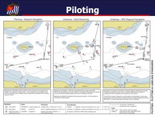
Typical GPS Screens • Satellite Screen • Position Screen • Map Screen • Highway Screen • Compass Screen • Menu Screen
Meet Your GPS, WN P. 49 Satellite/Position Screen Map Screen Highway Screen
Operation: Getting to Satellite Page Power key Page key Welcome Page Information page Warning Page Page key Page key Satellite Page
Page On
Entering Waypoints Into the GPS • On the Water: hit the Mark key to enter the current location as a waymark • Use digital charts and pre-planning to determine location of waypoints and then enter L and Lo into GPS • Choose waypoints on a paper chart and use dividers to measure L and Lo for entry into GPS
Page On Mark “ On the Water entry”
MapSource Software: “Computer Pre-planning Entry” Waypoint tool L & Lo Select Buoy
Entering Waypoints Loran C Plot On a Paper Chart L & Lo GPS w/o Chart Plots Waypoints On the GPS For You GPS with Chart Software (handheld Chart-Plotter)
Operation: Simulation Mode Satellite Page (off the water) Menu key Select Start Simulator Map Page Page key Enter key Select map position using cursor (white arrow) with rocker
L & Lo “SB” Bell Move white cursor over the object and Press enter to get buoy page
“Sb” Buoy Page Press menu key to get Save as Waypoint option
Press enter to get New Waypoint Page
Press enter key returns you to buoy page; then press page key to go to map page. Note Waypoint is denoted “SB” while the buoy is “Sb”
SB Waypoint overlaid On Sb buoy To check waypoints from here, Press menu key twice to go to Main menu
Select Waypoints to see list of waypoints
Then press enter key To go to “SB” Waypoint Page
Options: • With rocker arm you can • View on map page • 2. delete
What the GPS Does When You Select a Waypoint • GPS compute course to new waypoint, including bearing and distance from current location • Plots a line of the activated course on the Map Screen • Creates a highway on the Highway Screen
Exercise 2-2: Bowditch Bay Ex.4-1