Download
1 / 23
240 likes | 383 Views
Dead reckoning, piloting. John Huth. Topics. Measuring speed of boat Currents Leeway Errors from dead reckoning Piloting Curvature of the earth Landfall. Forces on boat. Wind Resistance on hull Current Lee-way (wind on sailing vessel). Forces on a sailboat, and resultant motion.

E N D
Dead reckoning, piloting John Huth
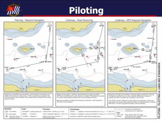
Topics • Measuring speed of boat • Currents • Leeway • Errors from dead reckoning • Piloting • Curvature of the earth • Landfall
Forces on boat • Wind • Resistance on hull • Current • Lee-way (wind on sailing vessel)
Forces on a sailboat, and resultant motion Direction of motion Leeway Steering direction Drag Lateral force from keel Wind
A big factor in hull resistance is caused by the bow wave and stern wave, creating a wake. The number of wavelengths between the bow-wave and stern-wave partly determines resistance. A good navigator can estimate hull speed from the shapes of the bow wave and stern wave.
Estimating speed relative to water Boat length L Start counting now Piece of flotsam in water Stop counting now Speed is L/time
Ships log (or chip log) The log gets thrown over the stern of the vessel – as the line gets played out, sailors count the number of knots that pass the stern for a fixed period of time. (where the term “knot” for “nautical mile” comes from). This can be easily improvised.
How Polynesians estimated currents Current direction Initial bearing Initial position Final bearing Position after drift
Estimating leeway “Slick” of calmer water Wake is tilted Water piles up higher on bow
Compensating for leeway and current Current Desired heading Leeway Actual motion Direction of travel
Example: compensating for current in a blind crossing Current draining bay = 1 knot Heading we chose Desired heading Speed = 4 knots
Errors (uncertainties) in position in dead reckoning Uncertainties in speed and heading are typically a fixed percentage – so, as a journey progresses, the numerical uncertainty in position gets larger as time goes on error -12o Uncertainty in heading Desired heading error +12o Uncertainty in speed
Expanding the target of landfall Color of the sea Birds Clouds Mountains
Color of the sea • Deep sea is typically a dark blue • Reflects the color of the sky, plus absorption • Depends, in part on content of algae • Color in shallower waters are a combination of factors • Color of the water itself • Color of the bottom (sand, rock, etc) • Examples • Tropical waters can be azure
Importance of local knowledge: satellite photo of Black sea and Mediterranean
Range formula for objects Curvature of the earth causes objects to be hidden by the horizon D = distance of object in nautical miles H=height of object in feet h= height of observer in feet D
Sequence: approaching an island Far distance – deep blue color
Sixty miles out – spot non-pelagic birds, steer toward land