Download
1 / 57
630 likes | 793 Views
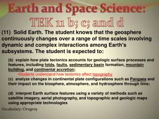
TEK 8.9 Earth and Space. The student knows that natural events can impact Earth systems. The student is expected to: 8.9 A) Describe the historical development of evidence that supports plate tectonic theory. 8.9 B) Relate plate tectonics to the formation of crustal features.

E N D
TEK 8.9 Earth and Space The student knows that natural events can impact Earth systems.
The student is expected to: 8.9 A) Describe the historical development of evidence that supports plate tectonic theory. 8.9 B) Relate plate tectonics to the formation of crustal features. 8.9 C) Interpret topographic maps and satellite views to identify land and erosional features and predict how these features may be reshaped by weathering.
8.9 Vocabulary Continental Drift Pangaea Plate Tectonics Mountain Building Volcano Erosion Lithosphere Seafloor spreading Divergent plate boundary Trench Topography Weathering Mid-Ocean Ridge Topographic map Asthenosphere Convergent plate boundary Transform boundary
Science Starters…Watch This! The Himalayas The Ring of Fire Tsunami San Francisco Earthquake
The Theory of Continental Drift -proposed by Alfred Wegner 1912 -states that all the continents were once connected in a single, large land mass -broke apart 200 million years ago and drifted slowly to their current positions -moving 1-10cm per year
Pangaea • Large ancient land mass that was composed of all the continents joined together. • Greek meaning “all land”
Evidence of Continental Drift • Pieces of a Puzzle • Fossil Record (similar fossils found on different continents) • Rock Type and Structure(similar rocks found on different continents) • Climate (fossils of plants and animals not suited for current climate of continent)
The Theory of Plate Tectonics -proposed by Harry Hess in 1960’s -describes and explains the way that continents separated into today’s land masses from Pangaea (one large ancestral land mass).
Lithosphere -the outermost layer of the Earth’s surface, which is rocky and solid. -includes the crust and the rigid part of the upper mantle. -Includes the tectonic plates that move on semi liquid mantle
**Asthenosphere** Scientists believe that convection currents within the asthenosphere are responsible for the movement of the plates that form the Earth's crust.
Watch This Continental Drift Bill Nye Layers of the Earth
The student is expected to: 8.9 A) Describe the historical development of evidence that supports plate tectonic theory. 8.9 B) Relate plate tectonics to the formation of crustal features. 8.9 C) Interpret topographic maps and satellite views to identify land and erosional features and predict how these features may be reshaped by weathering.
Divergent Boundary • “Di-”meaning two • Boundaries in which plates move apart • Results in a Rift Valley or Mid Ocean Ridge
Seafloor Spreading -Theory proposed by Harry Hess 1960 -States that new seafloor is formed when magma is forced upward toward the surface at a mid-ocean ridge. • Divergent boundaries
Mid Ocean Ridge -an underwater volcanic mountain range -typically has a valley known as a rift running along its spine
Convergent Boundary -“con-” meaning together -Boundaries that come together -results in mountain building
Convergent Boundary (subduction) -the process in which one lithospheric plate slides under another -can result in volcanoes and a trench.
Transform Boundary -Boundaries run transversely to each other. • Slide past each other -Creates fault lines • Origin of earthquakes
B A IV I D II III C
The student is expected to: 8.9 A) Describe the historical development of evidence that supports plate tectonic theory. 8.9 B) Relate plate tectonics to the formation of crustal features. 8.9 C) Interpret topographic maps and satellite views to identify land and erosional features and predict how these features may be reshaped by weathering.
Topographic Map A topographical map is one that shows the physical features of the land. Besides just showing landforms such as mountains and rivers, the map also shows the elevation changes of the land. Elevation is shown using contour lines.
Contour line (contour) -connects points of the same elevation (height above sea level). -closed contours indicate hills.
Contour interval -difference in the elevation between any two contour lines on a topographic map
Slope Contour lines spaced far apart Shallow slope Contour lines spaced close together Steep slope Contour lines spaced evenly Constant slope
Index contour - a contour line that is darker than nearby lines and has its elevation labeled.