Download
1 / 28
490 likes | 817 Views
Differential GPS. An Introduction. How does it work. Method of Differential Correction. The reference ground station(s) at known locations receive NAVSTAR signals. Knowing position of the station, the pseudo-range to each SV is calculated based on the almanac

E N D
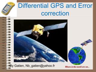
Differential GPS An Introduction
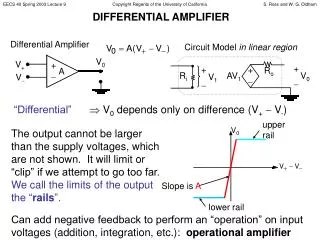
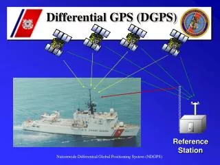
Method of Differential Correction • The reference ground station(s) at known locations receive NAVSTAR signals. • Knowing position of the station, the pseudo-range to each SV is calculated based on the almanac • The measured pseudorange, PRM(t), is determined • The pseudorange correction is calculated as the difference • The pseudorange correction, PRC(t), and the Range Rate Correction RRC(t) are sent from the reference ground station
Method of Differential Correction • Local GPS calculates corrected position Corrected pseudorange = pseudorange measured + pseudorange correction PR(t) = PRM(t) + PRC(t)
Local GPS Communications • NMEA 0183 used to communicate fix data from GPS devices • Serial character data • Baud Rate 4800 • Data Bits 8(d7=0) • Parity None • Stop Bits One(or more) • RTC SC 104 used to communicate differential data • Serial character data
Typical System Diagram Vehicle Mounted GPS Unit
RTCM SC 104 • Specification for the signal used to transmit differential correction to a GPS ground receiver • Format is referred to as the RTCM-104 format (Radio Technical Commission for Maritime Services Special Committee No. 104)
NMEA 0183 Example • Global Positioning Fix Data • $GPGGA,120757,5152.985,N,00205.733,W,1,06,2.5,121.9,M,49.4,M,,*52 • Synopsis: • time of fix (hhmmss) • latitude • N/S • longitude • E/W • Fix quality (0=invalid, 1=GPS fix, 2=DGPS fix) • number of satellites being tracked • horizontal dilution of position • altitude above sea level • M (meters) • height of geoid (mean sea level) above WGS84 ellipsoid • time in seconds since last DGPS update • DGPS station ID number • checksum
GPS – How it works • Constellation of more than 24 satellites • Known positions (at any time) • Each continuously transmits time and position data • Two frequencies (L1-1575.42MHz and L2-1227.6MHz) • Each orbits twice per day • Ground receiver (Your GPS receiver) • Calculates Position and Time • Times signal and calculates distance to each satellite received • Triangulates Latitude and Longitude • Calculates time • Must see a minimum of 4 satellites
Differential GPS • Differential GPS is required for guidance • Without differential corrections, precision is ± 100 ft. • With corrections ±3 ft, ±4”, ±0.3” • Method: • Nearby ground station at known position uses GPS to determine errors in distance to satellites • Errors are sent to roving GPS units • Issues • Where do you get the correction signals? • Coast Guard • Omnistar • Deere • WAAS • Local Beacon
GPS Error in Corn – Loss of Differential Correction Signal Oklahoma Panhandle, 1998
Coast Guard Beacon Coverage http://www.navcen.uscg.gov/dgps/coverage/CurrentCoverage.htm
Deere Starfire™ SBAS John Deere’s StarFire System: WADGPS for Precision Agriculture Tenny Sharpe, Ron Hatch, NavCom Technology Inc.; Dr. Fred Nelson, John Deere & Co.
Circular Error of Precision http://trl.trimble.com/docushare/dsweb/Get/Document-209836/MGISWAASWhitePaper_0105.pdf
Differential correction sources Source Cost URL Terrestrial differential correction USCG Beacon Free users.erols.com/dlwilson/gpswaas.htm User provided ? Self SBAS (Satellite based Augmentation System) Omnistar $800/yr www.omnistar.com/faq.html OmnistarHP $1500/yr www.omnistar.com/faq.html Deere Starfire1 $500/yr StarFireGlobalHighAccuracySystem.pdf Deere Starfire2 $800/yr StarFireGlobalHighAccuracySystem.pdf WAAS Free users.erols.com/dlwilson/gpswaas.htm
RTK Base Station • Decimeter to Centimeter accuracy • Range • 12 miles decimeter • 6 miles centimeter BEELINE Base Station
GPS Technology vs. Precision(New Holland IntelliSteer ™ ) • 1. DGPS • Differential correction signal provided by free WAAS service. • Typical accuracy: +/- 10 inches • 2. DGPS VBS (Virtual Base Station) • Differential correction signal provided by OmniSTAR subscription. • Typical accuracy: +/- 10 inches • 3. DGPS HP (High Performance) • Differential correction signal provided by OmniSTAR™ subscription. • Typical accuracy: +/- 4 inches • 4. RTK (Real Time Kinematics) • Differential correction signal provided by base station. • Typical accuracy: +/- 1 inch • http://www.newholland.com/h4/products/products_series_detail.asp?Reg=NA&RL=ENNA&NavID=000001277003&series=000005423311
GPS Receiver Types • Low cost GPS • Example: Handheld GPS • Receiver Channels – 12 • Position update rate 1 per 5 sec. • Likely to provide WAAS differential • Precision probably not better than ~ 5’ • Data output may or may not have NMEA 0183 output • Mapping quality GPS (Simple DGPS) • Example: Trimble AgGPS 132 • Receiver channels – 12 • US GPS/EGNOS capability • Position update 10 per second • WAAS, C. G. Beacon, Omnistar/Racal SBAS • Precision better than 3 ft • Data Output, NMEA 0183 (Serial) + CAN
GPS Receiver types • High Precision differential GPS • Example Deere Starfire-2 • Receiver channels 20 GPS, 2 SBAS both L1, L2 freq. • US GPS/EGNOS capability • Position update 5 to 50 per second • WAAS, Deere SBAS • Precision better pass to pass 4” • Data Output, NMEA 0183 (Serial) + CAN • Slope compensation
GPS Receiver types • RTK GPS • Example: Trimble Ag GPS 252 • Receiver channels – 24 • US GPS/EGNOS capability • Position update to 10 per second • WAAS, OmnistarHP, RTK • Pass to pass accuracy 0.3” to 2” • Data Output, NMEA 2000 ISO 11783 CAN • Requires user provided base station • 2 x $8000 + $3000 lightbar + radio link • Within 6 mi. radius line-of-site
How to determine Health of the NAVSTAR and Coast Guard Systems • Check the Coast Guard web site for status • http://www.navcen.uscg.gov/ • WAAS – Wide Area Augmentation System • http://gps.faa.gov/Programs/WAAS/waas.htm