Download
1 / 16
160 likes | 303 Views
Metadata in the IOOS Community. Julie Bosch NOAA Coastal Data Development Center QARTOD III November 2–4, 2005. Overview. Definition of Metadata Community Metadata Activities MMI COTS/ONR QARTOD Discipline-specific workshops NOAA/NAVY Interoperability Demonstration

E N D
Metadatain theIOOS Community Julie Bosch NOAA Coastal Data Development Center QARTOD III November 2–4, 2005
Overview • Definition of Metadata • Community Metadata Activities • MMI • COTS/ONR • QARTOD • Discipline-specific workshops • NOAA/NAVY Interoperability Demonstration • IOOS DMAC Metadata Expert Team • Status • Plans • Post-Katrina metadata model QARTOD III November 2-4, 2005
A Definition of Metadata The information needed to identify assess use access exchange transport archive data for IOOS QARTOD III November 2-4, 2005
Marine Metadata InteroperabilityProject (MMI) • Contributions form the marine data community • Growing resource for marine metadata information • Content Standards and Profiles • Vocabularies and Ontologies • Transport Protocols • Guides • Examples • Tools • Submitted vocabularies include parameter use and parameter discovery vocabularies • www.marinemetadata.org QARTOD III November 2-4, 2005
Marine Metadata Interoperability MMI Workshop on Advancing Domain Vocabularies (August 2005) • OWL files generated for over 40 existing vocabularies • Breakout groups initiated development of domain ontologies (relating vocabularies) using VINE tool Waves Sensors and Instruments Chlorophyll Units CTD Measurements Benthic Habitat Classification • Demonstration of interoperable data access using metadata and a vocabulary mapping ontology QARTOD III November 2-4, 2005
COTS/ONR Project • Metadata Working Group • Developed a work plan to develop metadata to assist in enabling the IOOS Interoperability Demonstration (part 2) • Plan focused on determining/developing controlled vocabularies and providing metadata guidance for data including winds, SST, waves, surface current and chlorophyll • Aggressive time-line for completion • Metadata work plan segment of COTS/ONR Project not implemented QARTOD III November 2-4, 2005
Quality Assurance Real Time Ocean Data (QARTOD) QARTOD I – December 2003 • Metadata requirements • General QA/QC flags be defined • Specific test used for QA/QC be defined • Pros and cons of existing standards discussed QARTOD II – February/March 2005 • Discipline specific metadata needs identified • Waves, in-situ currents, remote currents Post QARTOD II • Progress on waves metadata • NDBC and CDIP - FGDC wave metadata generation • Additional work to be done on incorporating the How and What of QC into metadata QARTOD III November 2-4, 2005
Workshops Discipline specific workshops (CSC and NDBC) • Salinity (August 05) • QC for real-time salinity measurements • Drafted metadata record example of salinity data attributes • Waves (November 05) • Significant advancements on QC requirements and recommendations • Identification of details that need to be captured in metadata Results include identifying best practices for continuing the discipline specific approach What’s next? CTD, HF Radar, Chlorophyll,…? QARTOD III November 2-4, 2005
NOAA/Navy IOOS Interoperability Demonstration Data Discovery/Access Lessons Learned • Determining the best (reasonable) sources of data for the demonstration was a time consuming process and required extensive domain expertise and contacts with individual data providers, pointing to the lack of accessible metadata. QARTOD III November 2-4, 2005
NOAA/Navy IOOS Interoperability Demonstration Metadata Recommendations • Standards must be established that will define the minimum set of common information that must be included with data submitted for use in the IOOS community. • FGDC compliance is required but present standards do not address most IOOS data to allow functional discovery and access. QARTOD III November 2-4, 2005
IOOS DMAC Metadata Expert Team Co-Chairs: Anne Ball (CSC) and Julie Bosch (NCDDC) Team Members • Plan for 10-12 members representing various organizations and disciplines • 8 team members currently nominated Organizations • NASA - NFRA (IOOS) • OBIS - NOAA • MMI - ORION • International - EPA • Research Institutes (WHOI, UA) - USGS • FGDC, ISO - Private Industry QARTOD III November 2-4, 2005
Goals Liaison and coordinate with related organizations and activities in order to determine: • Content requirements • Appropriate standard(s) • Implementation of the standard(s) • Metadata exchange • Data discovery tools Make recommendations to the steering team based on these findings Provide a publicly accessible forum with information including metadata examples, templates, and tools for IOOS participation QARTOD III November 2-4, 2005
Key Team Activities • Research metadata standards being used for coastal and ocean observations • Engage data collectors, users, and modelers to identify the information needed to discover, use, understand, access, transport, exchange, and integrate observational data • Develop templates and profiles of metadata QARTOD III November 2-4, 2005
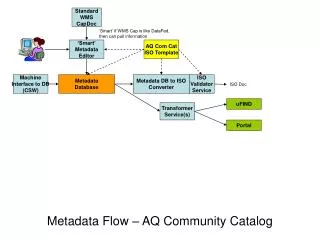
Post-Katrina Model of Metadata Ontologies Data Types Format Specifications Controlled Vocabularies Metadata Standards Discovery Systems QARTOD QC Flags Metadata Transport
Parting Thoughts Examples of basic metadata for CDT, HF Radar, and Wave data are available During QARTOD • Identify and note specific QC details that need to be captured as part of the metadata QARTOD III November 2-4, 2005
Julie Bosch NOAA Coastal Data Development Center Stennis Space Center, MS 228-688-3841 julie.bosch@noaa.gov QARTOD III November 2-4, 2005