Download
1 / 9
90 likes | 103 Views
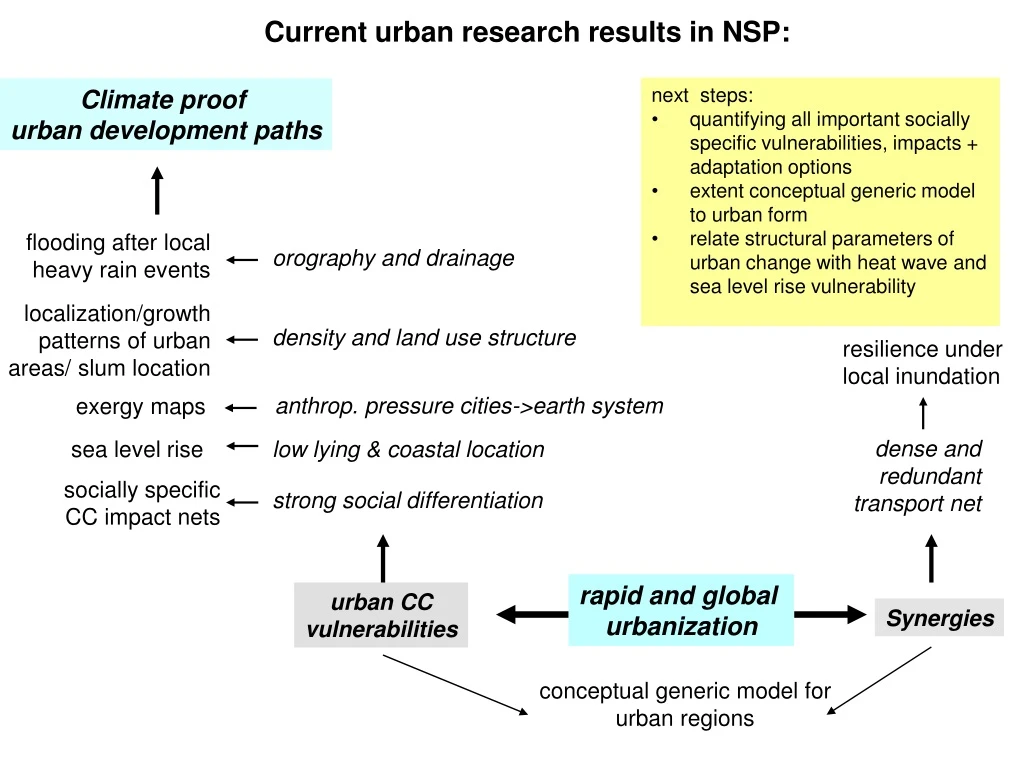
Current urban research results in NSP:. next steps: quantifying all important socially specific vulnerabilities, impacts + adaptation options extent conceptual generic model to urban form

E N D
Current urban research results in NSP: • next steps: • quantifying all important socially specific vulnerabilities, impacts + adaptation options • extent conceptual generic model to urban form • relate structural parameters of urban change with heat wave and sea level rise vulnerability Climate proof urban development paths flooding after local heavy rain events orography and drainage localization/growth patterns of urban areas/ slum location density and land use structure resilience under local inundation anthrop. pressure cities->earth system exergy maps dense and redundant transport net sea level rise low lying & coastal location socially specific CC impact nets strong social differentiation rapid and global urbanization urban CC vulnerabilities Synergies conceptual generic model for urban regions
Endangered urban areas under extreme precipitation: flow accumulation Research results: • Estimation of frequency increase of climate-change induced extreme precipitation events • Orography-derived, remote Sensing based flow accumulation model Kit et al., 2010 Climate-proofing measures: • Restriction of development in identified areas of high flow accumulation • Preventive extension of drainage system Hyderabad, from 17 AOGCMs (Lüdeke et al., 2010)
Greater London City Clustering Algorithm based on population density administrative city cluster (Rozenfeld HD, Rybski D, PNAS 2008) • Results: • different definitions of cities affect statistical properties of urban activity • Zipf's law holds over many decades • scale-invariant growth features • long-range spatial correlations in growth • Climate-proofing: • application of these structural properties to predict the cities vulnerability, e.g. towards heat waves or coastal floods • targeted preventive action
Regional Urban Growth Patterns • Annual growth: • fastest in China (1.5-2%) and Latin America- 1%- both independent from density • Europe: cities < 2 mln will grow: Less density - more growth potential • China and Europe - same number of mega-cities • Expect the number in China to increase 2-3-times • Cities larger then 5 mln: • each region different => global economy, not demography laws • Disperse city-> lower emissions per area • Compact city-> lower emissions per person. Svirejeva-Hopkins, 2010. “ City Size, Density and Sectoral Structure: exploring Urban Sustainability in the Regions. EGU
Slum areas endangered by flooding Research results: automatic slum area identification (lacunarity) from remote sensing (Bird Eye) for different time slices vulnerability of urban slum areas in Hyderabadtowards heavy rain fall events Climate-proofing measures: Integration of slum identification procedures into urban planning process Inclusion of secure low cost housing in urban development plans Light to dark blue: water flows under heavy rain (flow accumulation). Green to red: vulnerability of urban slum areas in Hyderabad (Kit et al. 2010)
Anthropogenic Pressure of Cities on Earth System: Thermodynamic approach* Exergy: how far is the system from thermodynamic equilibrium with environment Index of anthropogenic disturbance: Anthropogenic heat flux / Exergy New York: 0.1 Moscow: 0.5 Seoul: 0.6 Index per individual- density/level of infrastructure. Exergy 0.57 W/m2 174.24 www.cgd.ucar.edu/tss/ahf/ Svirejeva-Hopkins, et al. 2010. “Mapping the state of city systems based on remote sensing. Exergy and sustainability of urban form”. UGEC, Arizona.
Rapidly urbanizing coastal areas in developing countries Research Result: Climate Proofing: • Entry points for supporting • climate proof development, • depending on vulnerability • profile: • infrastructure sectors to • concentrate on • emphasis on deprived • areas • restoration of natural • protection Kok/Lüdeke/Sterzel et al., in press 6 clearly separable clusters in 17-dim indicator space => different vulnerability profiles
Weather related impacts on different socio-economic groups and socially sensitive adaptation options • Climate proofing (heat and rain events): • Increasing the easiness of mobility better the living situation for both groups • Wallahs: investment in health infrastructure better than in energy infrastructure • City managers: the opposite • Improvement of water supply and drainage infrastructure reduces ALL associated problems in traffic, water, economic and health situation for City managers and Wallahs Fuzzy Cognitive Maps (survey based) of weather impacts for different social groups Here: rain for Wallahs in Delhi (Reckien et al, in prep.) Rain events: Six improvement scenarios evaluated using the social group specific FCMs for heat and rain events: (1) Improvement of water and sewage infrastructure (2) Selfhelp solutions by working in the dark, repairing houses, private power generation (3) Increase the easiness of mobility (4) Investment in energy infrastructure and provision without and (5) with “private access” (6) Extension of health infrastructure
Urban Region Generic Model City • Population: P • Urban assets: U • Urban area: Lu Immigration Emigration Imports Exports Non/Renewable Services Ecosystem Agriculture Energy Energy • Ecosys. Assets E • Natural area: LE • Agri. Assets: A • Agri. area: LA Etc. Etc. • Approach • Identification of general bio-physical key processes. • Defining generic functionals and coarse variables. • Dynamical systems representation ; Land use changes, resource exploitation, • demographic growth and assets production. • Objectives • Developing insights into: • Critical transitions along different climate scenario and socio-economic development • paths. • Shifts towards sustainable steady regimes. • Resilience of desirable regimes. A. Garcia Cantu et al. (In preparation)