Download
1 / 17
300 likes | 918 Views
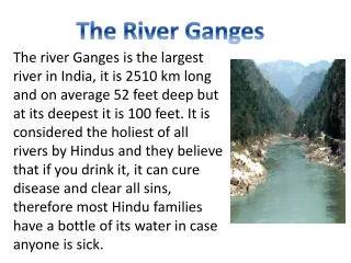
The Ganges Water Conflict. Prof. Hem Raj Subedee , Ph.D. Conflict, peace and department studies Tribhuvan , University Kathmandu, Nepa l. Ganga. Rises in the Gangotri Glacier in the Uttar Kashi District of UP at 3139 m. elevation.

E N D
The Ganges Water Conflict Prof. Hem Raj Subedee, Ph.D. Conflict, peace and department studies Tribhuvan, University Kathmandu, Nepal
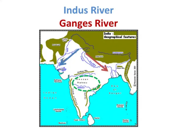
Ganga • Rises in the Gangotri Glacier in the Uttar Kashi District of UP at 3139 m. elevation. • Important Tributaries: Mahakali, Gandak, Kosi and Karnali from Nepal and china(Tibet). • Has total length of 2600 Km and total drainage area of about 1080000 sq. km(shared by India, china and Nepal). • Average Annual flow rate of 12105 m3/sec and a flow volume of 382 billion cubic metre.
The Crux of conflict • Water Management problem comes from the dramatic seasonal variations in rainfall. • Problem compounded with the creation of new national borders throughout the region. • Abundant water during Monsoon(June to October)- Average flow: 24526 m3/sec. • Water stressed during non-monsoon months(January-May)- Average flow: 2199 m3/sec (Rahaman, 2005a).
Conflict over the Ganges water between Bangladesh and India dates back to 1951 when India decided to Construct Farakka Barrage in order to divert water from Ganges to the Hooghly river through 42 km long feeder canal with a capacity of 1133 m3/sec. • Operation started in 1975 • Sharing and controlling of water became the key source of controversy. • Two nations Signed two treaties in 1977 and 1996. • Two Memorandums of Understanding in 1983 and 1985.
Farakka Barrage • 2246 metres long • 17 km upstream of Bangladesh near Monohorpur. • Close to the point where the main flow of the river enters Bangladesh and the river Hooghly continues in West Bengal past Kolkata. • Two Objectives: • To maintain navigability of this river and flush out the silt deposited in the Kolkata port • To ensure saline free water supply for Kolkata city. • The then Pakistan government opposed the construction of barrage because the reduction of dry season flow would have serious implications for Bangladesh.(Abbas, 1984; Crow et al., 1995). • Farakka barrage was built without the consultation with Bangladesh and began operation on 21st of April, 1975.
Consequences • Average flow of Ganges decreased substantially in Bangladesh. • Pre-Farakka flow: 2340 m3/sec • Post-Farakka flow: 1236 m3/sec
Issue’s nature • The problem typical of conflicting interests of up- and down-stream riparian. • India, as the upper riparian, - has rights for water diversions for its own irrigation, navigability, and water supply interests. • Initially Pakistan, and later Bangladesh, has interests and right for protecting the flow of the river for its own down-stream uses.
1977 Agreement and 1996 Treaty • Two countries signed treaties to solve long standing issues. • As of today, it is a major source of dispute between two countries. • Bangladesh submitted complain to the UN General Assebly in 1976 and expressed concerns to the Commonwealth summit held at Cyprus in October 1993. Again raised the issue to the 50th UN General Assembly. • First Agreement on direction of UN General Assembly,1976- on sharing of the Ganges waters at Farakka and on augmenting its flow was signed on 5th November 1977 at Dhaka for 5 years. • Water divided between Bangladesh and India in an overall ration of about 60% for Bangladesh and 40% for India.
80 percent guarantee clause: This clause guaranteed Bangladesh a minimum of 80 percent of its share during each period whatever low the flow of the Ganges may be during that period. • Article 4 established a Joint Committee to observe and record at Farakka the daily flows below Farakka Barrage and in the Feeder canal in India as well as Hardinge Bridge Point in Bangladesh. • Article 7 states that the Joint Committee is responsible for implementing the water sharing arrangements and examining any difficulties arising out of the implementation of the sharing arrangement and of the operation of the Farakka Barrage. This Article also provides mechanism for the settlement of disputes.
Agreement expired on November, 1982 but was not renewed. • On 7th October 1982, The Memorandum of Understanding was signed at New Delhi between India and Bangladesh. This agreement was valid for 2 years. • On 22 November 1985 another Indo-Bangladesh Memorandum of Understanding was signed at New Delhi and the agreement was valid for 3 years. • The water Sharing arrangements was almost the same as the 1977 agreement, however the 80 percent guarantee clause of 1977 was not included in either. • There was no water sharing agreements from 1989 to 1996.
1996 Treaty • On 12th Dec. 1996, the two governments signed the recent treaty on sharing Ganges water at Farakka during dry season( Jan- may). • Treaty valid for 30 years. • Bangladesh share decreased by 8 percent in comparison to 1977 agreement(Salman,1998). • Even during the three critical non-monsoon months(March-May), Bangladesh share decreased from 61% in 1977 to 50% under 1996 treaty. • Water allocated to Bangladesh in 1996 treaty was found to be approx. 50 percent less than the pre-Farakka average flow at HardingeBrige point of Bangladesh- This Treaty unlikely to make any difference for solving water crisis during dry season
Absence of minimum guarantee clause- does not indicate the entitlement in terms if absolute volume of water for each country on a day to day basis. • Does not provide clear dispute resolution mechanisms- If JC fails to resolve conflict, it be referred to Indo-Bangladesh JRC. If still remains unsolved,, it shall be referred to the two governments which shall meet urgently to resolve the discussion. • No arrangement for long-term solution of the dry season water scarcity. • For augmenting the Ganges flow the cooperation of other riparian countries including Nepal and China are vital.1996 treaty does not provide mechanism to approach other riparian countries of the Ganges basin to find the long term sustainable solution of the crisis. • Does not provide any authority or responsibility to Indo Bangladesh JRC for implementing the treaty. • This treaty approves the theory of equitable allocation and obligation not to cause significant harm of International law through inclusion of the principles of equity, fairness and no harm.
Conclusion • Concept of State Sovereignty from the National frontier point of view, as it is presently understood and applied, is no longer absolute. • The claim to absolute sovereignty over the Ganga has no past or present acceptance in international law. • Any basin state may exercise its right in the form and to the degree that it deems desirable but on the condition that it does not impair the same territorial sovereign right of its co-basin states. • The physical unity of the Ganga and the dependence of the basin states upon the basin and its resources create a regime of mutual interdependence and reciprocal obligation among the basin states with respect to the exploitation of the basin and the apportionment of the benefits.