Download
1 / 14

E N D
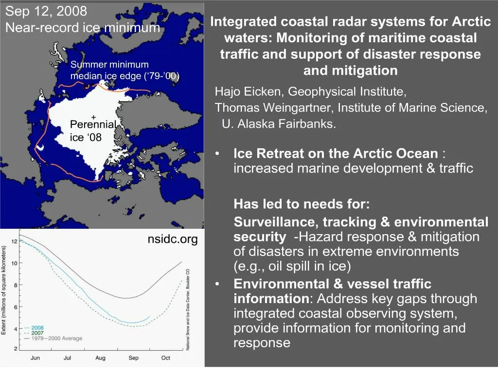
1. Integrated coastal radar systems for Arctic waters: Monitoring of maritime coastal traffic and support of disaster response and mitigation Hajo Eicken, Geophysical Institute,
Thomas Weingartner, Institute of Marine Science,
U. Alaska Fairbanks.
Ice Retreat on the Arctic Ocean : increased marine development & traffic
Has led to needs for:
Surveillance, tracking & environmental security -Hazard response & mitigation of disasters in extreme environments (e.g., oil spill in ice)
Environmental & vessel traffic information: Address key gaps through integrated coastal observing system, provide information for monitoring and response
3. Increase in breadth and intensity of uses of ice environment requires coordination and management New, potentially overlapping or conflicting uses of sea ice
Management & enforcement challenged to adapt to rapid environm�l change & variability
Information needed at local scale relevant to a variety of stakeholders Multiple Users and multiple scales of use � use varies seasonally:
Many disparate uses are �crowded� in time and space.
Coastal zone � subsistence, biological habitata, engineering issues
Regional � transport, marine industrial development, migratory routes and species protection
Pan-Arctic: transport, development, national security, climate concerns
Multiple Users and multiple scales of use � use varies seasonally:
Many disparate uses are �crowded� in time and space.
Coastal zone � subsistence, biological habitata, engineering issues
Regional � transport, marine industrial development, migratory routes and species protection
Pan-Arctic: transport, development, national security, climate concerns
4. Note landfast ice extent in May with rapid changes by JulyNote landfast ice extent in May with rapid changes by July
5. Improving cold-regions maritime domain awareness through an integrated coastal observing system Remote sensing* (km-scale and < daily; passive systems cloud sensitive)
Coastal radar (sub-km scale and continuous)
Aerial surveys, ice & sub-ice sensor systems* (wx dependent or point measures)
Local knowledge*: Potentially important role for disaster respons
Integrate data streams, GIS-based decision support systems through existing ocean observing system resources (AOOS.org) and partnering with Arctic Observing Network Why need an ice radar at Barrow when satellites can �Do it�? Passive- lots of clouds; temporal coverage (3 � 4 days at best) � inadequate for feature tracking or hazard response. Ice radar bridges time and space scales.Why need an ice radar at Barrow when satellites can �Do it�? Passive- lots of clouds; temporal coverage (3 � 4 days at best) � inadequate for feature tracking or hazard response. Ice radar bridges time and space scales.
6. Coastal radar: Surveillance & disaster response Preliminary work indicates great promise of marine radar (S/X-band) for analysis of ice & vessel movement
Development of automated tracking algorithms, integration with other data streams into decision support system
Design & field test integrated system at Barrow: Broad, representative range of ice conditions, hazards & activities Rings are 1 nm, continuous in time, max range 10 km. Goal: Develop an S or X band system w a range of 50 km and ready for operational use by the USCG: �Technical Readiness Level 5.�Rings are 1 nm, continuous in time, max range 10 km. Goal: Develop an S or X band system w a range of 50 km and ready for operational use by the USCG: �Technical Readiness Level 5.�
14. Next steps Coordination with other CIMES PIs
Identification of information needs (industry, local communities, enforcement & response) to develop information integration approaches
Experts Workshop on Assessing & Reducing Environmental Risks in Offshore Oil & Gas Development (November 2008 - Barrow, Alaska (www.alaska.edu/ipy/north2020/oil.xml), engaging industry, local organizations & gov�t regulators & enforcement
Development systems & target identification & tracking algorithms w/ synthetic and preliminary data