Download

1 / 21
210 likes | 333 Views
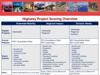
Dollarton Highway Realignment Project. District of North Vancouver. May 12, 2006. Project Area. Maplewood Mudflats. Maplewood Mud Flats Conservation Area. New Dollarton ROW. Environmentally Sensitive Area. Maplewood Mudflats Conservation Area.

E N D
Dollarton Highway Realignment Project District of North Vancouver May 12, 2006
Maplewood Mudflats Maplewood Mud Flats Conservation Area New Dollarton ROW
Environmentally Sensitive Area • Maplewood Mudflats Conservation Area. • Protect a rare & vital Burrard Inlet ecosystem • Groundwater dependencies. • Water Quality. • Wildlife habitat & migration corridors.
Scope of the Project • New Roads Constructed. • Dollarton Highway Realignment – 1.1 km major arterial, 4 lane divided • Riverside Drive East – 0.3 km major collector, 4 lane undivided. • Other roads – 0.9 km local commercial/industrial, 2 lane undivided. • Carried out in 5 phases starting in 1999 and completed in 2003 • Total cost of project approx $8 Million
Technical Requirements • Drainage Design • Must service the entire drainage area. • Safe disposal of storm water. • Groundwater recharge • Minimize post-development flow impacts. • Provide overflows to storm sewer for large storms
Existing Site Conditions • Native soils - well graded sandy gravel / gravelly sand • High water table (anywhere from 1.0m to 5m below surface • Measured hydraulic conductivity 1x10⁻³ to 4x10⁻³ m/s (medium permeability) • Flat terrain – road grades from 0.5% to 3.7%
Design Considerations • Incorporate groundwater recharge into the design . • Used dispersal drains for 49 of the 69 catch basins installed. • Use gasketed joints for storm sewers to avoid groundwater table draw down. • Include trench dams to prevent groundwater from following trench lines to the outfall.
Typical Road Cross Section Infiltrating CB system
Catch Basin Dispersal Drains Infiltrating CB system
Dispersal Drain Plan View Dispersal Drain Detail
Dispersal Drain Section Dispersal Drain Detail
Marine Outfall Adapted O&G Chamber design based on previous research & experience. Design low flow bypass in sewer main to divert water into chamber when most needed. Better treatment (TSS removal) and less frequent maintenance, virtually no re-suspension of entrained sediment.
Marine Outfall Oil & Grit Interceptor
Marine Outfall • Riparian planting plan for rip rap slope between elevations 2.5 and the top of the slope • Ecopockets planted @ 1 plant per 1.5 m2 or as directed by the environmental monitor • Riparian planting stock • Red osier dogwood • Black Hawthorn • Pacific WIllow
Low flow diversion weir Treated water outfall Oil & Grit Interceptor