Download
1 / 17
170 likes | 305 Views
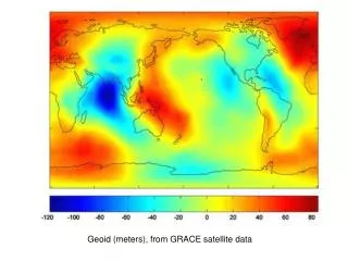
Progress in Geoid Modeling from Satellite Missions. John Ries Center for Space Research The University of Texas at Austin. 2009 Workshop on Monitoring North American Geoid Change Boulder, Colorado 21-23 October 2009. GRACE Mission Status. Mission Highlights Geoid models

E N D
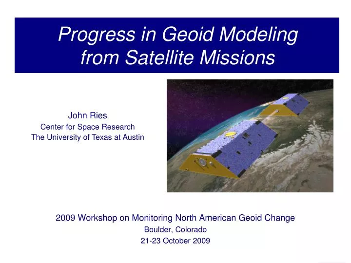
Progress in Geoid Modelingfrom Satellite Missions John Ries Center for Space Research The University of Texas at Austin 2009 Workshop on Monitoring North American Geoid Change Boulder, Colorado 21-23 October 2009
GRACE Mission Status • Mission Highlights • Geoid models • Mean fields: GGM03C, EIGEN-GL05C, ITG-GRACE03SEGM2008 • Time variable fields (86 monthly solutions through August 2009) • Nearly 100 % of scientific measurements for over seven years have been collected and analyzed • NASA 2009 Senior Review successful • Extension to 2011 approved by NASA • DLR approved mission funding through 2009 • Last steps being taken to assure funding past 2009 • Flight Segment Generally Robust • All systems in nominal operation • Certain sub-systems are single-string on both s/c • New thermal regimes to conserve battery life • Instrument performance continues to meet mission requirements Orbit Launched: March 17, 2002 Over 7 years in orbit Initial Altitude: 500 km Current Altitude: ~460 km (-10 m/day) Inclination: 89º Eccentricity: ~0.001 Separation Distance: ~220 km Non-Repeat Ground Track, Earth Pointed, 3-Axis Stable Predicted Lifetime: 2013+
more power improvement Progress from EGM96 GFZ05C=EIGEN-GL05C
Improvement in GRACE-only Models GGM01S-EGM96 (deg/order 120) GGM02S-EGM96 (deg/order 120) GGM03S-EGM96 (deg/order 120) mgal Scale is +/- 10 mgal
Progress in Gravity Determination from Space GGM01S (111 days of GRACE data) GGM03S (4 years of GRACE data)
Estimated Total Geoid Error GFZ05C=EIGEN-GL05C
Degree-banded GPS Leveling Test Limiting the test to a selected degree range using a degree-banded approach (Huang et al., 2002), 1149 GPS/leveling points over Canada were compared to the GGM02C, EIGEN-GL04C, and EGM2008 geoids With EGM08, test now appears to be limited by GPS/leveling data errors, not geoid
Short Wavelength Marine Geoid ResidualsEIGEN-GL04C The residuals are the difference between a ‘high-frequency DOT’ defined as (GSFCMSS00 – geoid) and the same DOT smoothed to ~900 km (to degree/order 360) Scale is +/- 25 cm ‘Blending’ space-based and terrestrial gravity information smoothly and without ‘artifacts’ has been one of the most significant challenges
Short Wavelength Marine Geoid ResidualsEIGEN-GL05C The residuals are the difference between a ‘high-frequency DOT’ defined as (GSFCMSS00 – geoid) and the same DOT smoothed to ~900 km (to degree/order 360) Scale is +/- 25 cm. As GRACE component becomes more accurate and skill in blending the two pieces of information improves, ‘artifacts’ are greatly reduced
Short Wavelength Marine Geoid ResidualsEGM2008 The residuals are the difference between a ‘high-frequency DOT’ defined as (GSFCMSS00 – geoid) and the same DOT smoothed to ~900 km (to degree/order 360) Scale is +/- 25 cm. EGM2008 is relatively free of ‘artifacts’ while also providing the most accurate and highest resolution marine geoid model (degree/order 2159+)
microgal Secular Gravity Changes (1) Difference between two 2-year means (2003-2004 and 2005-2006) Arctic and North America Antarctic
microgal Secular Gravity Changes (2) Difference between two 2-year means (2003-2004 and 2005-2006) Europe Asia
Secular Gravity Changes (3) Long-term geoid change due to ∆J2 ~ 0.2 mm/yr
Seasonal Geoid Variations 1 mm geoid ≈ 2 cm water Mass variations are observed in Amazon basin with ~400 km resolution A clear separation can be observed between the large Amazon watershed and the smaller watersheds to the north (e.g., the Orinoco watershed), indicating that basin-scale variability is resolved.
Gravity field and steady-state OceanCirculation Explorer (GOCE) • Launched March 2009 • Drag-free mode May 2009 • Allows operation at ~270 km • Measurement mode September 2009 • Mission lifetime ~18 months
Impact of GOCE on Geoid Accuracy Combining GOCE with GRACE is expected to extend geoid resolution from space by a factor of 2 or more Note that the long wavelength geoid information (including temporal variability) must be provided by GRACE-type missions
In The Near Future Continue routine operations and delivery of good quality data and products RL05, Quick-Look fields, and other exciting developments… Extension of Memorandum of Understanding between NASA and DLR on extended GRACE mission operations Closely monitor data and products for any signs of aging or environmentally related degradation in quality GRACE Science Team Meeting: Nov 5-6, in Austin, TX (USA) http://www.csr.utexas.edu/grace/GSTM Registration is now open Looking forward to the contribution of GOCE to geoid accuracy