Download
1 / 18
180 likes | 370 Views
Virginia’s Statewide Aquatic Gap Analysis Project. A Species-Habitat Affinity Database. Shelly Miller Kevin Gooss Virginia Dept. of Game and Inland Fisheries Wildlife Diversity Division. Some background on our efforts…. Established team of regional experts representing

E N D
Virginia’s Statewide Aquatic Gap Analysis Project A Species-Habitat Affinity Database Shelly Miller Kevin Gooss Virginia Dept. of Game and Inland Fisheries Wildlife Diversity Division
Some background on our efforts… Established team of regional experts representing Virginia Tech (Fish and Wildlife and Biology dept.) Virginia Commonwealth University VDGIF VA Dept. of Conservation and Recreation (DNH) Conservation Management Institute (VA Tech) Developed preliminary work plan • Began analysis with development of Ecological Drainage Units • Represent one level of the hierarchical classification scheme • Basically is a combination of physiography and drainage • 31 identified in Virginia
Gathered comments from team on EDU delineation and posed the following question: What are the primary landscape-scale variables influencing the distribution of species in stream habitats? Stream size Connectivity Gradient Hydrology/permanence of flow Geology/soils Temperature (Tidal)
Data gathering for reach classification National Hydrography Dataset (NHD): USGS, flow validated (1:100,000) National Elevation Dataset (NED): USGS (30 m raster) Geology and generalized lithology: USGS (1:500,000) Smaller hydrologic units: VA Dept. of Conservation and Recreation 500 for the state Biological data: VDGIF Collections database (point locations) DRGs of USGS 7.5’ topographic maps
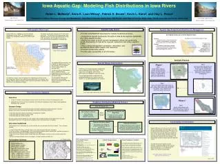
Upper Tennessee River watershed and beyond Concurrent multi-state project just underway at CMI/VA Tech Progress NHD processing Holston, Clinch/Powell, Rappahannock, James Habitat attribution of Holston Unique identifier** Size Connectivity Geology/lithology Gradient Mean elevation Cool/Coldwater designation Waterbody identification**
NHD processing and attribution Software: ArcInfo and ArcMap (ArcGIS 8.0) using tools developed by MoRAP, USFS and TNC staff Time: 2-3 days per watershed Result: Arc Coverage of stream segments with many attributes Next steps: Categorization and typing of reaches Addition of species information
Species-Habitat Affinity Database ArcGIS- and MSAccess-based process and products Timely application VDGIF Online database re-engineering Migrating data from AREV to MS Access platform Products of aquatic GAP efforts will inform re-engineering How? Habitat preference and location data currently housed in AREV database have been imported into Access Identified challenges, table relationships, etc.
Structure of Species-Habitat Affinity database 1) Stream reaches Linked by segment id number 2) Species collections Linked by species id number 3) Species-habitat data from literature
Holston data summary (VA only) ~1300 collection records with over 14,000 individual species records Representing: 108 fish species 37 aquatic mollusk species 19 are federal and/or state listed
Need to attribute species collections data with unique segment id Spatial join of point data to reaches Resulting file contains attributes of both datasets and a distance measurement Data were reviewed using information in original records and DRG topos. Point greater than 10 m from stream reach Points near confluences
To the Access database Import species collections data with segment id and species id Import stream reach data with segment id Import environmental and taxonomic data from existing database with species id Create joins and relationships between these tables. Begin to examine patterns, identify outliers, etc.
Aaahhh, what a tangled web we weave… Species collection data Stream reach data Literature data
Results from query for reaches with Tennessee dace (Phoxinus tennesseensis)
Results from query for reaches with slabside pearly mussel (Lexingtonia dolabelloides)
Identify and fill in gaps in habitat data from the literature ~100 species have no environmental association data in existing database Now what…short range next steps Continue NHD processing and attribution for entire state Coordinate with neighboring states to share data and create more biologically meaningful products Create simple data entry forms Create watershed-scale species distribution maps and gather expert review Determine and apply categories of continuous variables Size, connectivity, gradient Gather input from team (how many categories, regionalization, etc.) Examine patterns using database and GIS Determine “types”, concatenation of existing variables e.g., small, high gradient, coldwater stream connected to medium-sized stream
Time frame for completion of statewide project- 2005 State Wildlife Grants Program (i.e., CARA-lite) Requires completion of a Comprehensive Wildlife Conservation Plan by Fall 2005 Products of gap analysis projects fit well as a part of these comprehensive plans These grants can be used to fund the on-the-ground projects suggested by gap analysis.
Thanks to: Virginia Aquatic Gap Team in particular, Paul Angermeier, Dick Neves, and Greg Garman Scott Sowa, Gust Annis, and Michael Morey, MoRAP Bruce Johnson, USGS Dave Hatfield, USFS Tom Fitzhugh, TNC Blair Jones, CMI Kevin Gooss, VDGIF, co-author