Download
1 / 25
260 likes | 776 Views
Section 1: Landforms and Resources. Landscape Influenced Development: The United States

E N D
1. Physical Geography of the United States and Canada Chapter 5
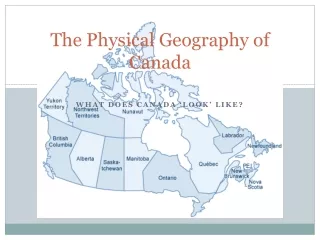
2. Section 1: Landforms and Resources Landscape Influenced Development: The United States & Canada is known as Anglo America because both countries were colonies of Great Britain & most people speak English. The two countries are bound together by physical geography & cultural heritage, but also strong economic & political ties.
4. Vast lands: Canada is second in size & the U.S. is third. Russia is rank as the largest.
Abundant Resources: both have natural resources, fertile soils, water, vast forests, and large deposits of different minerals.
Resources attracted immigrants & it has enabled them to become economic powers.
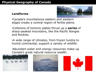
7. Many and Varied Landforms The Eastern Lowlands: flat coastal plain.
One section is called the Atlantic Coastal Plain & runs to the Gulf Coastal.
The Appalachian Highlands: its extend 1,600 miles from Newfoundland in Canada to Alabama. 400 million years old.
Interior Lowlands: this area was flattened by huge glaciers thousands of years ago. It includes rolling hills, lakes, rivers, & most fertile soil.
Divided into 3 subregion: interior plains, Great Plains, & Canadian Shield.
8. Western Mountains: massive rugged Rocky Mountains. It extend 3,000 miles, from Alaska to New Mexico. 80 millions years old.
Continental Divide is the line of highest points in the Rockies that marks the separation between rivers flowing eastward & westward. The Islands:
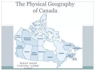
Canada�s are Ellesmere, Victoria, & Baffin.
United States: Hawaiian islands.
9. Resources Shape Ways of Life: Oceans & Waterways: Canada & the U.S. have ample of water resources. Three oceans: Atlantic, Pacific, & Arctic.
Great lakes: Huron, Ontario, Michigan, Erie, & Superior.
Rivers: Mississippi-Missouri-Ohio & the Rio Grande. Canada�s is the Mackenzie River.
Land & Forests: both countries are large & contain some of the most fertile soils in the world. North America is the world�s leading food exporter. They also have huge forest, � of Canada is covered by woodland, the U.S. is 1/3. Both countries are major producers of lumber & forest products.
11. Minerals and Fossil Fuels The U.S. & Canada have large quantities & different kinds of minerals & fossils fuels.
This resources gave them the means to industrialize rapidly.
In the Canadian Shield: iron ore, nickel, copper, gold, & uranium.
Western Mts: gold, silver, copper, & uranium.
Both have substantial deposits of coal, natural gas, and oil, & well developed network to move this fossil fuels.
The U.S. is the world�s biggest consumer of energy resources. It is a major importer of this fuels. Most of Canada�s energy exports go to the U.S.
13. Climate and Vegetation Section 2
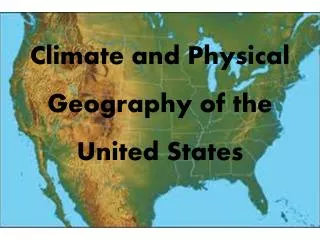
14. Climate & vegetation: Part A Colder Climates:
1. Arctic coastlines of Alaska and Canada; huge, treeless plain; also the Rocky Mts. & Pacific ranges.
2. Tundra/long, bitter cold winters, brief summers in Arctic areas; varying temperatures in mts.
3. Permafrost, permanently frozen ground along Arctic coastlines. Moderate Climates:
4. North Central & Northeastern U.S. & much of southern Canada; also Pacific Coast.
5. Humid continental climate with short summers in the upper part of the north central zone; marine west coast in the Pacific coast.
6. Prevailing westerlies affect the Pacific coast climate.
15. Part B: U.S. Climate Zones Milder Climates: Southern states�humid subtropical climate with hot summers & mild, cool winters: central & southern coast of California�Mediterranean climate with dry, sunny, warm summers & mild winters
Dry Climates: Great Plains and dry northern parts of the Great Basin�Semiarid climate with dry weather; southwestern states�desert climate.
Tropical Climates: Hawaii�wet climates that support rain forests; Florida�wet & dry seasons
16. Human-Environment Interaction in Canada & The U.S. Chapter 5 Section 3
17. A Human Perspective The sun-baked American Southwest was a harsh environment for its early inhabitants, the ancestors of today�s Pueblo peoples. But these early settlers, made good use of available resources. From the land, they took clay and stone building materials. They built multi-room, apartment-like dwellings in cliffs. This gave protection against daytime heat, nighttime cold, and human and animal enemies. From plants and animals, the early settlers got food and clothing. They survived because they adapted to their environment.
18. Settlement & Agriculture Alter the Land Settlement: First inhabitants nomads, probably migrated from Asia over Beringia
Agriculture: Made settlements permanent; remains an important activity in both the United States and Canada.
19. Building Cities Montreal: is Canada�s 2nd largest city & a major port. It has adapted to the cold by building underground areas.
Los Angeles: mild climate drew thousands and urban sprawl began, as well as problems like air pollution, inadequate water, and construction on land where earthquakes are likely to occur.
23. Overcoming Distances Trails & waterways: Trials for transportation/movement included the early National & Wilderness roads, & Oregon & Santa Fe trails. Canals included the Erie, as well as the U.S. and Canada�s most important deepwater ship route, the St. Lawrence Seaway.
Transcontinental railroads: In both the U.S. & Canada, rail lines across the country permanently changed the landscape, promoted economic development, & helped create national unity.
National highway systems: Extensive highway systems in both the U.S. & Canada accommodate & promote heavy reliance on the automobile.
25. Questions: 1. Which mountain Range is oldest?
Appalachian Mts.
2. How do Canada and the United States rank in size compared with other countries?
Second & third
3. What large bodies of water surround the United states and Canada?
Atlantic & Pacific oceans, Gulf of Mexico, Arctic Ocean
4. What are three common resources in the United States?
Petroleum, natural gas, coal
5. What are three common resources in Canada?
Hydroelectric power, copper, timber
26. 6. Which country produces more minerals?
Neither; they are about equal
7. Why doesn�t the United States export as many minerals as Canada?
It uses up too many to export
8. Why is Canada colder than the United States?
Because it lies farther north
9. What kinds of climates do not exist in Canada?
Desert or tropical
10. Where which climate would you most likely find a rain forest?
tropical